NOAA collects shoreline data for nautical charts using remote sensing
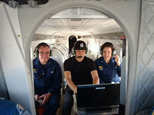
Left to right: Rear Adm. Shep Smith, Jamie Kum, and Capt.
Liz Kretovic acquire shoreline imagery in a NOAA Twin Otter.
On Wednesday May 2,
Rear Adm. Shep Smith and
Capt. Liz Kretovic joined NOAA pilots
Lt. JC Clark and
Lt. Adam Ruckman, and
Jamie Kum as they took to the air in NOAA Twin Otter N57RF to acquire shoreline imagery for application into NOAA nautical charts on the bay side of the eastern shore of Maryland. The NOAA National Geodetic Survey’s (NGS)
Remote Sensing Division plans and acquires aerial photography and compiles shoreline data using Light Detection and Ranging (lidar) technology. Lidar is an active remote sensing system that uses the round trip travel time of a laser pulse from the aircraft to the ground to calculate highly accurate spot elevation. During the course of the two and a half hour flight, the crew flew along several overlapping transect lines parallel to the coast. The water quality was excellent and allowed for the lidar to penetrate 5-10 meters of water, which increases the accuracy of coastal bathymetry and data applied to NOAA nautical charts. For more information contact
Elizabeth.Kretovic@noaa.gov@noaa.gov.
NOAA makes forecast data easier to display in marine navigation systems
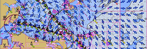
Rose Point’s Coastal Explorer, one example of many
navigation software packages available, displays NOAA
surface current data.
Coast Survey recently started producing
NOAA operational forecast system (OFS) data in formats that are easily ingested by marine navigation systems, making data access more convenient for those needing to make critical decisions on the water. OFS are national networks of operational nowcast and forecast models that can be used for activities such as search and rescue, recreation boating, fishing, and storm effect tracking. In addition to displaying nowcasts and forecasts in real-time navigation system displays, these data can also optimize route planning for commercial ships. Ultimately, these model forecast data will be available for machine-to-machine exchange, with data file sizes small enough to enable delivery from shore to vessel over existing communication and data networks. Read more on our
blog. For more information contact
Neil.D.Weston@noaa.gov.@noaa.gov.
Children at the 2018 NOAA Kids Day enjoy activities with NOAA Coast Survey
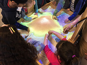
Kids move sand to form topographic features in the interactive
sandbox.
Volunteers from Coast Survey interacted with more than 140 six- and seven-year-olds for the 2018 NOAA Kids Day. Coast Survey brought an interactive sandbox that displayed a 3-D dynamic topographic map. By moving the sand around to make mountains and valleys, kids learned how underwater topography can change over time and also about the importance of NOAA nautical charts in helping mariners navigate artifacts on the seafloor. Coast Survey's exhibit included a model NOAA ship and the children asked questions to NOAA Corps officers
Lt. Cmdr. Matthew Forney and
Lt. Matthew Forrest about life at sea.
Lorraine Robidoux coordinated the Coast Survey volunteers, which included
Paul Turner,
Melanie Feliciano,
Kristen Crossett,
Gina Digiantonio,
Corey Allen,
Patrick Keown, and
Doug Wood. For more information contact
Lorraine.Robidoux@noaa.gov.
NOAA Coast Survey participates in a hurricane table top exercise
Every two years the Federal Emergency Management Agency conducts a national level exercise, that is a two-week event to test and evaluate the readiness of federal, state, local, and tribal governments to protect against, respond to, and recover from a catastrophic incident in a coordinated and unified manner. This year's exercise was based on a major hurricane impact to the mid-Atlantic and national capital region. Working with NOAA's Homeland Security Program Office, Coast Survey’s Navigation Services Division used simulated daily hurricane forecasts to run a table top exercise and plan navigation response team (NRT) efforts for hurricane "Cora." For a week, navigation managers and a team from headquarters planned where to stage personnel and NRT assets to support response efforts. This culminated in the preposition of all NRTs to support the hurricane's final landfall on Hampton Road and subsequent track though Washington, DC. The exercise was one of many preparations Coast Survey is making in advance of the 2018 hurricane season. For more information contact
James.M.Crocker@noaa.gov.
NOAA Ships
NOAA Ship Ferdinand R. Hassler - Alongside Curtis Bay Coast Guard Base south of Baltimore for dockside repair period.
NOAA Ship Thomas Jefferson - Conducted a search for cargo containers that fell off a ship outside Approaches to Chesapeake Bay. Thomas Jefferson arrived at the Approaches to Houston survey area this week.
NOAA Ship Fairweather - Completed survey work in southeast Alaska for the IOCM-USGS Queen Charlotte Fault project and then transited to Tracy Arm to conduct additional surveys.
NOAA Ship Rainier - In Lake Washington, Seattle, pending repairs. Rainier's launches are preparing to survey areas of Puget Sound while the ship is in dry dock.
Navigation Response Teams
NRT 1 - Team is in Stennis Space Center, Mississippi, and will be fully staffed once hiring and officer rotation is complete. Boat is survey and response ready.
NRT 2 - Team is in Fernandina Beach, Florida. Boat is survey and response ready.
NRT 3 - Team will be fully staffed once hiring and officer rotation is complete. Boat was cross decked and is now survey and response ready.
NRT 4 - Team is in Galveston, Texas. Boat is undergoing repairs to inertial measurement unit and will be response ready when completed.
NRT 5 - Team is assisting NRT 1 with HSRR and training. Boat is survey and response ready.
Bay Hydro II - Bay Hydro II is survey and response ready.

Staff Updates
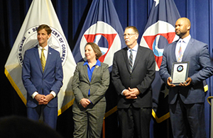
Left to right: Rear Adm. Gallaudet, Nicole LeBoeuf, and
Russell Callender, present Terence Lynch with LCDP
graduation plaque.
Coast Survey’s
Terence Lynch was among the graduating class, Class 10, of the NOAA Leadership Competencies Development Program (LCDP). Lynch, a lead management and program analyst, completed four developmental assignments in the Integrated Ocean and Observing Systems (IOOS) Program Office, NESDIS Chief Financial Officer/Chief Administrative Officer Division, the National Ocean Service, and the Department of Commerce’s Enterprise Services Office during his time in the program. The NOAA LCDP is a competitive 18-month program that provides a series of training and learning experiences for NOAA employees who have a high potential for assuming greater leadership responsibilities in the agency.
Office Reconfiguration
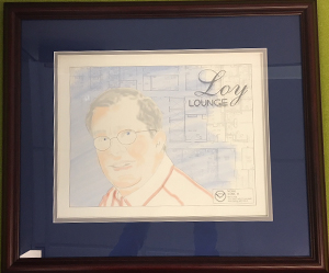
A dedication to Curt Loy located in Loy Lounge, the Coast
Survey staff hang-out area on the 6th floor. Image drawn by
Coast Survey’s very own Rick Powell.
Last week, Coast Survey completed its eighth and final phase of the Silver Spring reconfiguration with the Marine Chart Division’s move into their new location. The reconfiguration was a 16-month phased project that was planned nearly four years ago by now-retired, former Resource Management Staff Chief Curt Loy. While the physical moves of employees are complete, there are remaining items that will cap off the reconfiguration later this year, including rebuilt large and medium conference rooms (with better A/V for teleconferencing), repaired chairs, and an office-wide wireless network on the 6th and 7th floors. We thank you for your patience throughout the move.