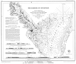
Online "NOAA Custom Chart" lets boaters create their own charts
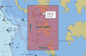
NOAA Custom Chart makes it easy for users to create a
personalized chart.
A prototype version of a powerful new online tool, NOAA Custom Chart, is now available for boaters and other nautical chart users. The application enables users to define the scale and paper size of custom-made nautical charts centered on a position of their choosing. NOAA Custom Chart is an easy way for boaters to create a paper or digital "back-up" for the electronic chart system or other GPS-enabled chart display that they are using onboard. Read more about this new capability on our
blog. For more information contact
Colby.Harmon@noaa.gov.
Hydrographic Services Review Panel holds public meeting in Miami
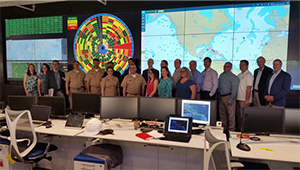
HSRP panel members visited Carnival Cruise Line’s fleet
operation center in Doral, Florida.
Last week, the Hydrographic Services Review Panel (HSRP) met in Miami, Florida, for their biannual meeting. The panel, which advises the NOAA administrator on products and services related to navigation services, water levels and currents, and positioning, received updates on impacts from the 2017 hurricanes Irma and Maria, coastal and maritime community risk reduction, and regional Florida and Caribbean priorities. The two-day public meeting followed the dedication of a new Physical Oceanographic Real-Time System (PORTS®) in PortMiami as well as a tour of Carnival Cruise Line’s fleet operation center, both setting the stage for discussions on the importance of foundational data for port planning and operations. Coast Survey navigation response teams and regional navigation managers were also recognzied for their contributions to reopening ports following last year's hurricanes. For information on this panel, recent agenda, and presentations please visit the
HSRP website. For more information contact
Lynne.Mersfelder@noaa.gov.
U.S. and Canada sign memorandum of agreement at the U.S.-Canada Hydrographic Commission meeting
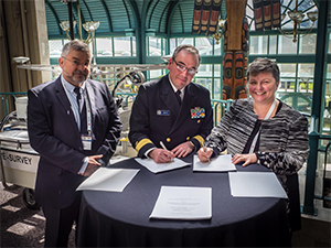
Captain Abraham Kampfer, IHO director, Rear Adm. Shep
Smith, and Dr. Geneviève Béchard.
Rear Adm. Shep Smith and the Hydrographer General of Canada, Dr. Geneviève Béchard, signed a memorandum of agreement (MOA) between the Office of Coast Survey and the Canadian Hydrographic Service for cooperation in hydrography. The MOA was signed in the context of the one day
U.S.-Canada Hydrographic Commission which meets in the spirit of the International Hydrographic Organization's (IHO) aim to map the worlds ocean and ensure that all the world's seas, ocean, and navigable waters are surveyed and charted. Canada and the U.S. are two of 88 member states of the IHO. The MOA provides the framework by which the neighboring nations may collaborate to achieve greater efficiencies in hydrographic operations, such as the collection and exchange of survey data, increased compatibility and uniformity of charts and related navigational publications, and others. The two nations are now pursuing the establishment of a new hydrographic geospatial products and services committee, integrating respective navigational chart rescheming plans, and preparing a technical conference in September on remote sensing applications in charting, among other activities during the upcoming year. The next meeting will be on March 21, 2019, just preceding the U.S. Hydro Conference in Biloxi, Mississippi. For more information contact
Jonathan.Justi@noaa.gov.
U.S. Committee on the Marine Transportation System highlights electronic navigation charts
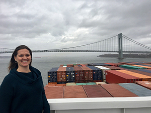
Allison Wittrock on board a container ship entering the Port of
New York/New Jersey.
U.S. Committee on the Marine Transportation System (CMTS)
social media shared an interview with
Allison Wittrock, branch chief of the Northeast, Lake Ontario, and Lake Erie in the Marine Chart Division, where she explained how Coast Survey is working to give nautical charts a 21st century makeover with ENCs. ENCs enable more information to be included on nautical charts and allow Coast Survey to update the charts on a weekly basis, keeping users informed about the 20,000 updates made to nautical charts around the U.S. annually. The advent of ENCs is expected to make navigation of U.S. waters safer, more precise, and more efficient, and is a critical component of our maritime infrastructure and the marine transportation system. For more information contact
Allison.Wittrock@noaa.gov.
NOAA releases documentary on women’s service in the NOAA Corps
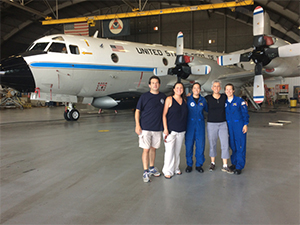
The production team interviewed two film subjects on location
at the Aviation Operation Center in Tampa, Florida. (Left to
right) Bob Schwartz, Crescent Moegling,, Lt. j.g. Shanae
Coker, Timi Vann, and Cmdr. Cathy Martin.
NOAA recently released “Women of NOAA Corps: Reflections of Sea and Sky,” a 31-minute historical documentary on the lives and stories of ten women in the NOAA Corps service. Coast Survey’s
Crescent Moegling, northeast regional navigation manager, co-produced the video and
Capt. Liz Kretovic, Coast Survey's deputy hydrographer, is one of the film subjects. The film elevates public understanding and appreciation of the NOAA Corps, particularly women’s service in the Corps, and to inspire the next generation of women in scientific service to country. You can view Women of NOAA Corps on our
blog. For more information contact
Crescent.Moegling@noaa.gov.
NOAA navigation manager gives hydrographic and coastal mapping seminar to graduate students
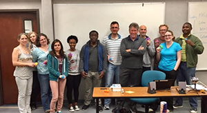
Tim Osborn with graduate students from the University of
Southern Mississippi.
Tim Osborn, regional navigational manager for the central Gulf coast, participated in the yearly collaboration with the University of Southern Mississippi (USM) in the education and planning of field projects for their expanding hydrographic surveying program. Starting as a master's program, USM is moving into hydrographic surveying curriculum at the undergraduate level as well. Each year, Coast Survey meets and gives seminars to the class and assists in planning spring and summer survey projects, as part of their education program. This year, the USM program comprises members of the U.S. Navy and representatives from international hydrography and charting programs. USM is an important partner with NOAA and many state and federal efforts along the Gulf. For more information contact
Tim.Osborn@noaa.gov.
NOAA Ships
NOAA Ship Ferdinand R. Hassler - Returned to the Approaches to Chesapeake survey grounds last week after repairs.
NOAA Ship Thomas Jefferson - Alongside in Norfolk, Virginia, for repairs.
NOAA Ship Fairweather - Alongside in Newport, Oregon and is scheduled to sail towards Seattle on 4/16, where she will complete hydrographic systems readiness review (HSRR) activities.
NOAA Ship Rainier - In Lake Washington, Seattle, for HSRR activities.
Navigation Response Teams
NRT 1 - Team is in Stennis Space Center, Mississippi. Boat is survey and response ready.
NRT 2 - Team is in Fernandina Beach, Florida. Boat is survey and response ready.
NRT 3 - Operations will resume when hiring and initial crew training is complete. Crossdeck to new boat planned for 2018.
NRT 4 - Team is in Galveston, Texas. Boat is survey and response ready.
NRT 5 - Team is assisting NRT 3 with crossdecking and training.
Bay Hydro II - Bay Hydro II is survey and response ready.
Contractor Operations
Leidos - Demobbed, acquisition complete.
Oceaneering - Demobbed, acquisition complete.
David Evans and Associates - Demobbed, acquisition complete.