NOAA Coast Survey offers new certification program in nautical cartography
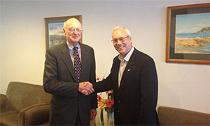
CAPT Andy Armstrong (left) with IBSC Chair Adam Greenland
at the 40th meeting of the IBSC in Willington, New Zealand.
The International Board on Standards and Competence for Hydrographic Surveyors and Nautical Cartographers (IBSC) recognized and approved Coast Survey’s new certification program in cartography (CAT-B) at their 40th meeting in Willington, New Zealand.
CAPT Andy Armstrong (NOAA, ret.), co-director of the
Center for Coastal & Ocean Mapping/Joint Hydrographic Center at the University of New Hampshire, presented the program at the meeting. The new program will grant certificates to up to 13 cartographers per year, through a combination of lectures, hands-on chart production experience, work details to various branches within the Coast Survey, and field trips to working hydrographic survey vessels. The first class (which is already full), will begin in fall 2017 at Coast Survey headquarters in Silver Spring, Maryland. The duration of the program is 51 weeks and comprises six courses. Read more on our
blog.
Mississippi River Commission holds its annual spring high-water inspection
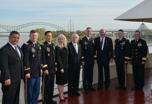
Members of the MRC: Mr. Charles Camillo, Executive Director;
Col. Richard Pannell, Secretary; Brigadier General Mark Toy,
Commissioner; Honorable Norma Jean Mattei, Ph.D.,
Commissioner; Honorable Sam Angel, Commissioner; Major
General Michael Wehr, President; Honorable R.D. James,
Commissioner; Brigadier General David Hill, Commissioner;
and Rear Admiral Shepard Smith, Commissioner. (Photo
courtesy: MRC)
Last week
Rear Admiral Shepard Smith participated in the
Mississippi River Commission (MRC)
high-water inspection trip aboard the M/V
Mississippi as a commissioner. RDML Smith was appointed to the MRC by President Obama in December 2016. The MRC holds a high-water inspection every spring and a low-water inspection every fall. The purpose of these trips and public meetings is to hear testimony about issues that affect the Mississippi River basin including environmental, flood control, navigation, water security, engineering, and the promotion of commerce. During this particular trip, four meetings were scheduled aboard the
Mississippi in Hickman, Kentucky; Memphis, Tennessee; Greenville, Mississippi; and Baton Rouge, Louisiana. Since 1879, this seven-member presidentially appointed commission has led the sustainable management and development of water-related resources of the Mississippi River basin for the nation’s benefit and the people’s well-being.
Coast Survey attends the American Association of Geographers conference
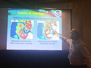
Shachak Pe'eri presenting at the AAG conference.
Kathleen Jamison, Coast Survey's resource manager,
Shachak Pe'eri, chief of Marine Chart Division's Chart Standards Group, and
John Nyberg, chief of the Marine Chart Division, attended the
American Association of Geographers (AAG) conference last week in Boston, Massachussets. Jamison attended several diversity and inclusion sessions and served on a AAG panel regarding the progress and issues of diversity and inclusion in geography fields within academia and federal agencies. During the conference, she worked to promote and recruit cartographers and physical scientists for OCS programs. Dr. Pe'eri gave a presentation on large scale nautical chart updates using data collected during Super Storm Sandy relief. Nyberg presented on cruise ship traffic in the Caribbean with an emphasis on the future of U.S.-Cuba cruise infrastructure. He also attended an
International Cartographic Association meeting to prepare for the
International Cartographic Conference in July.
Another great showing of the Coast Survey sandbox
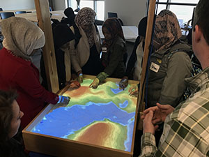
Students explore the 3D sandbox at the Maritime and Marine
Science Experiential Day at the Seattle Maritime Academy.
Crescent Moegling, Northwest and Pacific Islands navigation manager, and
Peter Holmberg, Pacific Hydrographic Branch, participated in the Maritime and Marine Science Experiential Day at the Seattle Maritime Academy. It was another great showing of the 3D sandbox as many groups of students stopped to learn more about hydrography and how the sandbox worked in general. The team also highlighted Coast Survey’s charting mission to several local high school students. To read or hear more about this event, visit
KNKX's story.

NOAA Ships, NRTs, and Contractors:
NOAA SHIP
THOMAS JEFFERSON
Thomas Jefferson has been busy conducting hydrographic survey readiness review (HSRR) activities in preparation for the field season. It is anticipated they will be departing Norfolk, Virginia, for their project near Savannah, Georgia, on May 15, 2017.
NOAA SHIP
FERDINAND R. HASSLER
Bravo zulu to the
Hassler and her crew for the great work they performed all winter long while the newsletter's operations section was on hiatus. During that time,
Hassler conducted surveys on the approaches to Jacksonville, Florida. On April 3, the vessel got underway from her homeport and transited to Baltimore, Maryland, to begin her shipyard period.
NOAA SHIP
RAINIER
Rainier has been wrapping up the winter repair activities and left port on April 11 bound for Olympic Coast National Marine Sanctuary.
NOAA SHIP
FAIRWEATHER
Fairweather has been busy preparing for the field season with HSRR activities. The ship is scheduled to leave for the beginning of the field season on April 25, bound for the West Prince of Wales project. The Simrad/Kongsberg 2040s multibeam echo sounders have been installed and once underway, full acceptance testing will begin. A big thank you to
LCDR Sam Greenaway for being instrumental in the acquisition of these new systems for the ship.
BAY HYDRO II
Bay Hydro II is currently conducting HSRR activities with the assistance of
Mike Annis, Navigation Services Division.
LTJG Sarah Chappel recently presented and participated in the
The Hydrographic Society of America (Student Outreach Program) at the
U.S. Hydro Conference in Galveston, Texas.

Staff Updates
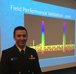
LT John Kidd successfully defended his thesis on April 6, 2017.
Congratulations to
LT John Kidd for successfully defending his thesis on the evaluation and calibration of the Velodyne industrial laser scanner. For the safety of navigation, it is important to identify and map the horizontal location and vertical elevation of exposed marine surface features such as piers, piles, and exposed rocks. The use of survey-grade laser scanners to improve upon traditional shoreline survey methods has historically been considered to be cost-prohibitive. An in-depth performance evaluation was conducted at the University of New Hampshire using the Velodyne VLP-16 system, a low-cost industrial-grade mobile laser scanner to investigate the laser scanner’s accuracy of range estimates as a function of distance and angle of incidence, angular separation between individual beams, and data density as a function of mounting orientation and scanner settings. The uncertainty of these key parameters was derived from multiple experiments conducted under both well-controlled laboratory and realistic field conditions. The results of the study demonstrate that the use of a low-cost industrial-grade mobile laser scanner can be used for completing shoreline surveys with the performance that can meet survey requirements for charting purposes. Additionally, this study demonstrates that the Velodyne VLP-16 can also be used as a validation tool for measuring air gaps of bridges and overhead power cables crossing the channel. Questions? Contact
LT John Kidd.
Awards
The Bronze and Distinguished Career Award ceremony will be held at the NOAA Auditorium in Silver Spring, Maryland, on Tuesday, May 23, 2017. The Bronze Medal Award is the highest honor award granted by the Under Secretary of Commerce for Oceans and Atmosphere. The bronze medal recognizes superior performance by federal employees. The following officers and Coast Survey staff will be honored:
The Office of Oceanic and Atmospheric Research recognized John Kelley for contributing to the successful development and transition of the next-generation Lake Erie Operational Forecasting System into NOAA operations.
ENS Max Andersen, ENS Marybeth Head, Alex Ligon, LT Joseph Carrier, LT Matthew Forrest, RDML Shepard Smith, Kirk Andreopoulos, Michael Peperato, LT Damian Manda, and LT Eric Younkin are recognized for rapid integration and deployment of Autonomous Surface Vessels for hydrographic use aboard the NOAA Ship Thomas Jefferson.