Innovative DriX ASV begins sea trials at NOAA/UNH Joint Hydrographic Center
Video: DriX returns to the launch/recovery vessel. In shipboard operation, the launch/recovery vessel will be deployed by davits.
A DriX autonomous surface vessel (ASV) developed by University of New Hampshire industrial partner iXBlue has been delivered to the Center for Coastal and Ocean Mapping/Joint Hydrographic Center (CCOM/JHC) for testing and development as a hydrographic survey force multiplier. The innovative vessel design allows for higher speeds, longer endurance, and improved sea-keeping for coastal and offshore multibeam mapping. The DriX is being provided to CCOM by iXBlue as part of the center’s industrial partnership program in which companies provide products of value to CCOM in return for collaborative research and development opportunities and access to CCOM-developed technology.
With grant funding from the NOAA Office of Marine and Aviation Operations (OMAO), CCOM/JHC will work with iXBlue to design, build, and refine a system for launch and recovery of the DriX from the survey launch davits on NOAA’s hydrographic survey ships. Throughout the winter and spring, the CCOM/JHC ASV research team will be testing the DriX launch and recovery systems in New Hampshire, enhancing the survey autonomy systems, and developing survey protocols for operational use. In the summer, the CCOM/JHC team and iXBlue engineers will take the Drix aboard NOAA Ship Thomas Jefferson for an operational survey project.
For more information contact Andy.Armstrong@noaa.gov.
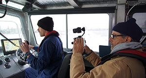
NOAA Ship Thomas Jefferson tests drone use for shoreline mapping
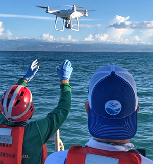
Lt. j.g. Matt Sharr (left) and Capt. Brian Taggart (NOAA, ret.)
(right) deploy the DJI Phantom 4 drone from one of NOAA Ship
Thomas Jefferson’s survey launches.
Coast Survey and the National Geodetic Survey (NGS) recently conducted operational tests of small unmanned aerial systems — or drones — on board
NOAA Ship Thomas Jefferson in support of survey operations conducted along the south coast of Puerto Rico. The tests show the potential of imagery from low-cost off-the-shelf drones to meet NOAA survey specifications for near-shore and shoreline feature mapping. This could replace traditional shoreline verification and mapping techniques used by NOAA hydrographic survey field units. Potential benefits of using drones for shoreline mapping include: improved data collection efficiency compared to data collection from small skiffs; more accurate feature investigation than traditional techniques; and, most importantly, removal of personnel from potentially dangerous situations (i.e. survey in close proximity to features being mapped). For more information read our
blog story or contact
Matthew.Sharr@noaa.gov or
Charles.J.Wisotzkey@noaa.gov.
Coast Survey meets with marine industry stakeholders in the Gulf
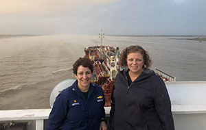
Capt. Liz Kretovic and Lucy Hick joined Capt. Peterson from
the Associated Branch Pilots on the 147-meter tanker,
Barbouni, as it traveled along the Mississippi River.
Recently,
Tim Osborn, western Gulf coast navigation manager;
Louis Licate, South Florida, Puerto Rico, and U.S. Virgin Islands navigation manager;
Lucy Hick, acting chief of the Customer Affairs Branch;
Rear Adm. Sam DeBow (NOAA, ret.), contractor with Lynker Technologies; and
Capt. Liz Kretovic, deputy hydrographer, staffed a booth at the
International WorkBoat Show alongside colleagues from OMAO. Held every year in New Orleans, the show attracts 15,000 members of the commercial marine industry, who come together from around the world to network, learn, spot new industry trends, and uncover innovative products and solutions. Being in New Orleans provided an opportunity to interact with partners and stakeholders in the area. On November 29, the Louisiana Maritime Association held its annual meeting, where U.S. Coast Guard, U.S. Army Corps of Engineers, and the local river pilots provided updates. Capt. Kretovic presented on NOAA's Precision Navigation program. Additionally, the Coast Survey team had the opportunity to travel with the pilots along the Mississippi River to see first-hand how they use NOAA products to make crucial split-second navigation decisions, as well as learn about their requirements for services such as additional current meters and air gap sensors. For more information contact
Lucy.Hick@noaa.gov.
NOAA's nowCOAST® provides access to Gulf of Maine operational forecasts and Chesapeake Bay marine pathogen forecasts
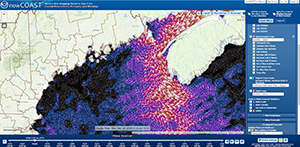
Depiction of surface water currents from the Gulf of Maine
Operational Forecast System.
nowCOAST® now provides access to two new map services including oceanographic forecast guidance from the National Ocean Service (NOS) 3-D operational forecast system for the Gulf of Maine (GoMOFS) and NOS forecast guidance of the marine pathogen, Vibrio Vulnificus (Vv), for the Chesapeake Bay.
GoMOFS provides high resolution nowcasts and forecast guidance of circulation in the coastal ocean, specifically coastal water levels and 3-D currents, temperatures, and salinity at 3-hourly increments out to 48 hours. NOS’
latest forecast guidance on the probability of occurrence of Vv, a marine pathogen which can cause illness and hospitalization, is issued once per day for Chesapeake Bay and includes predictions for the present day (Day 1) and the next day (Day 2). The National Weather Service website provides
additional information on these and other updates provided in this latest version of nowCOAST. For more information contact
John.Kelley@noaa.gov.
Coast Survey Leads U.S. Delegation to Meso American - Caribbean Sea Hydrographic Commission
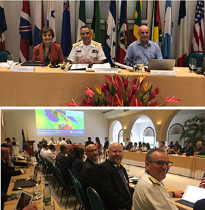
Top image: Kathryn Ries, Rear Adm. Enrique Flores Morado,
chair of the MACHC (at the time of this photo), and Alberto
Costa Neves, IHO assistant director. Bottom image: Eric
Villalobos (Navy), John Lowell (NGA), and Rear Adm. Shep
Smith.
Office of Coast Survey leadership attended the
Meso American - Caribbean Sea Hydrographic Commission (MACHC) in Cartagena de Indias, Colombia, during the last week of November. Agenda highlights included regional capacity building, Seabed 2030, disaster response, and marine spatial data infrastructure.
John Nyberg, chief of the Marine Chart Division, led the U.S. delegation at the meeting. Other members of the U.S. delegation included representatives of the National Geospatial-Intelligence Agency and the U.S. Navy.
Rear Adm. Smith attended in his capacity as chair of the International Hydrographic Organization Council.
Katie Ries, deputy director of Coast Survey, was elected chair of the MACHC at the conclusion of the meeting. For more information contact
Kathryn.Ries@noaa.gov.
Navigation response team demonstrates survey operations to National Geographic
Lt. j.g. Dylan Kosten demonstrates survey operations while
National Geographic camera operator looks on.
Coast Survey’s navigation response team from New London with team lead
Lt. j.g. Dylan Kosten, and team members
Eli Smith and
Michael Bloom, met up with a National Geographic production crew while in the New York City area to demonstrate the survey capabilities of our response teams. The demonstration brought them through the Hell Gate area, a historically notorious channel known for its wrecks, where the team took CTD casts and provided an educational demonstration of a survey. Their efforts will be featured in an upcoming National Geographic television series. For more information contact
Dylan.Kosten@noaa.gov.


Staff Updates
Jay Nunencamp, Coast Survey’s environmental compliance coordinator (ECC), is on detail as the acting chief of the Policy and Planning Division within the Office of National Marine Sanctuaries for the next few months. During this time, Giannina DiMaio, NOS ECC, and Rachel Krasna, Center for Operational Oceanographic Products and Services ECC, will be backfilling for him.

Alexanderia Allison.
Coast Survey front office staff welcomes
Alexanderia Allison to the federal workforce. Alexanderia is a graduate of Howard University School of Communications with a bachelors degree in legal communication. Alexanderia is a seasoned administrative professional who provides executive level support to leadership in the front office.
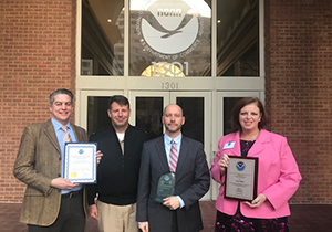
Andre Van der Westhuysen, Capt. Rick Brennan, Jay
Nunencamp, and Lucy Hick following the NOS annual
employee recognition and awards ceremony.
Congratulations to our Coast Survey colleagues who were honored at the NOS annual employee recognition and awards ceremony on December 3.
Lucy Hick (acting chief, Customer Affairs Branch) received the 2018 NOS Equal Employment Opportunity and Diversity Award.
Jay Nunenkamp received the 2018 Employee of the Year Award.
Andre Van der Westhuysen (National Weather Service) was nominated by Coast Survey and received the NOS Peer Recognition Rafting Award.