NOAA Ship Rainier surveys Channel Islands to support safe navigation and habitat mapping
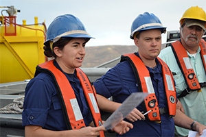
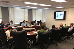
Ensign Levano, Lt. Clos (acting XO), and Kirk Perry (lead
fisherman) at morning safety meeting before deploying
survey launches near San Miguel Island.
NOAA Ship
Rainier recently arrived off the Santa Barbara coast to complete hydrographic surveys at NOAA’s
Channel Islands National Marine Sanctuary (CINMS) as part of the
Southern California Seafloor Mapping Initiative. Over the next month, the ship will use their new multibeam echo sounders to support safe navigation and update nautical charts for the sanctuary. In addition to providing data for crucial nautical chart updates, the surveys will also generate backscatter imagery, which the sanctuary uses for habitat mapping. Read more on the
Coast Survey blog. For further information, contact
Michelle.Levano@noaa.gov.
Congressional visit in Charleston Harbor
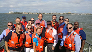
Southeast navigation manager, Kyle Ward, meets with
congressional representatives in Charleston Harbor.
Kyle Ward, southeast navigation manager, met with Representatives Sanford (R-SC), Shuster (R-PA), Denham (R-CA), and Joyce (R-OH) aboard a U.S. Coast Guard response boat in Charleston Harbor, South Carolina. Kyle highlighted Coast Survey's recent hydrographic work in Charleston harbor as well as the Physical Oceanographic Real-Time System's (PORTS®) two air gap sensors. For further information, contact
Kyle.Ward@noaa.gov.
Coast Survey hosts annual ocean modeling workshop
FVCOM workshop in Silver Spring, MD.
Coast Survey Development Lab (CSDL) and NOAA's Center for Operational Oceanographic Products and Services (CO-OPS) hosted a Finite Volume Community Ocean Model (FVCOM) workshop on September 28-29. FVCOM is one of the hydrodynamic models used by NOAA for operational coastal ocean modeling.
Changsheng Chen and
Bob Beardsley, of the University of Massachusetts in Dartmouth, visit NOAA annually for this workshop to coordinate closely with NOAA modelers on FVCOM model applications that are being developed, tested, and transitioned to operations at NOAA. Workshop participants included CSDL’s Coastal Marine Modeling Branch, CO-OPS’ Oceanographic Division, the Great Lakes Environmental Research Laboratory, NWS’ Office of Water Prediction, and Remote Sensing Solutions. For more information, contact
Edward.Myers@noaa.gov.
Redesigned Coast Survey website coming in early November
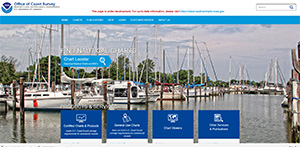
Redesigned nauticalcharts.noaa.gov homepage.
The Coast Survey web rebuild team is on its way to deploying a new
nauticalcharts.noaa.gov website by early November 2017. This upgrade will feature a completely new look and feel, as well as organize information, products, and services in a way that make it easier for the public and other partners to use. In addition to improved look and feel, the new website will address several NOAA and NOS requirements for websites, such as Section 508 compliance and compatibility for the visually impaired. The new site is also fully compatible with mobile devices, with its new, responsive design. Many folks are involved in this effort across Coast Survey, including
David Barglow,
Saron Desta, and
Thanh Pham (CSDL/ITSB),
Kristen Crossett (Communications),
Scott Sherman and
Lucy Hick (NSD),
Colby Harmon (MCD),
Tyanne Faulkes (HSD), and
Georgios Britzolakis (CSDL). For more information, contact
Neeraj.Saraf@noaa.gov.
Project highlight: Gulf of Maine Operational Forecast System
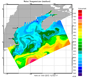
Sea-surface temperature field produced by a Gulf of
Maine Operational Forecast System test run.
CSDL and CO-OPS have recently completed development and transition of a new operational hydrodynamic model, the
Gulf of Maine Operational Forecast System (GoMOFS). GoMOFS will produce real-time nowcast and short-range forecast guidance for water levels, 3-dimensional currents, water temperature, and salinity over the broad Gulf of Maine region. It is designed to support marine navigation, harmful algal bloom forecasting, emergency response, and coastal zone management. The system domain covers the Gulf region, including eastern Long Island Sound, the Gulf of Maine/Georges Bank, and the coast of Nova Scotia. GoMOFS uses the Regional Ocean Modeling System as its core hydrodynamic model and is able to resolve coastal ocean hydrodynamic features as fine as 700 m. Results from both the research mode hindcast and the nowcast/forecast test runs have demonstrated that the system performance fully satisfies the design requirements. GoMOFS has been approved for operational implementation by the National Centers for Enviornmental Prediction (NCEP) and is undergoing pre-operational tests on the NCEP high-performance computing system. It will begin operational production in early FY18. For further information, contact
Zizang.Yang@noaa.gov.

Coast Survey concludes Hurricane Maria response in Puerto Rico
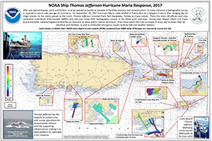
Poster of NOAA Ship Thomas Jefferson's response efforts
following Hurricane Maria.
NOAA Ship Thomas Jefferson spent the last three weeks in Puerto Rico and the U.S. Virgin Islands surveying ports and bays in response to Hurricane Maria. Over the three week period, the crew surveyed 13 areas and no fewer than 18 individual port facilities, as well as conducted emergency repairs to three tide and weather stations. PS
Doug Wood from Coast Survey's Hydrographic Surveys Division and
Cmdr. Chris van Westendorp, commanding officer of NOAA Ship
Thomas Jefferson, compiled a
poster highlighting all of the areas they surveyed. For more information, contact
Douglas.Wood@noaa.gov.
Coast Survey responds to Hurricane Nate
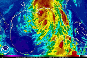
Hurricane Nate GOES Satellite image on October 7, 2017.
Hurricane Nate made its second landfall as a Category 1 hurricane near Biloxi, Mississippi in the early hours of October 8, 2017. In response, NOAA Office of Coast Survey deployed two navigation response teams (NRT) to assist with port restoration efforts in Gulfport, Mississippi and Pensacola, Florida. In addition, survey coordination with USCG and USACE was facilitated through
Tim Osborn, Central Gulf Coast Navigation Manager, who was stationed in Mobile, AL. NOAA NRT 4 (
Dan Jacobs, Erin Diurba, Charles "Wess" Rowland) traveled from Galveston, Texas to complete hydrographic survey work in the port of Gulfport, a container and bulk seaport. Concurrently, NRT 2 (
James Kirkpatrick, Lucas Blass, Howard "Howie" Meyers), travelled from Fernandina Beach, Florida to survey the bulk and freight port of Pensacola. For more information, contact
James.Crocker@noaa.gov.
NOAA ship, NRT, and contractor operations
Weekly Hydro Ship Activity Report: Week of October 1
NRT 1 - Team is in Mobile, AL. Operations are suspended until the team's training is complete.
NRT 2 - Team is back in Fernandina Beach, FL, after surveying the Pensacola, FL, area following Hurricane Nate. Vessel crossdeck is complete, boat is survey and response ready.
NRT 4 - Team is back in Galveston, TX, after surveying the Gulfport, MS, area following Hurricane Nate. Vessel crossdeck is complete, boat is survey and response ready.
NRT 5 - Team is in New London, CT. Vessel crossdeck is complete, boat is survey and response ready.

Staff Updates
Kenia Allen, ERT, has joined the Formatting and Distribution System (FADS) branch to assist with weekly data processing, data collection, and other tasks. She may be familiar to some, as she worked here previously as a contractor in the Marine Chart Division (MCD) with Enterprise Information Solutions (EIS).
MCD welcomes Mei-Ling Freeman who is moving from CSDL to serve as the NCSII System Manager.
Awards
Lt. Cmdr. Meghan McGovern received the NOAA Corps Outstanding Volunteer Service Medal for her dedicated volunteer service supporting the South County Habitat for Humanity in Rhode Island. Over a three-year period, Meghan completed over 100 hours of volunteer work, which included constructing four homes and assisting with the rehabilitation of two additional homes—providing safe and affordable housing for multiple families.
Diversity and Inclusion
On Thursday, October 5, the Coast Survey Diversity and Inclusion Committee hosted a lunchtime tabletop game event. We had a great turnout (including visitors from NGS's Remote Sensing Division) and lots of fun. Even the most novice of players were able to jump right in and play several rounds of
Fluxx,
Tsuro, and
Exploding Kittens. Special thanks to
John Macek for spearheading this event and to
Mike Brown and
Joe Courange for sharing their games and expertise. Look out for another tabletop game event in November!
This is the latest in a series of fun, social, and inclusive activities that the D&I Committee hope to host in order to bring Coast Survey folks together and allow us to share our diverse interests with colleagues. If you have any ideas of events that you would like to host, please contact
lucy.hick@noaa.gov or a member of the
Diversity and Inclusion Committee.