NOAA RNC Tile Service displays first ENC-only product
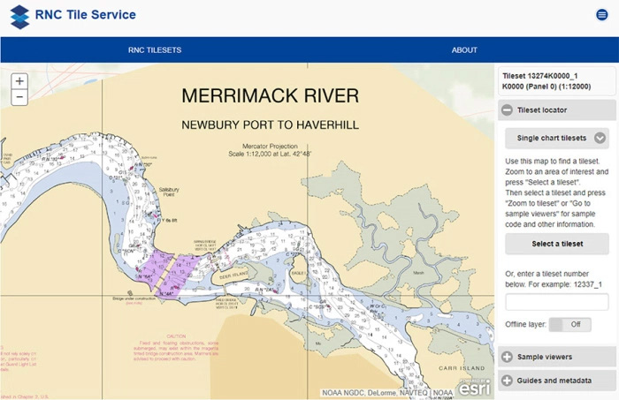
The Merrimack River, located in Massachusetts, is just south
of the New Hampshire border. The single chart tile set for this
area is named 13274K0000_1.
Coast Survey released its 1:12,000 electronic navigational chart (
NOAA ENC®) of the Merrimack River, Massachusetts, in the
RNC Tile Service. This is the first time a navigational chart—created solely as ENC product—is included in the tile service. The tile service renders a traditional depiction of the nautical chart for use with GPS-enabled electronic chart systems or other “chart plotter” display systems to provide real-time vessel positioning for recreational mariners. This chart is included in the single chart tile sets and the quilted tile sets both in the online and offline versions. The tile service version of the
Merrimack chart retains the look of a NOAA paper chart but is derived from the ENC charting database. This gives users the opportunity to use ENC-only data with a traditional NOAA chart feel. NOAA intends to incorporate all future charts that are produced only as ENCs into the tile service (ENC-only charts are outlined in the
National Charting Plan, page 25). This update to the RNC tile service also includes the ArcGIS
Tile Metadata Service, adding support for source chart metadata from within ArcMap and other GIS applications. Read more on our
blog.
For more information, contact
Mark.Griffin@noaa.gov.
MIST survey of Columbia River provides training opportunity for navigation response teams
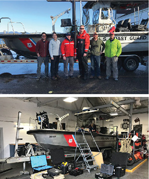
The MIST and USCG survey crew: Tim Wilkinson (NRT3),
Erin Diurba (NRT4), BMC Chris Sheppard, BM1 Kyle Abel,
Alex Ligon (NRT1), and Michael Annis (HQ)
(top image). Setting up the MIST kit (bottom image).
Last week, the Navigation Response Branch’s mobile integrated survey team (MIST) traveled to Astoria, Oregon, to conduct a side scan and single beam sonar survey. The U.S. Coast Guard (USCG) requested a survey of the Mott Basin area to confirm charted depth and obstruction data. The MIST group used this as an opportunity to give navigation response team experience with setup, usage and tear down of MIST equipment, as well as to perform a system "shakedown" prior to the upcoming hurricane season. The MIST equipment was installed and integrated on a USCG Trailerable Aids to Navigation Boat (TANB) vessel. TANB vessels are normally used for navigation aid maintenance, but can serve as a vessel of opportunity for MIST equipment to be installed for hydrographic surveys. For more information, contact
Michael.Annis@noaa.gov.
Navigation response team surveys for recreational boat traffic safety in Tampa Bay
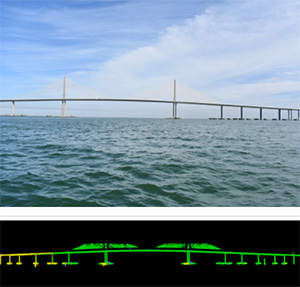
The center spans of the Sunshine Skyway Bridge (above)
were successfully captured from lidar data (below).
NRT2, homeported in Fernandina Beach, Florida, with
James Kirkpatrick (team lead),
Lucas Blass, and
Howie Meyers, conducted a survey around the Sunshine Skyway Bridge, which spans Tampa Bay. The U.S. Coast Guard (USCG) and additional members of the Tampa Bay Harbor Safety Committee requested the work and expressed interest in establishing alternate routes for recreational boating traffic. Lt. j.g. Patrick Debroisse from NOAA Research Vessel Bay Hydro II installed a topographic lidar system on NRT2, which marked the first time a lidar system was employed from an NRT boat. The lidar system enabled 3D data to be collected for those portions of the bridge that are above water line. The accurate positional and dimensional information gleaned from this data will be used to compliment extensive hydrographic sonar data collected beneath the surface. Together, the complete data set will enable full consideration of area features, both above and below the water line, in determining the placement of alternative routes. Read more on our blog. For more information, contact
James.Kirkpatrick@noaa.gov.
Basic hydrographic training course held in Newport, Oregon
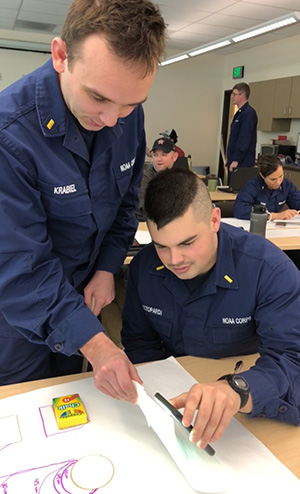
ENS Krabiel and ENS Azzopardi practice desktop side scan
measurements. Credit: ENS Pickett
Hydrographic Systems and Technology Branch concluded its annual Basic Hydrographic Training Course (BHTC) in Newport, Oregon, this February. Training kicked off with an address from
Rear Adm. Shepard Smith, who gave encouraging words on the importance of this training, and the opportunities for innovation within the hydrographic community. A total of 23 students attended, with participation from
Fairweather,
Thomas Jefferson,
Rainier, and 3 NRT units. BHTC provides new hires both theoretical and practical instruction in hydrographic topics, covering topics ranging from acoustic theory to field practices, to immersive hydrographic processing software. We would like to thank the instructional support received from
Tyanne Faulkes and
Pete Holmberg of the Pacific Hydrographic Branch,
Jack Riley,
Eric Younkin, and
Lt. Cmdr. Sam Greenaway of HSTB, and
Cmdr. Mark Van Waes,
Lt. Cmdr. Michael Gonsalves,
Lt. Damian Manda of
Fairweather. Moving forward, hydrographic training will transition to the supervision of
Lt. Matthew Forrest, Operations Branch. For more information, contact Lt. j.g.
Shelley.Devereaux@noaa.gov.
Workshops provide collaboration opportunities for Navy, NOAA
Last week, the Navy held their annual Fleet Oceanographic Support Workshop at Stennis Space Center, Mississippi. The intent of the workshop was to prioritize the oceanographic, hydrographic, and bathymetric data requirements from each region covered by the Navy around the globe.
Capt. Crocker,
Capt. Brennan, and
Cmdr. Lomnicky attended the workshop looking for better ways to collaborate with the Navy on hydrographic data collection requirements. As a result, discussions are underway to support the Navy in conducting Maritime Homeland Defense surveys in a number of economically significant ports, validating bathymetric anomalies detected from satellite altimetry, and supporting the deployment of oceanographic gliders. Following the workshop, the NOAA representatives attended the NOAA-Navy Hydrographic Surveying Working Group meeting and laid out several opportunities for collaboration, including personnel exchanges and joint training. A recent success of this collaboration was the attendance of several members from the Navy's Fleet Survey Team at this year's Field Procedures Workshop. In the future, we are looking forward to a tight integration between the Navy's Fleet Survey Team and NOAA's own NRT stationed at Stennis Space Center.
For more information, contact Capt.
Richard.T.Brennan@noaa.gov.
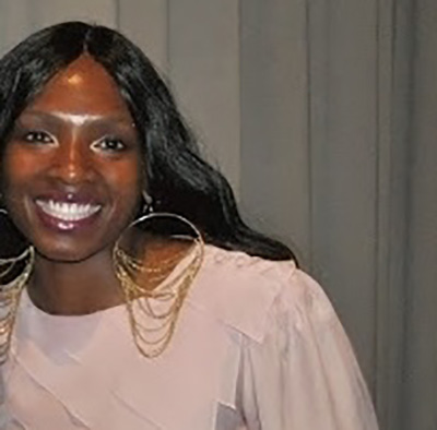
Geneviève Béchard appointed as director general, Canadian Hydrographic Services

Geneviève Béchard, director
general, Canadian Hydrographic
Services.
The Canadian Hydrographic Service has announced that effective February 21, 2018, Dr. Geneviève Béchard will be joining the Department of Fisheries and Oceans Canada (DFO) as Director General, Canadian Hydrographic Service (CHS). With close to 30 years of experience in the federal public service, Geneviève is coming to the Department with extensive experience in leading national program development and implementation in science & technology organizations. Dr. Geneviève Béchard succeeds Mr. Denis Hains who retired from CHS in January.
For more information, contact
Jonathan.Justi@noaa.gov.

NOAA Ships
NOAA Ship Ferdinand R. Hassler - Underway and surveying the Approaches to Chesapeake Bay.
NOAA Ship Thomas Jefferson - Alongside in Norfolk, Virginia.
NOAA Ship Fairweather - Alongside in Newport, Oregon.
NOAA Ship Rainier - Alongside in Newport, Oregon.
Navigation Response Teams
NRT 1 - Team is in Stennis Space Center, Mississippi. Boat is survey and response ready.
NRT 2 - Team is in Fernandina Beach, Florida. Boat is survey and response ready.
NRT 3 - Operations will resume when hiring and initial crew training completed. Crossdeck to new boat planned for 2018.
NRT 4 - Team is in Galveston, Texas. Boat is survey and response ready.
NRT 5 - Team is returning to New London, Connecticut, from response operations in Maine. Boat is survey and response ready.
Bay Hydro II - Bay Hydro II is survey and response ready.
Contractor Operations
Leidos - Demobbed, acquisition complete.
Oceaneering - Demobbed, acquisition complete.
David Evans and Associates - Demobbed, acquisition complete.

Staff Updates
Capt. EJ Van den Ameele, chief of the Coast Survey Development Lab (CSDL), was selected to be the executive director to the deputy undersecretary for operations. This is a critical role for the operations of NOAA. EJ has had a powerful impact on the direction of the lab, setting the modeling program on a strong trajectory, and initiating an ambitious unmanned systems program, including a written and externally reviewed roadmap. Best of luck in your new position, EJ! In the meantime,
Neeraj Saraf, chief of Information Technology Services Branch (ITSB), will assume the duties of CSDL chief until a permanent chief is on board. Thank you to
Thanh Pham for stepping in as acting ITSB chief.
Nkolika (Nikki) Ndubisi.
Nkolika Ndubisi, who goes by
Nikki, joined the Coast Survey, Resource Management Staff on March 12 as a program analyst for a six month detail. Nikki is working alongside Amanda Phelps and Terence Lynch on all items related to budget formulation, planning, taskers, and other assorted duties, including the Coast Survey diversity internships program, the unmanned services grant program at the University of Southern Mississippi, and Government Accountability Office follow-up actions. Nikki will also be assisting Capt. Liz Kretovic as the program analyst assigned work on legislative and policy engagement. Nikki began her government career in the National Ocean Service (NOS) Management and Budget Office in July of 2002. During her 15 plus years of government service, she maintained a diverse workload. Among other duties, she serves as the NOS Freedom of Information Act officer, Federal Register liaison, a contracting officer representative, a property custodian, and a purchase card holder. In addition to the growing in her government career, Nikki was also committed to her educational pursuits. While working in NOS headquarters, she obtained her bachelor’s degree in social science with a minor in psychology. Nikki also recently completed a master’s degree in business administration and another master’s degree in project management.
The CSDL welcomes
Dr. Alex Kurapov. Dr. Kurapov has been working with NOS and the National Environmental Satellite, Data, and Information Service over the previous 3.5 years as part of an Intergovernmental Personnel Act (IPA) agreement with Oregon State University, where he served as an associate professor. He works on the development of the West Coast Operational Forecast System (WCOFS), a ROMS (Regional Ocean Modeling System)-based modeling system covering the west coast of the U.S. As part of this work, he evaluates ow data assimilation can be used in WCOFS, as this is the first NOS OFS system to be tested for data assimilation capabilities. Dr. Kurapov earned his Ph.D. from St. Petersburg Marine Technical University in Russia and has excellent expertise in oceanic data assimilation, coastal ocean modeling, and physical oceanography.
Deana Mastin has officially transferred from the Integrated Ocean and Coast Mapping (IOCM) Program to CSDL’s ITSB as a program specialist. Deana will be responsible for IT-related procurements and managing IT property as one of our custodians. She brings a wealth of knowledge from IOCM and OCS Front Office, as she previously served as a property custodian, handled Freedom of Information Act requests, and assisted with management of the IOCM website.