Gulf of Maine Operational Forecast System is operational
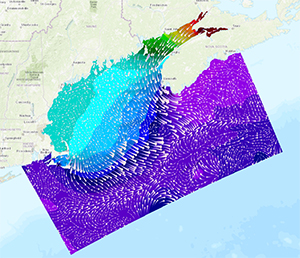
Sample display of the GoMOFS's nowcast output of the
surface current field (white arrows) and water levels
(background color) on 12:00 UTC, January 10, 2018.
The
Gulf of Maine Operational Forecast System (GoMOFS) became operational last week. GoMOFS predictions are now available to support safe and efficient marine navigation, emergency response, marine geospatial, and ecological applications. GoMOFS provides users with real-time nowcast and forecast guidance of surface water levels and 3-D fields of water currents, water temperature, and salinity out to 72 hours. The system's 3-D forecast fields will also be used in the future to drive NOAA's operational harmful algal bloom forecast system in the region. The Coast Survey Development Laboratory took the lead in the model development, while the Center for Operational Oceanographic Products and Services (CO-OPS) tested and transitioned the model to operations. The system now runs on NOAA’s Weather Climate Operational Supercomputing System (WCOSS) operated by National Centers for Environmental Prediction Central Operations. GoMOFS outputs will also be available on the
nowCOAST web mapping portal.
For more information, contact
Edward.J.VanDenAmeele@noaa.gov.
NOAA navigation services highlighted at Port of Houston tour
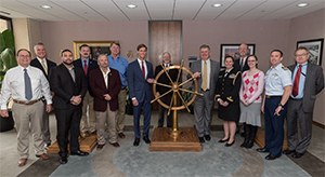
Alan Bunn (fifth from left) and Rear Adm. Gallaudet (seventh
from left) with Port of Houston VIP tour participants.
Last week
Alan Bunn, western Gulf coast navigation manager, attended the Port of Houston VIP tour and briefing with
Rear Adm. Gallaudet, assistant secretary of commerce for oceans and atmosphere. Other participants on the tour included U.S. Coast Guard (USCG) Captain of the Port of Houston/Galveston, USCG Director Vessel Traffic Center, U.S. Army Corps of Engineers Operations, Houston Pilots, and Houston Port Authority representatives. Several NOAA products were discussed as the port relies on the Physical Oceanographic Real-Time System (PORTS®), NOAA navigation response teams, National Water Level Observation Network (NWLON), and Texas Coastal Ocean Observation Network. Additionally, maritime stakeholders and federal partners specifically noted Coast Survey Navigation Services Division’s accomplishments and participation in joint task forces, port coordination teams, and harbor safety subcommittees. Gallaudet continued his Houston area visit with National Marine Fisheries Service and National Ocean Service staff at the NOAA Galveston Lab and RV
Manta. For more information, contact
Alan.Bunn@noaa.gov.
Canada’s dominion hydrographer, Denis Hains, retires
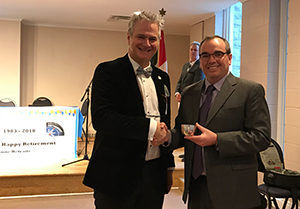
Rear Adm. Shepard Smith presents Denis Hains with a
Jefferson Cup.
Denis Hains, the dominion hydrographer for Canada and director of the Canadian Hydrographic Service, retires from government service this month after 35 years of service. Rear Adm. Smith attended the retirement service in Ottawa presented a token of NOAA’s appreciation, an inscribed Jefferson Cup and a letter from NOAA Acting Administrator, Rear Adm. Gallaudet. Mr. Hains has made immeasurable contributions to Canada’s hydrographic and geodetic capabilities over the years and will be missed for his role representing Canada in bilateral and regional cooperative frameworks for North American and Arctic cooperation. His successor has not been announced. In November 2016, the Canadian Government launched the $1.5-billion (CND)
Oceans Protection Plan, the largest investment ever made to protect Canada’s coasts and waterways, while also growing the economy. The efforts include making navigation safer. For more information, contact
Jonathan.Justi@noaa.gov.

NOAA Ships
NOAA Ship Ferdinand R. Hassler - Alongside in New Castle, New Hampshire.
NOAA Ship Thomas Jefferson - Alongside in Norfolk, Virginia.
NOAA Ship Fairweather - Alongside in Newport, Oregon.
NOAA Ship Rainier - In Portland, Oregon, for its repair period.
Navigation Response Teams
NRT 1 - Team is in Mobile, Alabama. Operations are suspended until the team's training is complete.
NRT 2 - Team is in St. Petersburg, Florida, responding to a U.S. Coast Guard and Port of Tampa request for additional survey work around the Skyway Bridge to support a planned alternate channel for smaller traffic.
NRT 4 - Team is in Galveston, Texas. Vessel crossdeck is complete, boat is survey and response ready.
NRT 5 - Team is in New London, Connecticut, and completed troubleshooting and testing with CSDL's Hydrographic Systems and Technology Branch.
Bay Hydro II - Bay Hydro II is back in the water and is survey and response ready.
Contractor operations
Leidos - Demobbed, acquisition complete.
Oceaneering - Demobbed, acquisition complete.
David Evans and Associates - R/V Preston continues to survey the Mississippi Sound and vicinity.

Awards
Anthony Johnson, NOAA's February Employee of the Month.
Congratulations to
Anthony Johnson who was chosen as NOAA's February Employee of the Month. Anthony’s effort, leadership, technical ingenuity, and follow-through led to the completion of the crucial Coast Survey Disaster Recovery Project. This achievement ensures that Coast Survey can maintain continuity of critical mission operations by performing failover of essential IT infrastructure, computer systems, and applications to our alternate processing site. Anthony also demonstrated strong technical leadership working with other NOS IT partners to establish an external-facing network in Seattle, Washington, allowing all public-facing Coast Survey services to be available under the disaster recovery model, increasing the mission-value of the disaster recovery process. As a result, Coast Survey's ability to protect life, property, and safety of the maritime community will be maintained during adverse events.
Coast Survey Brown Bag
Visualizing Operational Forecast System Data for Mariners - Coast Survey Development Lab has been working to provide operational forecast system (OFS) model forecast data to third party navigation systems manufacturers, such as Rose Point Navigation Systems. These providers have an interest in using these datasets for precision navigation and optimized route planning, as OFS primary forecast parameters include water level, surface currents, temperature, and salinity. Please join us for a brown bag presentation on this project covering OFS model data output on
Wednesday, February 14, at 12:00 p.m. (EST) in room 6836. For more information, contact
Neil.D.Weston@noaa.gov
Detail Opportunity
Coast Survey is seeking an interested and qualified individual for a full-time, six month detail assignment to conduct out-year budget formulation, strategic planning, legislative engagement, and grants oversight for Coast Survey in coordination with the U.S. Integrated Ocean Observing System, National Geodetic Survey, and CO-OPS. The selected person would work with Coast Survey divisions and others in support of the director, deputy director, deputy hydrographer, and chief, Resource Management Staff. This is a great opportunity to learn about NOAA and NOS policy, legislative, and budget formulation activities, and work closely with Coast Survey and NOS management. Applications (includes resume and statement of interest) are due by next Friday, January 26, 2018. For more information, contact
Kathleen.Jamison@noaa.gov.