End of an era: Last of the standards shipped to archives
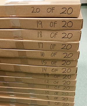
Last 20 boxes filled with chart standards and other historical
documents ready to ship to the National Archives and
Records Administration.
This week, Marine Chart Division’s Nautical Data Branch (NDB) shipped its remaining boxes of current (paper) chart standards to the National Archives and Records Administration. In total, NDB shipped out 86 boxes of chart letters ranging in date from 1923 - 2009; 111 boxes of chart histories ranging in date from 1900 - 2009; and 156 boxes of chart standards ranging in date from 1886 - 2015. NDB began working with NOAA Records Office in October 2013 to archive all of the historical records. Over a four-year period, NDB employees scanned, recorded, and packed the historical chart letters, chart histories, and chart standards. There are a few reasons for the mass exodus of these paper products. With the reconfiguration fast approaching, NDB needed to move the chart standards out of the map file room and empty all of the file cabinets of chart histories and chart letters from the main area. Additionally, NDB maintained the paper chart standard until it moved to a digital chart standard on June 1, 2015. Job well done to
Lance Roddy for leading this project and to
Rolland Gant for all of his help.
Coast Survey attends Miami and Providence boat shows
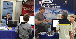
LT Andrew Clos interacts with the public at the Providence
Boat Show and Andy Kampia answers questions at the Miami
Boat Show.
Northeast navigation manager
LCDR Meghan McGovern and
LT Andrew Clos staffed the Coast Survey booth at
Providence Boat Show from February 3-5. Southeast navigation manager
Kyle Ward was joined by
Andy Kampia,
Sam DeBow,
Steve Soherr, and
Kristen Crossett at the
Miami Boat International Boat Show February 16-20. Both shows provided a great opportunity to discuss the products and services that Coast Survey provides with the public. Many visitors were surprised to learn our products are free and that
BookletCharts are available. Attending boat shows helps Coast Survey gain insight into ihow the public is using our products, what services they are looking for, and how we can better meet their needs.
Recommended routes on Great Lakes charts to be updated
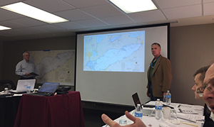
Tom Loeper leads the discussion to update recommended
routes on Great Lakescharts.
Brian Akers and
Tom Loeper, Great Lakes navigation manager, recently attended a working group meeting of Great Lakes captains and shipping industry representatives in Cleveland, Ohio. The working group discussed updates to recommended routes on Great Lakes charts. The recommended routes first appeared on charts about 100 years ago and were recognized as one of the first operational traffic separation schemes to reduce collisions on the entire Great Lakes shipping system. All the routes were added to the paper charts over the last century but there are many inconsistencies such as edge matching issues that need to be corrected before the routes can be accurately depicted on ENCs. Sixty to seventy percent of the routes have no history of when, why, or who added a particular route to the chart. The Great Lakes charts are being loaded into the Nautical Information System through the summer of 2017. The purpose of the working group is to develop system-wide tables of waypoints and courses to accurately navigate using an ENC in an ECDIS. The tables will be added to Coast Pilot 6 and several Canadian Sailing Directions. The recommended routes will be jointly maintained by the Lake Carriers' Association in the U.S and the Canadian Shipowners Association in Canada. Thanks to the efforts of
Steve Soherr, the working group had a large format plot of Lake Erie with about 45 recommended routes and several detailed spreadsheets to work with.
NOAA Hollings scholar returns to NOAA
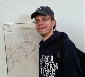
Seth Antozzi visits the Atlantic Hydrographic Branch as part
of an "externship" program.
Recently, Hydrographic Survey Division's Atlantic Hydrographic Branch hosted 2015 NOAA Hollings scholar,
Seth Antozzi, as part of Virginia Wesleyan College’s “externship" program. An externship is an opportunity for students to shadow personnel at a given job without actually working there (as an intern). It provides students with a sense of the work environment and allows them to explore their career interests and goals. The branch had the opportunity to mentor Seth as well as offer him a chance to gain insight to Coast Survey’s nautical chart program. Seth also gained first-hand insight into the branch’s use of geographic information systems. Thank you to
Gene Parker for coordinating the opportunity and mentoring Seth, and to
Jeff Marshall,
Rita Bowker, and
Matt Wilson, for demonstrating their technical skills.

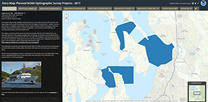
2017 Hydrographic survey season plans
Weekly chart update webpage. One glance will tell you if the
chart in your area has been updated.
One of Coast Survey's biggest tasks during the winter months is to plan hydrographic survey projects for the coming field season. Project managers consider requests from stakeholders such as marine pilots, port authorities, the Coast Guard, and the boating community, and also consider other hydrographic priorities in determining where to survey and when. This year, Coast Survey has compiled a "living"
story map outlining these plans. The story map will be updated as progress is made with each survey project. Read more on our
blog or on the
National Ocean Service website. Kudos to
Patrick Keown and
Leland Snyder for putting the plan and story map together. Thank you also to navigation managers and all of HSD Ops for providing input to the project descriptions and project details.
New process for project lifecycle and portfolio management
Coast Survey is working on a new improved process for project lifecycle and portfolio management. The current SDLC is being streamlined and renamed PPM (Project Portfolio Management). PPM is being designed to be an easier, simpler, streamlined process that will make project management more accessible to everyone in Coast Survey. Projects in the system will be free to be managed as the project manager sees fit, without tying it to specific software or systems. The goal of PPM is to allow greater visibility, support, and communication of projects and tasks throughout the organization.

Staff Updates
Coast Survey welcomes Alexanderia Allison, our new front office administrative assistant. Alexanderia comes to us from NOAA's Climate Program Office and has experience with high-level administrative support, scheduling, and travel coordination. Alexanderia is a graduate of Howard University John H. Johnson School of Communications with a major in legal communication and a minor is sociology. Please stop by the front desk this week to say hello!
The Hydrographic Surveys Division, Operations Branch (OPS) is pleased to welcome Martha Herzog for a four month detail. Martha brings a wealth of hydrographic experience and technical expertise from her role as a Physical Scientist at the Pacific Hydrographic Branch in Seattle, WA. Martha will be working on the 2017 Hydrographic Specifications and Deliverables update, updating the XML schema for the Data Acquisition and Processing, and will work closely with other Project Managers in the Operations Branch to help draft project instructions.
Eric Wallner is stepping up to handle the responsibilities of Acting Chief, Production Branch A (Alaska, and Lakes Superior, Michigan, and Huron) in the Marine Chart Division for all of March and April. He is relieving Brian Akers, who did an excellent job in that role for the last two months.
Awards
Congratulations to ENS Max Andersen, ENS Marybeth Head, Alex Ligon, LT Joseph Carrier, LT Matthew Forrest, RDML Shepard Smith, Kirk Andreopoulos, Michael Peperato, LT Damian Manda, and LT Eric Younkin for being awarded the NOAA Bronze award–the highest honor award granted by the Under Secretary of Commerce for Oceans and Atmosphere, the Bronze Medal recognizes superior performance by federal employees–for rapid integration and deployment of Autonomous Surface Vessels for hydrographic use aboard the NOAA Ship Thomas Jefferson.
Opportunities
Detail as branch chief of the Pacific Hydrographic Branch
Hydrographic Services Division is accepting applications for a detail opportunity as branch chief of the Pacific Hydrographic Branch in Seattle. The expected start date of the 150-day detail is June 5, 2017.
If interested, please contact CDR Ben Evans, chief, Pacific Hydrographic Branch at benjamin.k.evans@noaa.gov.
Full-time university training opportunity at UNH
The Admiral has just announced this year’s competitive training opportunity for graduate training in ocean mapping and hydrography at the NOAA/UNH Joint Hydrographic Center at the University of New Hampshire. This is an excellent opportunity for Coast Survey professionals to develop nationally and internationally-recognized expertise in hydrography.
During the past year, the University of New Hampshire has been effecting a comprehensive update of our ocean mapping curriculum in response to the evolving needs of Coast Survey, feedback from our graduates and their employers, and the major changes in the FIG/IHO/ICA Category “A” Hydrographic Survey Standards of Competence. As part of our update, the Center has added several new faculty members, including Dr. John Hughes Clark, who many know from his role in the Shallow Water Multibeam Course, his research and mentoring successes, and his engaging presentations at hydrographic conferences. Also new to the Center is Dr. Jennifer Miksis-Olds, this year’s winner of the prestigious Medwin Prize in Acoustical Oceanography awarded by the Acoustical Society of America. We are confident that our revised program and our expanded faculty will provide an excellent hydrographic educational experience for our students—and will graduate highly-qualified hydrographers ready to make important contributions to the Coast Survey mission.
If you have questions about the application process, please contact Lorraine Robidoux, deputy chief, HSD, at (301) 713-2702, ext. 122, or lorraine.robidoux@noaa.gov.