ENC and RNC updated and released within a month of receiving third party data
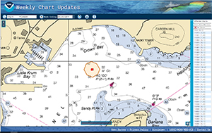
Location of change made to chart 25649.
Up until a few weeks ago, a 31’ foot sounding depicted on chart 25649 was preventing some cruise vessels from using the Little Krum Bay pier in St. Thomas, U.S. Virgin Islands. The U.S. Virgin Islands Port Authority removed pinnacle rock causing the shoal and hired Arc Survey, a private company, to survey the area in early May. This data was sent to Hydrographic Surveys Division’s (HSD) Atlantic Hydrographic Branch (AHB) to determine if the data supported a deeper sounding.
James Miller in AHB reviewed the data and sent a source document to the Marine Chart Division (MCD) where
Kieumy Dinh removed the 31’ sounding and replaced it with a 33’ sounding on the RNC and ENC. This RNC update was released on May 25. This rapid chart update (i.e. published in under a month from acquisition) with third party data demonstrates the fluid teamwork among Coast Survey divisions. Thank you to
Kyle Ward, Southeast navigation manager for facilitating the initial discussions with Arc Survey, the U.S. Virgin Islands Port Authority, HSD, and MCD. For more information on this project contact
Kyle.Ward@noaa.gov.
Atlantic Hydrographic Branch physical scientists attend SonarWiz training
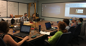
AHB physical scientists attend SonarWiz training.
Physical scientists in AHB took two days of onsite SonarWiz software training from June 13-14. This software training is important as AHB receives volumes of contracted side scan data acquired and processed using the software. The training was a chance for branch physical scientists to understand and learn how to review data collected and processed using SonarWiz. For more information on this project contact
Briana.Welton@noaa.gov.
Coast Survey participates in key international hydrographic meetings
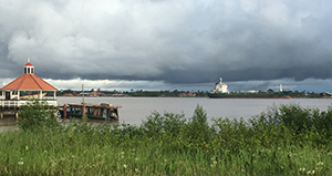
Freighter navigating down the Suriname river from port to
ocean.
Coast Survey represented the U.S. at two international meetings earlier this month in Suriname. At the first meeting, Coast Survey shared news of recent and planned international capacity building efforts. Foremost among these highlights was MCD’s chart adequacy assessment training of approximately a dozen international students each summer and the recent approval and accreditation by the
International Hydrographic Organization of
NOAA’s Category B Competence Training for Nautical Cartography. After the global capacity building review,
RDML Smith (representing the U.S.) and
John Nyberg (representing the MesoAmerica-Caribbean regional hydrographic commission) were joined by approximately 35 other participants from around the world for the 7th annual global hydrographic policy coordination review meeting. During this meeting, participants addressed global coordination of new initiatives including those related to emerging survey technologies and platforms, anticipated establishment in August of a new technical working group dedicated to marine spatial data within the United Nations, global ocean mapping initiatives, and new leadership directions of the IHO as the new leadership and governance structure begins to take shape. Dr. Parry Oei of Singapore agreed to continue chairing the global coordination committee and Thomas Dehling of Germany agreed to continue chairing the capacity building committee. The new Secretary General-elect of the IHO, Mr. Jonas Mathias, will assume his new position on September 1. The next three years promise many exciting new developments in the IHO for the U.S., NOAA and the Office of Coast Survey. Please stay tuned! For more information on this project contact
Jonathan.Justi@noaa.gov.
Project Update: Aimed Stakeholder Interaction and Survey Tool (ASIST)
Draft ASIST logo.
Designed as a re-imagining of IDMS (Inquiry and Discrepancy Management System), the ASIST project has taken the excellent functionality of IDMS, added a much needed geospatial component to the data, and added an improved user interface. The system will also act as a replacement for our yearly customer survey and hopefully provide for a wider demographic of responses to important questions, helping Coast Survey grow as a customer-driven organization. Once completed, the project will live in Navigation Services Division for management. The project manager for development is
Georgios Britzolakis from CSDL's Geospatial Application Development Branch. If you have any questions or thoughts about the project, please contact
Scott.Sherman@noaa.gov.
Successful processing of outside source data from the Arctic
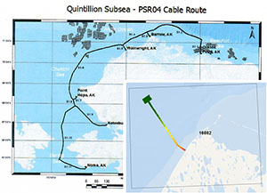
Location of Quintillion data.
Recently, Coast Survey received Quintillion multibeam survey data collected during the installation of a subsea cable in the Arctic intended to bring information services to the small communities there. RDML Smith uses this project as an example when explaining Coast Survey’s policy on External Source Data. Processing Quintillion data was a big lift for the Marine Chart Division. Thank you to
Noel Dyer for your hard work on this project and to
Allison Wittrock for your leadership in making the data processing possible.

NOAA Ships, Navigation Response Teams, and Contractors:
NOAA SHIP
FAIRWEATHER
NOAA Ship
Fairweather has been diligently
working in Tlevak Strait, west of Prince of Wales Island, Alaska. The crew was able to take advantage of the shoreline windows and conduct work with laser scanners. This is the last week on this project before heading to Kodiak to begin their mid-season repair period.
NOAA SHIP
RAINIER
NOAA Ship
Rainier has been continuing its excellent
work in and around Chiniak Bay, outside of Kodiak, Alaska. The ship has decided to utilize
Eric Younkin’s automated processing tool, for one of the sheets on their project. Additionally, kudos to
ENS Jennifer Kraus on becoming Hydrographer In-Charge (HIC) qualified.
NOAA SHIP
FERDINAND R. HASSLER
NOAA Ship
Ferdinand R. Hassler is alongside in Baltimore, Maryland, for a scheduled repair period.
NOAA SHIP
THOMAS JEFFERSON
NOAA Ship
Thomas Jefferson is alongside in Norfolk, Virginia. Repairs to the ship are on-going.
NAVIGATION RESPONSE TEAMS
NRT1 - Will welcome two new hires this summer,
Alex Ligon on June 11 and
Joshua Bergeron on August 6. Welcome aboard!
NRT2 - Commenced and completed operations in St. Andrew’s Sound, Florida.
NRT3 - Suspended operations until new hires are brought on board.
Timothy Wilkerson is augmenting on NRT5 and
Bay Hydro II.
NRT4 - Continues to get staffed up and ready to go, tending to needed maintenance on both vessel and trailer.
NRT5 - Commenced operations with
Bay Hydro II on the Hudson River project.
NRT6 - Suspended operations through FY17.

Staff Updates
Thank you to Andy Kampia for serving as NSD’s acting Customer Affairs Branch (CAB) chief while Rachel Medley has been on an extended detail as the acting Deputy Hydrographer. Andy’s detail ends on June 30. Christina Fandel has been selected to serve as acting CAB chief starting July 1. Christy comes to NSD from the HSD Operations Branch were she has been managing projects for both NOAA ships and contractors. Additionally, she has led the development of the hydrographic health model. She earned her Category-A Hydrographic Certificate along with her masters degree in Earth Sciences & Ocean Mapping from the University of New Hampshire.
PS Melody Ovard is leaving AHB on June 22 to accept a GIS position with Snohomish Country in Everett, Washington. Melody primarily worked on survey acceptance reviews and provided field support to many NOAA ships during her time at AHB. She will be missed, but we wish her fair winds and following seas as she pursues her career and life goals.