Sneak peek of “Women in the NOAA Corps” shown at NOAA Corps Centennial Dining Out
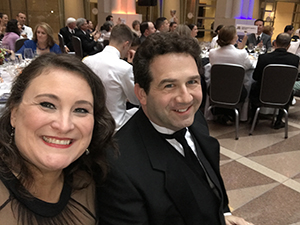
Crescent Moegling and Bob Schwartz attend the NOAA
Officer Corps Dine Out.
Crescent Moegling, Northwest navigation manager,
Timi Vann, from the National Weather Service, and
Bob Schwartz, from NOAA Communications, previewed a segment of their forthcoming film, “Women in the NOAA Corps” at the NOAA Corps Centennial Dining Out on Saturday, March 20. The segment called, “One Word” shows the film subjects responding to the question “In one word can you describe what gift the NOAA Corps has given you?” The entire film highlights eight women along with the first NOAA Corps Director Admiral Harley Nygren, and former NOAA administrator Dr. Kathryn Sullivan. This project was the result of the
Preserve America Initiative funding along with support from Coast Survey, NOAA Communications, and the NOAA West Regional Collaboration Team. The team has been working for over a year on this film which they hope to release late summer 2017 and submit it to a few film festivals. The file will be available for viewing online when it is released and there are plans to host a viewing in Silver Spring. Contact
Crescent.Moegling@noaa.gov for information on their forthcoming film.
Coast Survey attends National Maritime Day event in Baltimore
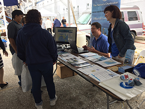
Steve Soherr and Kathy Carpenter share some of Coast
Survey's products at Pier 13 in Baltimore.
Kathy Carpenter, Marine Chart Division (MCD),
Martha Bakry, MCD,
Lynne Mersfelder-Lewis, Navigation Services Division, and
Steve Soherr, Chesapeake and Delaware Bay navigation manager, participated in the National Maritime Day event at Pier 13 in the Canton area of Baltimore Harbor. A variety of maritime related organizations including sea cadets, Maryland Department of Natural Resources, Maryland Police, Maryland Fire and Rescue, U.S. Coast Guard (USCG), historic ships and crew, Maryland Port Adminstration, and pilots, had tables at the event as well as boats to tour. The first nuclear merchant ship,
USS Savannah, is permanently moored at Pier 13 and was the highlight of the event. Coast Survey engaged with the general public, demonstrating the website including pages such as the Chart Locator, Booklet Charts, Historical Charts, Automated Wreck and Obstruction Information System, and more. The team found that very few event attendees were aware of our products and were pleasantly surprised when they saw them. For information about Coast Survey's participation in this event, contact
Steve.Soherr@noaa.gov.
Coast Survey helps map deep coral gardens in the Channel Islands National Marine Sanctuary
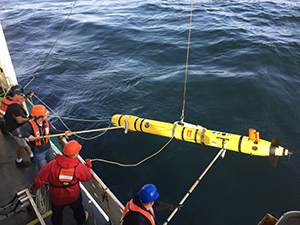
Joao Alves, Nicholas Morgenstern, John Doroba, and
Brendan Garvey deploy AUV off NOAA Ship Bell M. Shimada.
Rob Downs and
John Doroba, Coast Survey Development Lab (CSDL), and
Juliet Kinney, Integrated Ocean and Coastal Mapping at the University of New Hampshire, participated in a multi-disciplinary project aboard NOAA Ship
Bell M. Shimada to explore and map the deep coral gardens in the Channel Islands National Marine Sanctuary. The project included participation from Office of National Marine Sanctuaries, National Centers for Coastal Ocean Science, and Marine Applied Research and Exploration (MARE). The purpose of the project was to fill gaps in the existing bathymetry data using both the shipboard mapping sonar system and Coast Survey’s REMUS-600 autonomous underwater vehicle (AUV); collect water column data utilizing the shipboard fisheries sonar to assess abundance and distribution of fishes; and explore, identify, and characterize fish and deep sea coral communities using a remotely operated vehicle. Coast Survey personnel operated the REMUS-600 AUV on seven overnight missions of durations up to 14 hours in depths reaching over 1500 feet and acquired over 147 linear nautical miles (20 square nautical miles) of high-resolution bathymetry. Juliet Kinney was part of the shipboard mapping team. For information on Coast Survey's participation in this project, contact
Rob.Downs@noaa.gov.
Hurricane season prep continues on the Gulf coast
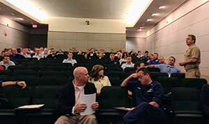
CAPT Crocker addresses participants of the hurricane
season prep meeting in New Orleans, LA.
This week,
CAPT Jim Crocker, chief of Navigation Services Division,
Tim Osborn, eastern Gulf coast navigation manager, and
Alan Bunn, western Gulf coast navigation manager, attended the Gulf Intracoastal Canal Association Joint Hurricane Team (GICA JHT) annual hurricane season prep meeting in New Orleans, Louisiana. Coast Survey was joined by the National Weather Service who shared their latest season predictions and tools. Coast Survey participates in this yearly hurricane preparedness meeting to build relationships and coordinate emergency response capabilities with agencies such as USCG, U.S. Army Corps of Engineers (USACE), and port authorities spanning from Panama City, Florida, to south Texas. While in the area, CAPT Crocker toured the NOAA National Data Buoy Center where NRT 1 is homeported as well as visit Senator Kennedy’s (Louisiana) staff office. Contact
Tim.Osborne@noaa.gov for more information.
Highlights from U.S. Coast Guard District 7 Hurricane Exercise
For Kyle Ward, Southeast navigation manager, the USCG District 7 Hurricane Exercise (HURREX) felt more realistic coming just seven months after Hurricane Matthew ravaged the East Coast last October. The week-long exercise involved USCG units from Puerto Rico, U.S. Virgin Islands, the entire Florida Peninsula, Georgia, South Carolina, as well USACE and NOAA survey units. Kyle spent a good part of the HURREX meeting coordinating with the Maritime Transportation System Recovery Unit lead, in-coming captain of the port for Sector Charleston CAPT (Select) Brian Falk, the new chief of survey from the Savannah USACE district, and the chief of survey from the Charleston USACE district. Kyle reports that these in-person visits pay great dividends during an actual disaster response. For more information on HURREX, contact
Kyle.Ward@noaa.gov.

NOAA Ships, NRTs, and Contractors:
NOAA SHIP FERDINAND R. HASSLER
NOAA Ship Ferdinand R. Hassler is alongside U.S. Coast Guard Curtis Bay Shipyard for a scheduled repair period. Tentative completion is late July.
NOAA SHIP RAINIER
NOAA Ship Rainier continues multibeam acquisition on sheets H12998, H12999, H13000 and completed multibeam acquisition on sheets H12996 and H13000.
Rainier also conducted helo evacuation drills with USCG on Tuesday and Wednesday, May 22-23. They will arrive at Kodiak city pier on Saturday, May 27, to hold an open house during the Crab Fest event.
NOAA SHIP FAIRWEATHER
We've got some good news, Fairweather is finally underway! First up on the docket is a compass adjustment, followed by ship patch test and then sonar acceptance for the new EM2040s. To accomplish these tasks the crew will be joined by Glen Rice and Eric Younkin (specifically for sonar acceptance) from CSDL's Hydrographic Systems and Technology Branch, Tyanne Faulks and Jessica Murphy (to observe the sonar acceptance and provide general support) from Hydrographic Surveys Division's (HSD) Pacific Hydrographic Branch, and Christina Belton (to experience her first underway on a NOAA ship and share news from Silver Spring) from HSD's Operations Branch. Representatives from Kongsberg will also be aboard for the first few days of sonar acceptance to make sure the systems are operating as intended.