NOAA Ship Thomas Jefferson successfully tests new wireless system that aids remote vessel operation
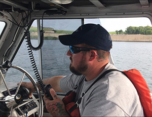
Able Bodied Seaman Pat Osborn stands by to take control of
Thomas Jefferson's launch while communicating the traffic
situation to the ship. The launch autopilot system and survey
systems interfaced to enable remote steering while the
coxswain retained control of the engine.
NOAA Ship Thomas Jefferson successfully tested a new wireless networking system while working in the Approaches to Houston/Galveston and around Puerto Rico during the 2018 field season. This new system connects the ship and its two hydrographic survey launches, providing a level of wireless connectivity previously unobtainable with traditional wireless communications systems. NOAA anticipates this will increase unmanned system productivity while conducting hydrographic surveys.
Thomas Jefferson accomplished two important milestone while testing this system, including the transfer of real-time data from a launch working five nautical miles from the ship and the collection of data while remotely operating one of the launches. Data collected during the demonstration was equivalent to data collected during a traditional launch day and will be submitted as part of survey H13140.
Thomas Jefferson even found a wreck during the first day of remote launch operations. Visit our
blog for the full story. For more information contact Lt.
Charles.J.Wisotzkey@noaa.gov.
NOAA Ship Rainier investigates deep offshore areas of the California coast with USGS and BOEM
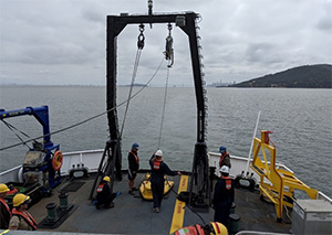
With the help of USGS scientists, Rainier crewmembers
practice deploying the Edgetech Sub-bottom 512 Chirp
profiler, a piece of equipment supplied by the USGS team.
Credit: Dr. Maureen Walton, USGS
NOAA Ship Rainier spent September completing a multi-leg, joint collaboration project investigating deep offshore areas of the southern California coast. The U.S. Geological Survey (USGS) and Bureau of Ocean Energy Management (BOEM) partnered with NOAA to support a month-long mission to collect geophysical data along the outer continental shelf of California where the area in question features a number of different geologic structures and processes. Scientists will use this information to develop a greater understanding of the “geohazards” like submarine landslides and earthquakes in this region. Bathymetric data from this project will be further used to update NOAA’s nautical charting products in the area. This project supports the Expanding Pacific Research and Exploration of Submerged Systems (EXPRESS) campaign which comprises a large and diverse team of federal and non-federal partners targeting deepwater areas off of the U.S. Pacific coast.
Visit our
blog for the full story. For more information contact
Airlie.Pickett@noaa.gov.
Second Council meeting of the International Hydrographic Organization held in London
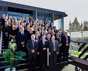
IHO council meets in London.
Rear Adm. Shep Smith, director of Coast Survey, chaired the
second council meeting of the
International Hydrographic Organization (IHO) in London from October 9-11. The U.S. delegation led by Coast Survey's
John Nyberg, is one of 38 member states represented on the council. Two of the major tasks before the Council this year were to confirm the way forward on a new strategic plan for the organization of 89 member states and to begin outlining the production and delivery of new nautical products and services using the new hydrographic data model (S-100). The council also addressed the role of the hydrographic community in the development of the
Seabed 2030 global initiative. The council was established in November 2016 and functions much like a corporate board of directors, overseeing performance management and the business side of the IHO. For more information contact
Jonathan.Justi@noaa.gov.
Navigation Response Teams
All teams are processing data and are on scheduled down time for rest and routine maintenance following Hurricane Michael.
Bay Hydro II - Vessel is entering a contracted repair period.

Staff Updates
Rachel Medley, Navigation Services Division's Customer Affairs Branch (CAB) chief, is on detail as deputy director of the Office of National Marine Sanctuaries for the next few months. During this time,
Lucy Hick, technical advisor for Navigation Services Division, will be the acting CAB chief.
IDP training update
If you attended the IDP Training session on September 24 and want to review the speakers' presentations, or are curious about the session, the IDP presentation slides and videos are now
available. Thank you again to the speakers for their contributions, and stay tuned - we are actively planning IDP training at the branches in 2019.
International Program detail opportunity
The deadline to submit a statement of interest for the international specialist detail position in the Coast Survey staff office is October 31. The position is a one year assignment anticipated to start on or about November 1, with exact start and end date negotiable based on the needs of the host division and detailee. Please note that you must have supervisory approval to apply for this opportunity. Contact
Jonathan.Justi@noaa.gov for details.
Awards
Congratulations to
Jay Nunenkamp (Coast Survey staff) who was selected as a 2018 Employee of the Year. This award recognizes significant contributions to NOS programs and exceptional and sustained effort toward accomplishment of NOS missions. Jay is being honored for substantially advancing Coast Survey and NOS environmental compliance activities.
Congratulations to
Andre Van der Westhuysen (National Weather Service) who was nominated by Coast Survey and selected for the NOS Peer Recognition “Rafting Award.” This award encourages coordination between NOS offices and centers, emphasizes integration across programs, and provides NOS employees the opportunity to express their appreciation to a colleague in another NOS program office or NOAA line office. Andre is being honored for his expertise in making harmonized, high-resolution operational wave model forecasts available for precision navigation use in the Port of Long Beach.