
September 27, 2017
Hello Coast Survey,
I am honored to take up the pen for this edition of the bi-weekly newsletter. A special thanks to Rear Adm. Smith for the opportunity to discuss my new role as the Office of Coast Survey Geospatial Data Program Manager.
Coast Survey generates a wide variety of geospatial data for use inside and outside of our office. The overarching goal of the Coast Survey Geospatial Data Program is to ensure that our geospatial holdings are used by the widest audience possible. In the short term, a top priority of mine will be to increase communication between divisions, programs, line offices, and agencies. NOAA is a data centric organization and it is essential that Coast Survey increase collaboration—internally and externally—to acquire the best solutions to simple and complex geospatial problems. Another top priority will be to increase data discoverability. The number one question I have received since I accepted this position is, "Where can I find certain datasets?" Coast Survey has made great strides in leveraging the power of ArcGIS Online through both Coast Survey GIS Portal and the NOAA Geoplatform, but with that comes the challenge of metadata management. Small changes in metadata management will lead to large improvements to data discoverability.
Integration across divisions is something I believe we all strive for and that is why I am taking that on as a long-term goal. Coast Survey’s core mission, to provide nautical charts, relies solely on collaboration between divisions. Because of this, I believe it is crucial that we look at our processes, especially those with geospatial aspects, from a holistic, enterprise approach. Coast Survey employees should be able to use and share data seamlessly across the organization without duplication. This can be achieved by implementing data governance, utilizing current infrastructure, and eliminating gaps in cross-divisional processes.
In closing, I want to let everyone know that I am here to assist with any geospatial questions, concerns, or issues you may have. I am excited to take on this role and look forward to working with each of you in a combined effort to make GIS an integral part of Coast Survey.
Thanks,
Patrick Keown
Geospatial Data Program Manager, Office of Coast Survey
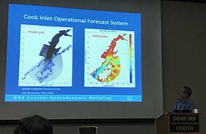
Oceans 17, a premier international conference sponsored by the Marine Technology Society and IEEE Oceanic Engineering Society, was held in Anchorage, Alaska, from September 18-22, 2017. The conference was attended by nearly 2,000 scientists, engineers, and marine professionals from all over the world. The theme for the conference, “Our Harsh and Fragile Ocean,” brought experts together from industry, academia, and several governmental programs to continue tackling some of the most challenging problems in coastal environments and marine science. The technical program covered many topics, but those of interest to NOAA were on instrumentation and observing sensors, vehicle navigation, the Arctic, seafloor mapping, marine partnerships, the Atlantic Ocean Research Alliance, and autonomous vehicles. Coast Survey had three participants attend the confernece, Capt. Edward Vandenameele, chief of the Coast Survey Development Lab, Dr. Lei Shi, and Dr. Neil Weston. Dr. Shi gave two presentations on the Cook Inlet Operational Forecast System in addition to joining his Coast Survey colleagues for several meetings with local and regional stakeholders. For more information, contact .Neil.d.Weston@noaa.gov.
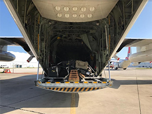
NOAA’s mobile integrated survey team (MIST) traveled via USCG C-130 aircraft and USCG Cutter Venturous to San Juan, Puerto Rico, and arrived on Saturday, September 23. The MIST completed survey work in the Port of Arecibo, an important fuel and chemical port, and will return to the continental United States on Thursday, September 28. NOAA Ship Thomas Jefferson is enroute from Port Everglades, Florida, to Puerto Rico and will arrive on Thursday, September 28. Upon arrival, Thomas Jefferson will drop supplies for the National Weather Service and the USCG anticipates they will begin hydrographic survey operations in Christensted, St. Croix.
NOAA ship, NRT, and contractor operations
Weekly Hydro Ship Activity Report: Week of September 17
NRT 1 - Team members from NRT 1 augmented response efforts for Hurricanes Harvey, Irma, and Maria.
NRT 2 - Completed Hurricane Irma response surveys and was standing by last week for potential response to Hurricane Maria.
NRT 4 - Completed Hurricane Harvey response surveys. Wes Rowland augmented on NRT 5 during Hurricane Irma response transporting their boat to and from the response site. Erin Diurba also augmented on NRT 5 during Hurricane Irma response and transported a towing vehicle from the Disaster Response Center in Mobile, Alabama, to the response site and back. Both Wes and Erin spent time on the NRT 5 boat driving survey lines. NRT 4 will host an open house in Galveston, Texas, on October 13, 2017.
NRT 5 - NRT 5's Eli Smith assisted MIST during Hurricane Harvey response. Michael Bloom assisted with MIST during Hurricane Irma response and is currently with MIST for Hurricane Maria response. Crossdeck to new vessel was completed prior to response to Hurricane Irma. The team is now in New England.
MIST - Hurricane Harvey crew: Mike Annis, Eli Smith (NRT 5), Joshua Bergeron (NRT 1); Hurricane Irma crew: Mike Annis, Lt. Cmdr. Jon French (NRT 1), John Duroba (HSTB), Michael Bloom (NRT 5); Hurricane Maria crew: Mike Annis, Lt. Cmdr. Jon French (NRT 1), John Duroba (HSTB), Michael Bloom (NRT 5).
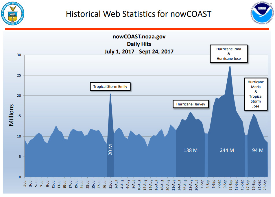
The record breaking hurricane season so far this year has brought a record breaking number of nowCOAST hits. Combined hits during Hurricane Harvey and Irma is the largest we have experienced. Click to view a larger image.
10/2 - NOAA Corps officers' promotion ceremony at 10 a.m. in the NOAA Science Center, Silver Spring
10/5 - NOAA Industry Day at the Annapolis Boat Show
10/5-10/9 - Annapolis Boat Shows
10/17-10/19 - IHO Council meeting

