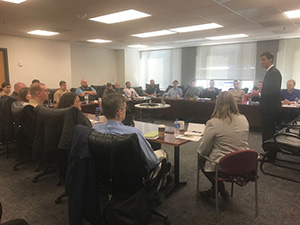
New forms make it easier to provide nautical chart updates of U.S. Army Corps of Engineers permitted projects
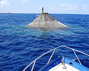
A submersible aquaculture cage sitting on the water for
cleaning and inspection. Coast Survey's updated Artificial
Reef/Aquaculture form allows the USACE to report the status
of aquaculture and artificial reef permitted activities that
may affect navigation.
NOAA’s Office of Coast Survey updated two forms to improve voluntary project status reporting by the U.S. Army Corps of Engineers (USACE). The
Permit/Public Notice form and the
Artificial Reef/Aquaculture form have been revised to clarify the important information necessary to keep accurate charts. They are modernized with semi-automated reset, attach, submit and save function buttons, "fillable" fields, and are now feature the latest PDF viewer/editor software. The Permit/Public Notice form pertains to USACE permitted construction, maintenance and dredging projects on or near navigable waterways to include chartable features, whereas the Artificial Reef/Aquaculture form should be used to update the status of any USACE permitted reef or aquaculture activity. Completed forms may be e-mailed to ocs.ndb@noaa.gov. For more information, contact
Tara.Wallace@noaa.gov.
Coast Survey navigational products and services shared at the Miami Boat Show
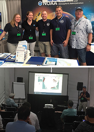
Rachel Medley, Kristen Crossett, Mike Gaeta, Kyle Ward,
and Rear Adm. Sam DeBow (NOAA ret.) in the NOAA booth
at the Miami Boat Show (top image). D. Neil Weston presents
during a seminar at the boat show (bottomm image).
Dr. Neil Weston, technical director of Coast Survey Development Lab,
Rachel Medley, chief of the NSD's Customer Affairs Branch,
Mike Gaeta, Marine Chart Division,
Rear Adm. Sam DeBow (NOAA ret.), Lynker Technologies, and
Kristen Crossett, Coast Survey communications specialist, joined southeast navigation manager
Kyle Ward at the
Miami Boat International Boat Show February 15-19. The boat show provided a great opportunity to discuss with the public the products and services that Coast Survey provides. Many visitors were surprised to learn our products are free and that BookletCharts are available. Attending boat shows helps Coast Survey gain insight into how the public is using our products, what services they are looking for, and how we can better meet their needs. While at the boat show, Dr. Weston gave a seminar entitled, “Visualizing Data for Mariners,” providing information about NOAA’s ongoing initiative to provide modelled water level, surface current, sea surface temperature, and salinity forecast data in a widely useable format. For more information, contact
Kyle.Ward@noaa.gov.
Coast Survey leadership attends the South West Pacific Hydrographic Commission meeting
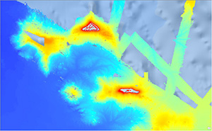
Kingman Reef and Palmyra Atoll are currently charted from
WWII vintage data. Coast Survey will begin the process of
updating these charts using multibeam sonar data, as seen
here.
Rear Adm. Shep Smith, supported by
Capt. Lowell (NOAA ret.) and
Mr. David Anderson, National Geospatial-Intelligence Agency, and
Lt. Cmdr. Russell Quintero, NOAA, recently attended the 15th Meeting of the
South West Pacific Hydrographic Commission (SWPHC) in Nadi, Fiji. The reinvigorated U.S. presence was timely as the region is at the center of many of the Coast Survey’s activities and advancements, such as satellite-derived bathymetry, external source and crowd source bathymetry, Seabed 2030, and collaboration and coordination with partner agencies. There is strong engagement and support between the many Large Ocean States in the SW Pacific and the Primary Charting Authority (PCA) nations responsible for electronic navigational chart (ENC) production. The SW Pacific is emerging as a hotbed of innovative mapping technologies. In particular,
France’s naval hydrographic and oceanic service and
Land Information New Zealand both showed impressive efforts in the application of satellite-derived bathymetry, and the
Royal Australian Navy was praised by the cruise industry for their use of bathymetric ENCs to facilitate access to previously inaccessible ports of call. An initial internal review shows that the U.S. has both the need and the capacity to improve the charts in our areas of responsibility and to share what data we can with other PCAs in the region. Coast Survey will be embarking on an update of our charting in the region over the next 12 months, leveraging both satellite-derived bathymetry and the external source data available in the region at
National Centers for Environmental Information and elsewhere. This new hydrographic data will be incorporated in the charts to improve them, and in some cases, will represent the first updates since WWII.
For more information, contact
Russell.Quintero@noaa.gov.

NOAA Ships
NOAA Ship Ferdinand R. Hassler - Underway and surveying the Approaches to Chesapeake Bay.
NOAA Ship Thomas Jefferson - Alongside in Norfolk, Virginia.
NOAA Ship Fairweather - Alongside in Newport, Oregon.
NOAA Ship Rainier - Alongside in Newport, Oregon.
Navigation Response Teams
NRT 1 - Team is in Stennis Space Center, Mississippi. Boat is survey and response ready.
NRT 2 - Team is in Fernandina Beach, Florida. Boat is survey and response ready.
NRT 4 - Team is in Galveston, Texas. Boat is survey and response ready.
NRT 5 - Team is in New London, Connecticut. Boat is survey and response ready.
Bay Hydro II - Bay Hydro II is survey and response ready.
Contractor Operations
Leidos - Demobbed, acquisition complete.
Oceaneering - Demobbed, acquisition complete.
David Evans and Associates - Demobbed, acquisition complete.
Staff Updates

Gina Digiantonio.
Gina Digiantonio is excited to join the Coast Survey team as a communications specialist contractor. Gina recently completed the Sea Grant Knauss Fellowship with the U.S. Department of the Interior’s Office of Policy Analysis, where she served as an ocean policy and communications specialist. Prior to working in the federal government, Gina researched the genetic diversity of seagrass populations for her master’s degree in environmental sciences from the University of Virginia. She obtained her bachelor’s degree in biology from Drake University. She looks forward to spreading the word of Coast Survey’s work to internal and external stakeholders through blogs, social media posts, newsletters, and more.