Coast Survey map accompanies Obama announcement and press release
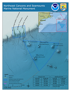
Coast Survey cartographer Leland Snyder used several
data sources to create this map of the Northeast Canyons
and Seamounts Marine National Monument.
On September 15,
President Obama announced the designation of the first marine monument in the Atlantic Ocean, Northeast Canyons and Seamounts National Monument. Coast Survey's own
Leland Snyder (MCD) created the incredible map that accompanied the joint press release from NOAA and the Department of Interior. The map shows the two units of the monument (canyons and seamounts), an overview of the NE and EEZ, and a table of unit coordinate boundaries. There is a long history of NOAA surveying the Northeast Canyons and Seamounts area as explained in an essay by NOAA historian
Capt. Albert “Skip” Theberge, Jr., NOAA (retired). Visit our
blog for the full story.
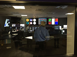
Pacific Hydrographic Branch hosts NOAA leadership
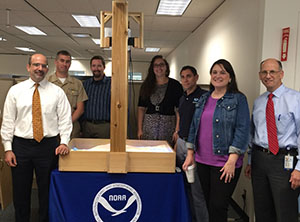
Benjamin Friedman (DUS-O), CDR Ben Evans, Peter
Holmberg, Lorraine Robidoux, Mark Seiler (CFO), Crescent
Moegling, Zachary Goldstein (CIO) surround the sandbox at
Coast Survey’s Pacific Hydrographic Branch.
It’s not every day that NOAA leadership heads out west. Last week,
Benjamin Friedman, deputy undersecretary for operations,
Zachary Goldstein, NOAA’s chief information officer, and Mark Seiler, NOAA’s chief financial officer, visited Coast Survey’s Pacific Hydrographic Branch (PHB). Coast Survey staff provided briefs on charting coverage, PHB’s three general mission focuses of
OMAO ship support, Survey Acceptance Review (SAR), and HCell compilation, and other topics including survey assets, emerging technologies, stakeholder engagement, and hands-on demonstrations of survey acceptance review and HCell compilation processes. Special thanks to
CDR Ben Evans for leading the effort and
Lorraine Robidoux,
Peter Holmberg,
Toshi Wozumi,
LT Charles Wisotzkey,
Crescent Moegling,
Jessica Ramsay, and
Fernando Ortiz for their support.
Extending collaborations with NOAA and USGS partners
The Space Weather Prediction Center was one of the stops
at the NOAA facility in Boulder, Colorado.
Last week
Joel Harrington (MCD),
Kurt Nelson (CSDL), and
Neil Weston (CSDL) visited several groups at the NOAA facility in Boulder, Colorado, to engage in technical discussions and demonstrations. Meetings covered the development of a bathymetric database, GIS software, database advancements, collecting, analyzing, and archiving bottom samples, external data sources, and gridded digital elevation models. The team also toured several labs and had a detailed discussion about
Science on a Sphere, exploring the possibility of displaying hydrographic and other time-dependent datasets using Science on a Sphere technology. While in Colorado, the team visited the USGS Technical Center in Denver, to discuss lifecycle management, change detection algorithms, and how that agency uses ArcGIS server and workflow manager to handle very large geospatial datasets and information. They also discussed an application program interface (API) known as ScienceBase which allows multiple users to catalog, manage, share and interact with the datasets the agency manages. Trips like this allow Coast Survey to develop new and extend existing collaborations, helping to develop more efficient operations down the road.
Coast Survey Development Lab (CSDL) and CO-OPS hosts ocean model workshop
CSDL and CO-OPS hosted the annual Finite Volume Community Ocean Model (FVCOM) workshop September 13-14. FVCOM is one of the hydrodynamic models we use for operational coastal ocean modeling. Changsheng Chen and Bob Beardsley, FVCOM developers from the University of Massachusetts in Dartmouth, visit NOAA annually for this workshop to coordinate closely with NOAA modelers on FVCOM model applications that are being developed, tested, and transitioned to operations at NOAA. Coast Survey attendees included the Coastal Marine Modeling Branch and Tom Loeper. Personnel from CO-OPS, the Great Lakes Environmental Research Laboratory, NWS’ Office of Water Prediction, and NWS’ Meteorological Development Laboratory also participated in the workshop. Thank you to Frank Aikman, Ed Meyers, and Pat Burke (CO-OPS) for your hard work coordinating this workshop.

Navigation Services:
“Temporary non-maintained anchorage” established at entrance to Galveston Bay -
Alan Bunn, navigation manager, has been working with the Lone Star Harbor Safety Committee (LSHSC), Anchorage Sub-Committee for many years in an attempt to establish an anchorage area for shallow draft vessels in the vicinity of Bolivar Roads (entrance to Galveston Bay). Establishing an anchorage will free up room in the deep draft anchorages and significantly alleviate congestion. This will improve safety of navigation, and will have a significant cost savings for the deep draft industries that currently have to anchor offshore when the Bolivar Roads anchorages are full. Recently, a new survey request was received from the LSHSC Anchorage Sub-Committee for areas that were surveyed in 2010 by NOAA Ship Thomas Jefferson and 2013 by NRT 4. Michael Davidson, Navigation Response Branch operations manager, retrieved these prior surveys from NCEI, along with the preliminary data from NRT4’s current surveys and determined how frequently the depths in the proposed anchorage area change, and to monitor the migration of large sand waves through the area. The results of this analysis were presented to the sub-committee and the areas under consideration were narrowed to one primary location. Plans were put in place to pursue a "temporary non-maintained anchorage" just inside the jetties on the south side of the channel. The efforts of all parties involved have expedited a potential solution to the long standing problem of overcrowding in the Bolivar Roads anchorages and minimized the time and resources necessary to do so. Efforts to establish a permanent, maintained anchorage will continue.
NOAA Ships, NRTs, and Contractors:
NOAA SHIP FAIRWEATHER
Remains at Vigor Shipyard in Seward, Alaska, for repairs. Final reviews of West Prince of Wales Island surveys have been completed and are nearing submission to PHB.
NOAA SHIP THOMAS JEFFERSON
NOAA Ship Thomas Jefferson has concluded this year's drydock maintenance and repair period at the USCG Yard and is back in the water. Some highlights of the ship's resulting improvements include: (1) A new sonar transducer suite that includes Kongsberg EM710 and EM2040 multi-beam echosounders. Among some of the most technologically advanced in the world, these sonars will enable Thomas Jefferson to more efficiently than ever acquire high resolution bathymetric data of the sea floor for updating NOAA's nautical charts. They also enable the ship to pursue fisheries-related missions such as bottom habitat mapping, making Thomas Jefferson a more "hybrid" scientific research platform. (2) A new electronic chart display and information system (ECDIS) and radar set that meets globally-recognized electronic requirements for safe navigation, and enables more real-time comparisons between collected data and published nautical charting data. (3) Modification of the ship's fuel, ballast, potable, and waste water tank systems. Thomas Jefferson can now operate more efficiently in environmentally sensitive marine areas (such as close to shore, within bays, or around marine sanctuaries) with increased potable and waste water holding capacity.The ship's planned sailing date is October 3.
NOAA SHIP RAINIER
Continues survey operations along the north coast of Kodiak Island, Alaska.
NOAA SHIP FERDINAND HASSLER
Continues survey operations in the approaches to Wilmington, North Carolina. The ship will break operations to transit for a scheduled Charleston, South Carolina, inport the evening of Thursday Sept. 29.
Bay Hydro II
Returned to Solomons, Maryland. They will start conducting a survey in the Central Chesapeake Bay, OPR-E349-BH2-16. They are processing the data they acquired from the Hudson River project.
NRT 1
During August the Mobile Integrated Survey Team (MIST) System was deployed to Mobile, Alabama, to allow NRT 1 the opportunity to conduct training and testing of the MIST system to remain response ready in the event of a hurricane or storm.
NRT 2
Conducting a survey in the Fernandina Beach, Florida, area (northwest of Jacksonville).
NRT 3
On Sept. 15, NRT3 finished surveying two response surveys in the Columbia River. The first response was to verify depths and identify any obstruction in the Cottonwood Anchorage area. A vessel dragged anchor and struck something with its propeller in the vicinity of 46-03.75N, 122-53.35W while repositioning the ship. The second area was near Skamokawa, Washington. During a grounding investigation, discrepancies between charted soundings and current USACE singlebeam data were noted in the general area. The team was assigned to verify the depths. NRT3 is processing the data of these two surveys and should be submitted to PHB soon. Preliminary reports and data have been given to Navigation Manager Crescent Moegling for dissemination to constituents.
NRT 4
On project conducting survey ops in the approaches to Galveston, Texas, region.
NRT 5
Continues to survey on the Hudson River project south of Kingston, New York.
NRT 6
Wrapping up survey processing on the Suisan Bay, California, project.
E-Trac
Continues to survey and process the area Offshore of SW Pass approaching the Mississippi River in Louisiana.
Ocean Surveys, Inc.
Continues to survey and process the approaches to Atchafalaya Bay off the coast of Louisiana.
Fugro
Continues to survey and process in the area of Penobscot Bay off the coast of Camden, Maine.
David Evans and Associates
Continues to survey and process in the area of Breton and Chandeleur sounds off the coast of Louisiana and Mississippi.
Leidos
Continues to process the surveys in the area of Sabine, Louisiana.

Thank you to IT for support and extra hours during weekend power shutdown
On Friday, September 9, there was an electrical arcing event on the M2 level of the parking garage under SSMC3 in Silver Spring. This caused fluctuating power outages, and eventually, a full building power outage that continued through that weekend. As this was a sudden event, Coast Survey IT was unable to shut down servers until the following morning, when building access was granted on Saturday, September 10. Luckily, no hardware was damaged by running overnight while the air conditioning was off. Coast Survey IT took this unplanned outage as an opportunity to test portions of our disaster recovery process. The failover to Seattle (of a portion of our infrastructure) worked well, as did restoral back to Silver Spring, with a small number of issues. Coast Survey IT will continue to refine the process based on observations made, and was a silver lining to an unfortunate situation.
Additional issues were discovered by PEPCO Thursday, September 15, resulting in the need to shut down the building and IT services again. This time, Coast Survey IT had time to perform an orderly shutdown that lasted until the next morning, Friday, September 16. Disaster recovery was not activated, however, the team received great support from MCD and CSDL application staff to test their processes once servers were restored on September 16. Coast Survey is resilient, demonstrated by our dedication to keeping mission going, especially when facing situations out of our control. Kudos to the team for their efforts: Anthony Johnson, Tim MacLaughlin, Thanh Pham, Kue-Teh Lin, Jingkang Huang, Stephan Bren, Jose Rivera, Joe Courange, Philip Fernandez, Stephen Gallaher, Mary Atwood, Mei-Ling Freeman, Mark Higgins, Brian Martinez, Sean Legeer, Lance Roddy, Kenny Odell, and Neeraj Saraf.