
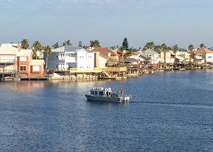
nowCOAST data now available through the Web-based Emergency Operations Center
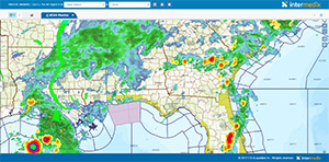
Image of nowCOAST data in WebEOC.
The Web-based Emergency Operations Center's (WebEOC) new mapping add-on now consumes nowCOAST data layers. WebEOC, a product developed by Intermix, Inc., is a web-enabled crisis information management system that allows real-time sharing of information among user. WebEOC is used by federal, state, and local emergency management agencies around the U.S. such as EPA, FEMA, the states of New Hampshire, Kansas, and Florida, Chatham County, SC, and Boston.
John Kelley worked with WebEOC in June to coach them on how to consume the publicly available map services. The nowCOAST team reviewed a draft of WebEOC's quick reference guide to ensure they were properly describing the datasets in nowCOAST and gave proper credit to NOAA. A new version of the WebEOC map add-on will be released by December, which will include legends for the data layers obtained from nowCOAST map services. For further information, contact
John.Kelley@noaa.gov.
U.S. Representative Carter tours NOAA Ship Thomas Jefferson
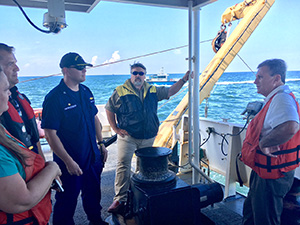
Tracy Dowdy, Kyle Ward, Cmdr. Chris Van Westendorp,
Hunter Hall, and Rep. Carter during the NOAA Ship Thomas
Jefferson tour.
Southeast navigation manager,
Kyle Ward, accompanied Rep. Earl "Buddy" Carter, Hunter Hall (staff), Tracy Dowdy (staff), and Captain Trey Thompson III (Master Pilot, Savannah Pilots Association), for a tour of NOAA Ship Thomas Jefferson. The group boarded Thomas Jefferson while the ship was conducting hydrographic surveys on its Approaches to Savannah project (TJ-17-01). This survey project will provide accurate updated nautical charts when the major deepening project is completed in the 2018. Rep. Carter was interested in a variety of topics including how our survey areas relate to traffic patterns in and out of the port, ship recapitalization and the importance of our mission to maintain the movement of commerce, and the Intracoastal Waterway. Thank you to
Cmdr. Chris Van Westendorp,
Lt. Cmdr. Olivia Hauser, and
Lt. Anthony Klemm for hosting the group, providing an excellent tour, and communicating the importance of the Coast Survey mission and assets. For more information, contact
Kyle.Ward@noaa.gov.
Coast Survey's marine geography interns conclude their summer program
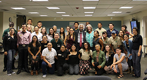
Internships in Marine Geography Program's class of summer
2017 along with thier instructors.
Coast Survey’s pilot year of the Internships in Marine Geography Program concluded on August 10 after a four-day career workshop, sponsored by the National Park Service and in collaboration with our partner the
Greening Youth Foundation in Denver, Colorado. As part of the workshop, the four NOAA interns (Aleah, James, Nia, and Remy) presented their projects, learned about the federal hiring process, and heard from inspiring speakers about the importance of diversity in the science and conservation fields. The four NOAA interns provided support to various projects like retrofitting equipment on the new NRT2 vessel, assessing more than 3,000 source areas of interest, chart adequacy for the North Slope of Alaska, and creating a communication plan for the Hydrographic Health model. A call for summer 2018 project descriptions will come out this fall. If you are interested in hosting a summer intern, please consider scoping out a project that could be completed within 10 weeks. For more information, contact
Amanda.Phelps@noaa.gov.
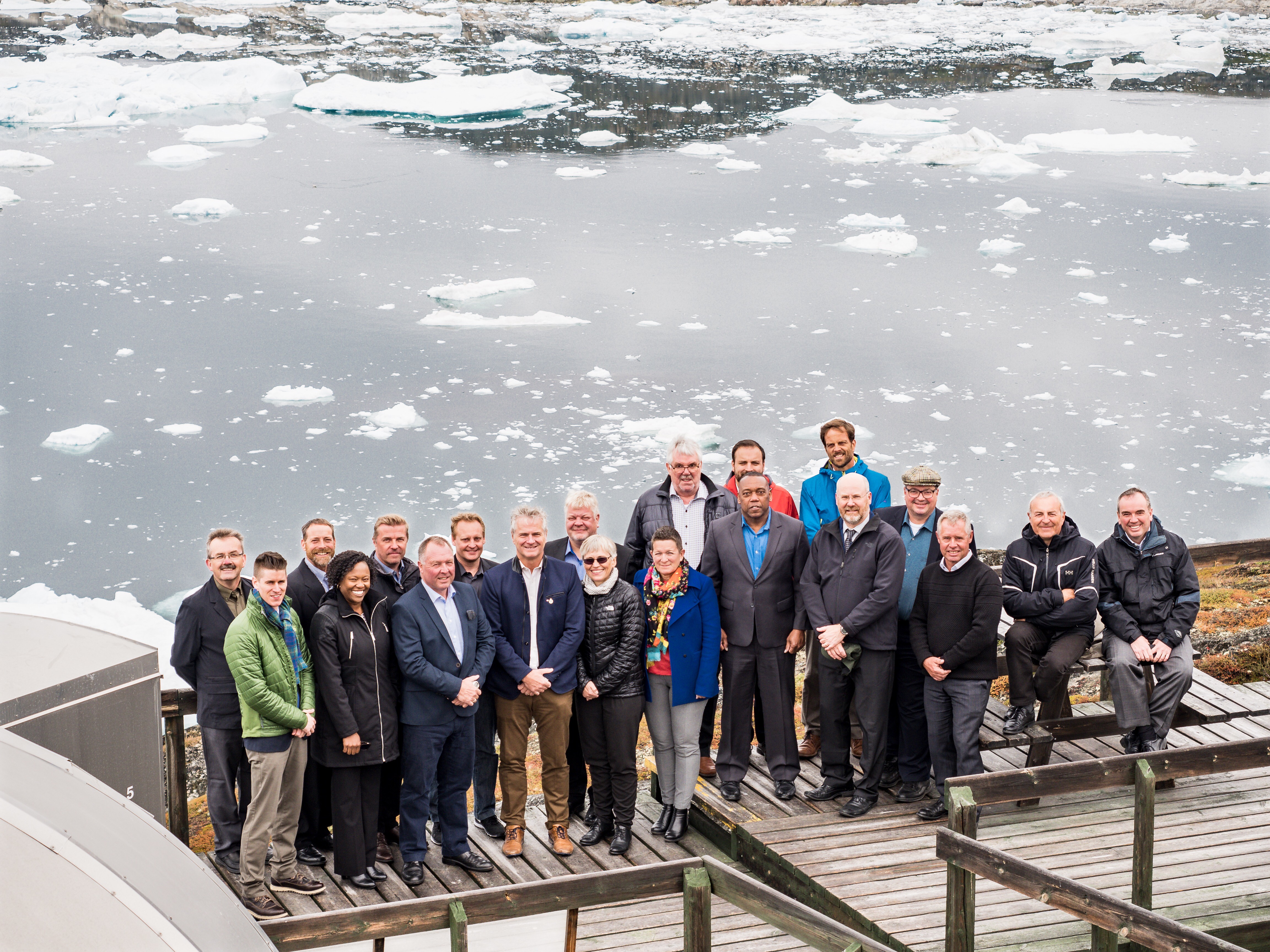
Rear Adm. Smith leads U.S. delegation to the Arctic Regional Hydrographic Commission meeting
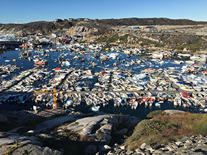
Ilullisat, Greenland, location of the Arctic Regional
Hydrographic Commission meeting.
Rear Adm. Smith led the U.S. delegation to the
Arctic Regional Hydrographic Commission meeting last week in Ilullisat, Greenland. Hydrographic authorities from Canada, Denmark, Finland, Iceland, Norway, Russia and the United States
attended the meeting. The first day brought together stakeholders from local governments, academia, and industry to discuss Arctic community interests and needs related to hydrography and Arctic science. That was followed by a two-day meeting on a series of cooperative interests among the countries ranging from emerging technologies and their applications in the Arctic (autonomous vehicles, for example) to marine spatial data infrastructure, crowd sourcing, and charting. Altogether, the meetings were well attended with nearly 40 participants. Special kudos to the Coast team for their contributions to making this a particularly successful meeting including
Colby Harmon for his engagement in the Charting Working Group and especially for progress resolving the last of the U.S. ENC overlaps in the Arctic;
Sam Greenaway and his team for proposing a reassessment of chart adequacy in the region which was widely endorsed at the meeting;
Lt. Matt Forney for pulling together material on the Bering Strait Port Access Route Study and NOAA (Coast Survey) engagement with local communities in Alaska;
Vanessa Miller for developing the U.S. National Report and interagency coordination;
Jill Stoddard and
Alexanderia Allison for logistal and travel support; and
Jonathan Justi for overall organization. The meeting report, files, and actions are being posted by the Chair (Denmark) to the International Hydrographic Organization
website. For more information, contact
Jonathan.Justi@noaa.gov.
Coast Survey team attends FOSS4G 2017
George Britzolakis,
Leland Snyder,
John Kelly, and
Jason Greenlaw attended the International Conference for Free and Open Source Software for Geospatial (FOSS4G) in Boston from August 14-19. They attended workshops, listened to experts on emerging technologies that have an impact on future geospatial development, and made new connections with participants from around the world. Recorded presentations will be available online in the near future at the
FOSS4G 2017 website. For further information, contact
George.Britzolakis@noaa.gov.
Coast Survey represented at the NOAA Emerging Technologies Workshop
Several individuals from Coast Survey attended the
2nd NOAA Emerging Technology Workshop in College Park, MD, from August 22-23. In order to capture the enormous breadth of NOAA observations, the workshop brought together NOAA researchers, analysts, and practitioners of systems—both traditional and nontraditional; both remote sensing and in situ—from across the following four domains: oceans, atmosphere, terrestrial, and space. The workshop provided an opportunity to showcase sensors and platforms that could replace or improve current capabilities, lower costs, and fill current gaps in the next three to five years. During the workshop Capt. E.J. Vandenameele, chief of the Coast Survey Develop Lab presented “Leveraging Autonomy – NOAA Office of Coast Survey’s Autonomous Systems Strategy.” For more information, contact
Edward.J.Vanenameele@noaa.gov.
Disaster recovery: Mission accomplished
Coast Survey achieved an important milestone this summer—the completion of testing and deployment of a robust disaster recovery (DR) solution for Silver Spring's IT infrastructure. The products that serve the public, as well as resources our employees use to complete their mission, are covered. In case of an adverse event in Silver Spring, these products and services will be able to run from our Seattle, WA, server room (at PHB), or in the case of some web-based services, from the NOS-supported Microsoft Azure Cloud. In total, there are approximately 90 servers that are covered in this solution, and about 120-125 Coast Survey services are installed and DR-ready across this infrastructure. There are many within Coast Survey who made this achievement possible, in particular several members of the Coast Survey IT team including
Anthony Johnson (lead),
Tim MacLaughlin,
Jack Huang,
Tom Rhodes,
David Barglow,
Thanh Pham,
Dera Byers,
Mary Louise Kurchock,
Jose Rivera,
Stephen Gallaher, and the entire
OCS Help Desk. This also could not be possible without the expertise and testing support of many folks from MCD, CSDL, NSD, and HSD. We look forward to exploring disaster recovery solutions for both AHB and PHB and further cloud options as new project challenges. For more information, contact
Neeraj.Saraf@noaa.gov.

Coast Survey responds to Hurricane Harvey
NRT2 surveying in the Corpus Christi area in response to
Hurricane Harvey.
Hurricane Harvey is the first major hurricane of the 2017 Atlantic hurricane season. Harvey strengthened to a Category 4 reaching landfall along the Texas coast on Friday, August 25, at peak intensity. By the next day, the storm weakened to a tropical storm bringing torrential rainfall to the region. Catastrophic inland flooding is ongoing in the Greater Houston and surrounding areas.
Before the storm reached landfall, Coast Survey headquarters and field units were planning and positioning assets in strategic locations in proximity to the Texas coastline. The western Gulf Coast navigation manager, Alan Bunn, is currently at the Houston Galveston ICC at Ellington Field supporting response coordination efforts. The eastern Gulf Coast navigation manager, Tim Osborn, traveled from Lafayette, LA, and is now at U.S. Coast Guard Sector Corpus Christi ICC supporting response coordination efforts.
Navigation response team (NRT) 2, (homeported in Fernandina Beach, FL, and deployed with James Kirkpatrick, Lucas Blass, and Alex Ligon - augmenting from NRT1) traveled to College Station, TX, to position themselves for response. Our survey capabilities were first requested to assist in the vicinity of Corpus Christi and as of Wednesday morning, August 30, NRT2 began surveying in the Corpus Christi area.
NRT 4 (homeported in Galveston, TX, with Dan Jacobs, Erin Diurba, and Charles "Wess" Rowland) is in a holding pattern until waters recede in the Houston area. The survey boat is staged and prepped for towing but due to flooding, the team cannot reach it. Coast Survey is mobilizing personnel from the Navigation Response Branch (Michael Annis), Bay Hydro II (Lt. j.g Patrick Debroisse), and NRT 5 (Eli Smith) to Stennis, MS, to support the mobile integrated survey team (MIST) and augment staffing for NRT4. NRT 1 (homeported at Stennis, MS, with Lt. Cmdr. Jonathan French and Joshua Bergeron) are standing by, providing logistics coordination and MIST support. This positioning of team members and assets will help accommodate the Coast Guard and U.S. Army Corps of Engineers requests for additional assets to support offshore survey needs for port response along the Texas coastline.
Thank you to all Coast Survey staff that are involved in planning and responding. For information pertaining to the response effort, contact Capt. James.Crocker@noaa.
NOAA ship, NRT, and contractor operations
Weekly Hydro Ship Activity Report: Week of August 20

Staff Updates
Cmdr. Lomnicky is joining the Navigation Services Division as the new chief of the Navigation Response Branch, where he will lead NOAA’s mobile hydrographic survey teams. Cmdr. Lomnicky comes to us after serving as NOAA Ship Rainier’s commanding officer.
Lt. Cmdr. Jonathan French is now the officer in charge of NRT 1. Welcome Lt. Cmdr. French!
Joshua Bergeron is joining NRT 1 as a new team member. Joshua recently finished the hydrography program at the University of Southern Mississippi. Welcome Joshua!


