CSDL evaluates radio communications system for autonomous and remotely operated platforms
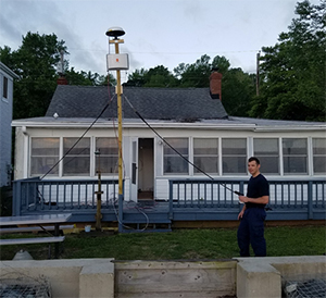
Shoreside antenna mast at beach house station.
Coast Survey Develop Lab’s Hydrographic Systems and Technology Branch is investigating new radio communication systems to enable high bandwidth connections from ships to multiple autonomous and remotely-operated platforms. These systems will allow for remote troubleshooting, remote acquisition, real-time streaming of data, and possibly command and control of the autonomous platforms themselves. The Kongsberg MBR and the Silvus StreamCaster are examples of newly developed radio communications systems. The lab also has an existing system, the Microhard IPn920, that is low in bandwidth, but is inexpensive. During the first week of May,
Eric Younkin and
LT Charles Wisotzkey traveled to Solomons, Maryland, the homeport of the
Bay Hydro II, and evaluated the range and throughput of each system. They found that the Kongsberg radio had an impressive range (out to 40 miles!) and the Silvus boasted a remarkable bandwidth, capable of supporting nearly all of Coast Survey's needs in this area. For more information on this project contact
Eric.G.Younkin@noaa.gov.
New commemorative chart marks the Battle of Midway’s 75th anniversary
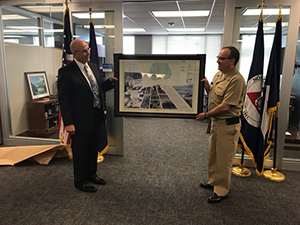
Presentation of the 75th anniversary Battle of Midway
commemorative chart by Joe Linza, Lynker Technologies, to
RDML Smith.
Coast Survey, Office of National Marine Sanctuaries, and Lynker Technologies collaborated to create a
commemorative nautical chart for the Battle of Midway’s 75th anniversary. This nautical chart was first published in 1943, and the commemorative chart includes the original depth soundings surrounding the islands overlaid with historical photos from the battle. The Battle of Midway was fought from June 3–7, 1942, at and around the island of Midway in the central Pacific Ocean. Today, it is considered to be the decisive battle of the war in the Pacific. Midway Atoll lies within
Papahānaumokuākea Marine National Monument, a marine protected area encompassing all of the Northwestern Hawaiian Islands. Thank you to
Richard Powell (NSD) for designing the chart, to
Kelly Keogh (Office of National Marine Sanctuaries) and
John Cloud (NOAA Library) for writing and reviewing the content, and to
Steve Soherr for facilitating the process. For more information on this project contact
Steve.Soherr@noaa.gov.
Coast Survey meets with United Kingdom Hydrographic Office
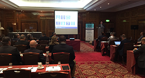
RDML Smith presents at the Unmanned Maritime
Systems Technology Conference.
RDML Smith,
Rachel Medley, acting deputy hydrographer, and
John Nyberg, chief of the Marine Charts Division, met with the United Kingdom Hydrographic Office (UKHO) in London. UKHO and Coast Survey are global leaders in charting standards and practices. Fostering this relationship is vital to continued international cooperation and global understanding of both agencies’ divergent markets and practices. While in London, RDML Smith also presented at the Unmanned Maritime Systems Technology Conference where he introduced Coast Survey’s autonomous systems strategy. This strategy focuses on leveraging autonomy for more efficient and effective acquisition of environmental information. Conference participants included the Royal Navy UK, NATO Allied Maritime Command, and U.S. Office of Naval Research Global. For more information on this project contact
Rachel.Medley@noaa.gov.
Port of Tampa hosts hurricane exercise
On June 5, the Port of Tampa held a 96-hour exercise simulating a Category 2 hurricane with nine foot storm surge striking the Tampa Bay area. The purpose of the exercise was to practice coordination among Belfour Property Restoration, the port’s Red Alert Service Provider, Port Tampa Bay personnel, Port Heavy Weather Advisory Group, U.S. Coast Guard, Tampa Pilots, Hillsborough County Sheriff’s Office and Fire Rescue, Customs and Border Protection, and port tenants. During the exercise, participants discussed knowledge of their mission and capabilities, both in advance of the storm’s landfall and in the aftermath. A big thank you to Eastern Gulf Coast navigation manager,
Tim Osborn, who participated in the event on behalf of Coast Survey, and congratulations to all who took part in this crucial exercise. For more information on this exercise contact
Tim.Osborn@noaa.gov.
Deputy hydrographer represents Coast Survey at North Atlantic Ports Association
Rachel Medley, acting deputy hydrographer, attended the annual
North Atlantic Ports Association (NAPA) summer meeting in Wilmington, Delaware. NAPA members include representatives from port authorities of varying capacities from Virginia to Maine. Leadership from the American Association of Port Authorities also attended the meetings and spoke candidly about federal budget impacts to maritime infrastructure and potential affects to U.S. ports. While attending the conference, Rachel interacted with port authority representatives who expressed interest in learning more about bathymetric surveying capacity in their channels and the prospect of increased port optimization without expansion or dredging. Rachel also met with staff from Senator Coons' (D-DE) office to discuss survey requirements and potential new port terminals opening up on the Delaware River. For more information on this event contact
Rachel.Medley@noaa.gov.

NOAA Ships, NRTs, and Contractors:
NOAA SHIP FERDINAND R. HASSLER
NOAA Ship Ferdinand R. Hassler is alongside U.S. Coast Guard Curtis Bay Shipyard for a scheduled repair period. Tentative completion is late July.
NOAA SHIP RAINIER
NOAA Ship Rainier has been busy these past two weeks. The crew participated in helicopter evacuation drills with the U.S. Coast Guard, held an open house over Memorial Day Weekend for the Crab Fest in Kodiak, Alaska, and continued survey operations around Chiniak Bay, Kodiak.
Staff Updates
Long time NSD Navigation Response Branch member,
Mark McMann retired on April 1 after more than 38 years of service, all with our navigation response teams. Mark was part of countless surveys and hurricane responses including Katrina and, just last year, Matthew. As NRT1's lead, he kept his team safe and mission ready for a number of years, ensuring we had a reliable emergency asset in the Gulf region. We wish Mark all the best in his retirement. He will be missed.
Awards
Recently, NSD’s Navigation Response Branch, NOAA Ship Ferdinand R. Hassler Permanent Crew, and individuals from NSD’s Customer Affairs Branch, HSD, and CO-OPS were awarded the Coast Guard Meritorious Team Commendation for their response to Hurricane Matthew from October 7 to October 18, 2016, by the commandant of the U.S. Coast Guard, Admiral Paul F. Zunkunft. The award was presented on behalf of the commandant by Captain G.L. Tomasulo, commander of the Coast Guard Sector of Charleston, South Carolina.
Bike to Work

Bike to Work Day participants at PHB.
May is Bike Everywhere Month and the Hydrographic Surveys Division's Atlantic and Pacific hydrographic branches joined forces this year to create a Bike Everywhere Team. The team biked a total of 1,853 miles during the month of May which would be the equivalent to biking from Seattle to Kansas City, Missouri. Keep on rolling you biking hydrographers!