By HAST Bailey Schrader, Operations Officer Lt. Shelley Devereaux and HST Adriana Varchetta
After enjoying the California sunshine in San Francisco Bay, NOAA Ship Fairweather began its transit down the coast towards Santa Barbara, California. The ship would not anchor for the next sixteen days, leaving all crew on 24-hour rotations. Thankfully, the already attenuated crew was visited by augmenting scientists and hydrographers – Physical Scientist Devereaux from the Pacific Hydrographic Branch, HHST Arboleda from NOAA Ship Thomas Jefferson, and HAST Schrader from NOAA Ship Rainier. Together, they traveled south to complete one of the last projects of the season, the area in and around Channel Islands National Marine Sanctuary.
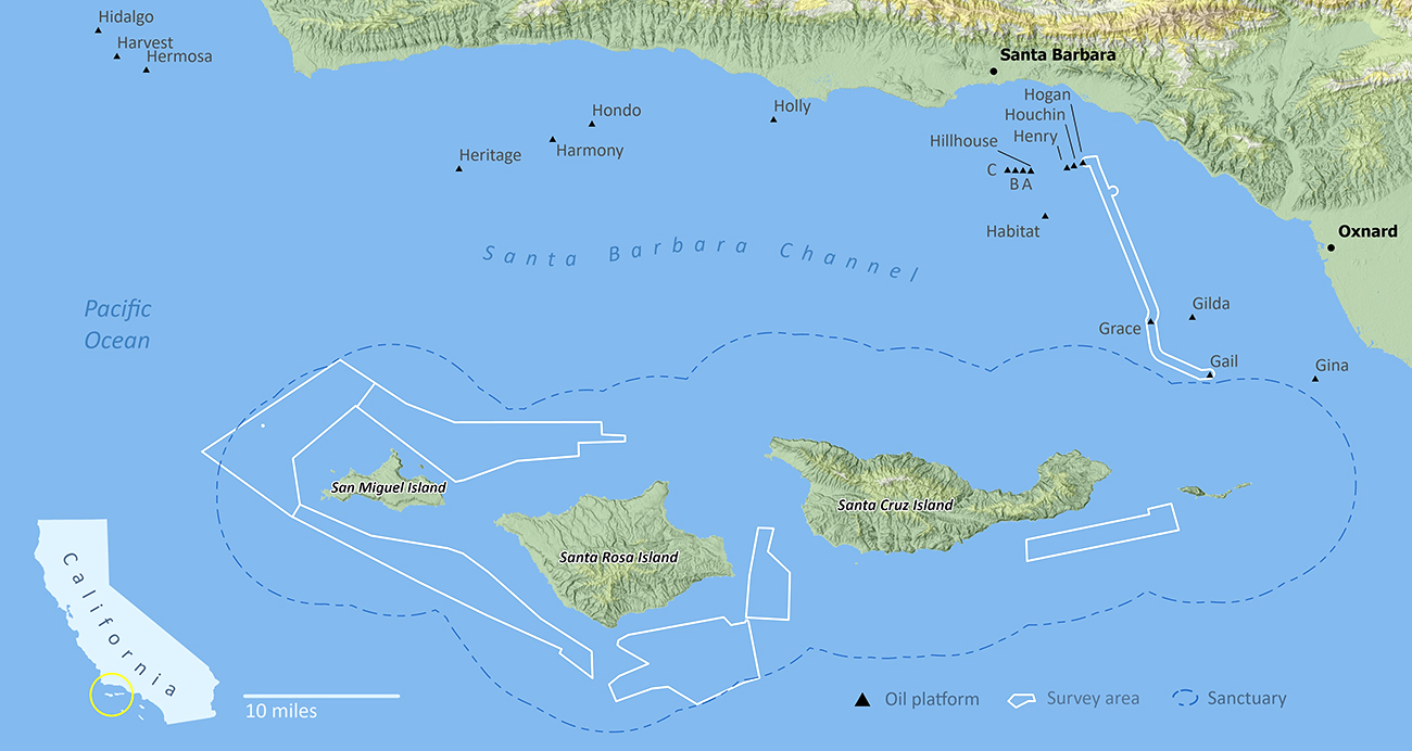
The sanctuary protects 1,470 square miles of ocean water, and is inhabited by an abundance of biodiversity including protected and endangered species, as well as sensitive and threatened habitats. Indeed, the abundance of sea life and aquatic habitats drives a thriving industry of recreational and commercial fishing which brings varied vessel traffic through the area’s waters. Some of this traffic, especially industrial shipping, poses a threat to the area’s delicate ecosystem. In contrast to the region’s rich ecology, there also exists a series of operational and defunct offshore oil and gas platforms that lie just outside of the sanctuary’s boundary. Accordingly, our assignment tasked us to survey 151 square miles in and around the sanctuary’s ocean floor. Unlike our previous projects, there was a specific emphasis on the collection of backscatter and water column data to elucidate habitat conditions and the state of benthic oil platform pilings and pipelines. This data will be used to update nautical charts, for sanctuary conservation and benthic sciences. The Bureau of Ocean Energy Management intends to also use the data to evaluate the current condition of existing offshore platforms and pipelines, and prepare for next steps to support the strategic decommissioning of these assets.
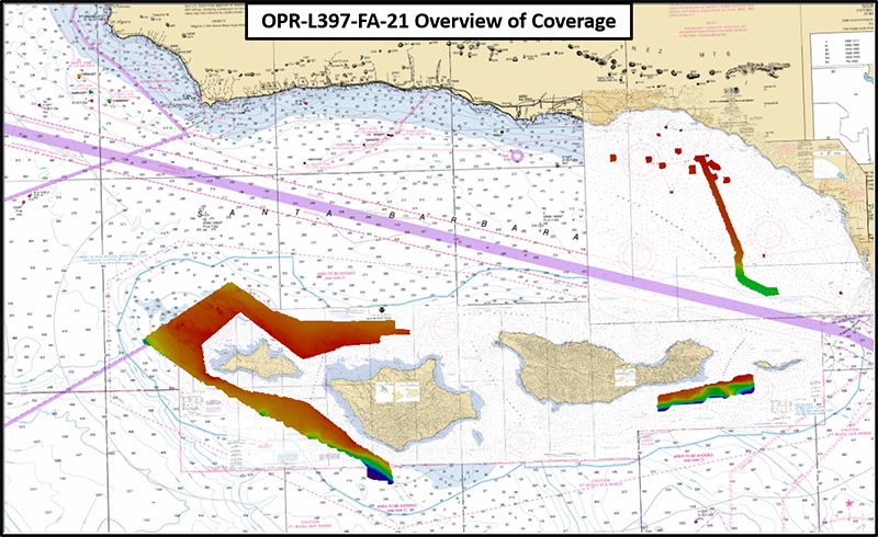
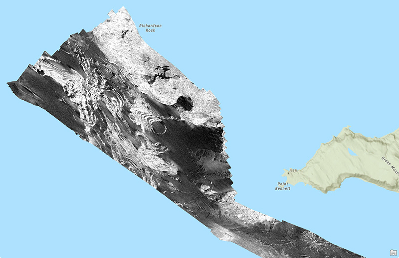
The first portion of the project was composed of shallow waters inside of the sanctuary, just offshore of San Miguel, Santa Rosa, and Santa Cruz islands. The work this field season marks one of the final projects in a multi-year effort since 2017 to survey the entirety of Channel Islands National Marine Sanctuary, primarily conducted by NOAA Ships Rainier and Fairweather. These waters see a number of recreational vessels and commercial fishing, with a steady influx of kayakers, surfers, whale watchers, and researchers all appreciating the abundance of unique wildlife endemic to the islands. Through better understanding of the depths and characteristics of the ocean floor surrounding the islands, scientists can better establish the marine ecosystem that allows these creatures to thrive.
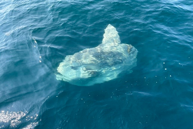
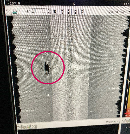
During our two weeks on project, we had the good fortune of seeing some of this marine life for ourselves. The common mola, or ocean sunfish, are known to bask in a horizontal position at the surface of the water, and would pay our survey crews the occasional visit. As one of the heaviest bony fish in the world, weighing up to an incredible 4,400 pounds, they were as easy to spot from the bridge wings of the ship as from the coxswain chair of the survey launches. Though the regular sight of bottlenose dolphins playing in our bow wake and spouts from surfacing whales from a short distance brought delight to survey crews and bridge teams, their presence occasionally interfered with clean data acquisition. We even spied a whale swimming with a calf in our backscatter data, confirmed by an eager radio from personnel on the fantail.
This second portion of the project – the pipeline and platform investigation – provided an interesting juxtaposition against the protected sanctuary. The investigation necessitated traveling north, inshore of Santa Barbara Channel and northwest towards Point Conception. There, dotted across the coastline, are 32 oil platforms in varying states of operation. Although a moratorium on new offshore oil and gas leasing has been in place since 1988, there are still at least nine active rigs which pump thousands of gallons of fossil fuels to shore each day. The presence of these oil rigs appear anachronistic for their settings as California spearheads the nation’s movement away from fossil fuels. The structures themselves are among the world’s most productive marine hotspots. Many fish congregate around the platform pillars while hundreds of thousands of crustaceans attach to them in mats. Nonetheless, the project called for Fairweather to survey these platforms and two underwater oil pipelines.
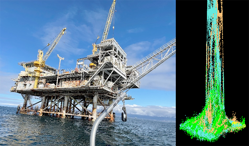
The requirements for both portions of the project emphasized the production of quality backscatter data. Backscatter is acoustic energy that is reflected from the seafloor back towards the direction from which it originated. Acoustic energy behaves differently depending on the substrate composition. For example, harder bottoms like bedrock reflect more acoustic energy than softer bottoms like mud. A concerted effort was made to constrain as many variables as possible and acquire high-quality backscatter data. Brighter areas indicate a rocky bottom type, whereas duller gray indicates a muddy or softer bottom type. The seafloor west of Point Bennett was especially interesting, revealing fold after fold of unique rock formations in the sea floor.
Since any significant course change can easily smear backscatter data, the navigation of vessels along straight lines was highly stressed and particularly challenging for several reasons. Contours around islands and coastlines are curved, and the dropping seafloor shelves create ever-changing coverage swaths to contend with. Additionally, shifting winds and large swells often push the ship off course, making it difficult to hold both a consistent heading and allow for a comfortable ride for the crew.

Though the waters of southern California brought new mission focuses and data acquisition needs, Fairweather’s crew once again rose to the challenge. Despite facing a gale and thunderstorms, we were able to finish five sheets in a comparatively short two week span.
The expedition conducted by NOAA Ship Fairweather in the Channel Islands National Marine Sanctuary highlights the importance of comprehensive surveys and data collection to understand and protect delicate marine ecosystems. The sanctuary, spanning 1,470 square miles, is home to diverse marine life, including protected species and threatened habitats. However, the area faces risks from industrial shipping and offshore oil and gas platforms situated just outside the sanctuary’s boundaries.
The survey focused on collecting backscatter and water column data to assess habitat conditions and the state of benthic oil platform pilings and pipelines. This information will contribute to updating nautical charts, supporting sanctuary conservation efforts, and advancing benthic sciences. Furthermore, the data will aid the Bureau of Ocean Energy Management in evaluating the condition of existing offshore platforms and pipelines, facilitating future decommissioning plans.
The project encompassed shallow waters within the sanctuary and the investigation of oil platforms and pipelines near the Santa Barbara Channel. The surveys provided valuable insights into the depths and characteristics of the ocean floor, enabling scientists to better understand the marine ecosystem that sustains the unique wildlife endemic to the Channel Islands.
During the expedition, the crew had the opportunity to witness the abundance of marine life in the area. Sightings of the common mola, bottlenose dolphins, and whales added excitement to the survey operations, although occasionally posing challenges to data acquisition. The juxtaposition of the protected sanctuary and the presence of operational oil platforms highlighted the complexities and contradictions in balancing environmental conservation and energy production.
The emphasis on producing high-quality backscatter data demonstrated the importance of understanding substrate composition and its acoustic properties. The project navigated various challenges, including curved contours around islands, shifting winds, and seafloor shelves, to ensure accurate data collection.
Overall, the expedition showcased the dedication of NOAA and its partners in conducting thorough surveys and gathering valuable data to support the management and conservation of the Channel Islands National Marine Sanctuary. By understanding the marine ecosystem and the impact of human activities, stakeholders can make informed decisions to protect this ecologically significant area for future generations.
https://piping-clean.com/product/pig-signaler/