by Melissa Volkert, Coast Survey communications associate
NOAA’s Office of Coast Survey has added a wide range of publications to our Historical Map and Chart Collection. The collection of publications consists of annual reports, catalogs, United States Coast Pilot, Notes on the Coast, and special reports.

- Annual Reports are yearly publications, from 1837 to 1965, that detail the many scientific and technological activities of Coast Survey.
- Aeronautical charts, U.S. nautical charts, charts of the Philippines, and the old U.S. Lake Survey charts are detailed in Catalogs.
- The Coast Pilot collection carries two centuries of volumes, from a 1796 version of the American Coast Pilot, through the 1800s and 1900s, until the 2012 versions of the U.S. Coast Pilot.
- Written in 1861 by the Coast Survey while Superintendent Alexander Bache served on the Blockade Strategy Board, Notes on the Coast were instrumental in the Union naval strategy during the Civil War.
- When geodetic, hydrographic, geophysical, and oceanographic methods were hard to find in annual reports, over 400 Special Reports, issued between 1898 and 1956, made the information easier to disseminate.
These publications provide context to the tens of thousands of maps and charts in the collection. Use the “Search Images” and “Search Publications” pages to explore the historic documents.
As an example, consider the great naturalist John Muir, whose 179th birthday is this month. He was a guide and artist on the Survey of the 39th Parallel across the Great Basin of Nevada and Utah from 1874 to 1877.
- Select “Search Publications” on the Historical Map and Chart Collection. Enter:
- 1874 as Year Min
- 1877 as Year Max
- John Muir in Keywords
One result emerges: the 1875 Annual Report. This report notes, on page 62, that John Muir recorded the geological and botanical characteristics of Mount Shasta in Northern California. A “related maps” option, showing maps and other images mentioned in the publication, will be to the left of this result. In this case, the related maps include a map titled “Sketch Showing the Progress of the Survey on the Atlantic Gulf of Mexico and Pacific Coast of the United States with Sub Sketch Showing the Progress on the Pacific Coast.” This particular map was continually updated as new areas were surveyed and discovered. 1875 was the first year that Mt. Shasta was recorded on it.
You can also use the information from an image to locate a publication. This month marks the 99th anniversary of the 1906 San Francisco earthquake. Using Search Images on the Historical Map and Chart Collection:
- Select the San Francisco area on the map or type San Francisco, CA (Populated Place) into Geographic Name.
- Organize the results by Year Published.
- Locate a map of California from 1907, titled “California Counties, Creeks, Islands, Lakes, Mountains and Peaks, Rivers and Towns.”
Since this map is from 1907 and there are no images from 1906, assume findings after the earthquakes were not published until 1907.
- Search publications for the Annual Report of 1907.
- When the report is opened, use the “Ctrl+F” search function (press Ctrl & F together)
- Type California in the search bar that appears at the top right.
- California will be highlighted every time it is stated in the document.
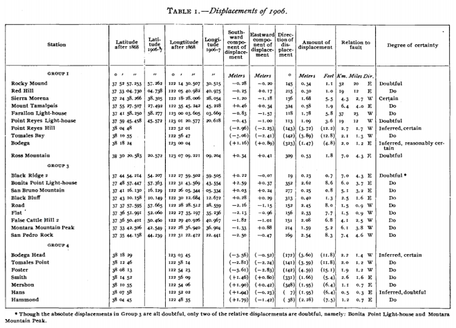
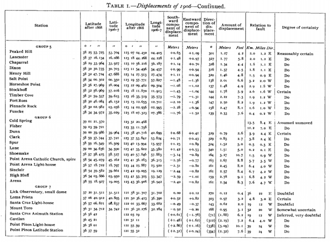
On page 67, there is a section entitled “Earth Movements in the California Earthquake of 1906.” This section ‒ that highlights new vs. old triangulation, and the permanent displacements of the areas affected ‒ states, “…the effects of the earthquake of April 18, 1906, indicated that there had been relative displacements of the earth’s surface from 2 meters (7 feet) to 6 meters (20 feet) at various points near the great fault accompanying the earthquake.”


The tables indicate the permanent displacements of various points caused by the earthquake of 1906. These permanent displacements were determined by comparing the positions of identical points upon the earth’s surface as determined by triangulation before and after the earthquakes in question. (Discover how the U.S. Coast and Geodetic Survey aided the recovery of the San Francisco earthquakes of 1906 by reading the 1907 Annual Report.)
The Historical Map and Chart Collection documents Coast Survey’s discoveries throughout history. Make your own discoveries in the collection, and let us know if you have any comments, questions, or concerns.


Will the USC&GS Field Engineer Bulletins be added to this collection? Some of the information in these is very valuable as well.
Thanks for the reminder, Guy Noll. The NOAA Library scanned the Bulletins earlier, and so we have been able to add them to the collection. Search Publication Type: “Book – Other”
Reblogged this on Boating Safety Tips, Tricks & Thoughts from Captnmike and commented:
More history from the massive archives of NOAA including early Coast Pilots and other historic documents including earth movements of the California Earthquake of 1906
I think you might have a typo in the 1876 start date – that would only make 136 years of the Coast Pilot – thanks for more historic documents – I have passed the link on to teachers and history buffs I know
The Coast Pilot collection carries two centuries of volumes, from the 1876 version of the American Coast Pilot, through the 1800s and 1900s, until the 2012 versions of the U.S. Coast Pilot.
Thanks, yes that was a typo. The earliest Coast Pilot in our collection is from 1796.