The U.S. Board on Geographic Names recently named four previously unknown basins in the United States Exclusive Economic Zone (EEZ) in the Gulf of Mexico, honoring retired NOAA officers who mapped the area in the late 1980s and early 1990s. The names — Armstrong Basin, Floyd Basin, Matsushige Basin and Theberge Basin — were proposed by Texas A&M University, based on their new compilation of bathymetry drawn largely from the NOAA multibeam mapping project conducted by now-decommissioned NOAA ships Whiting and Mt. Mitchell.
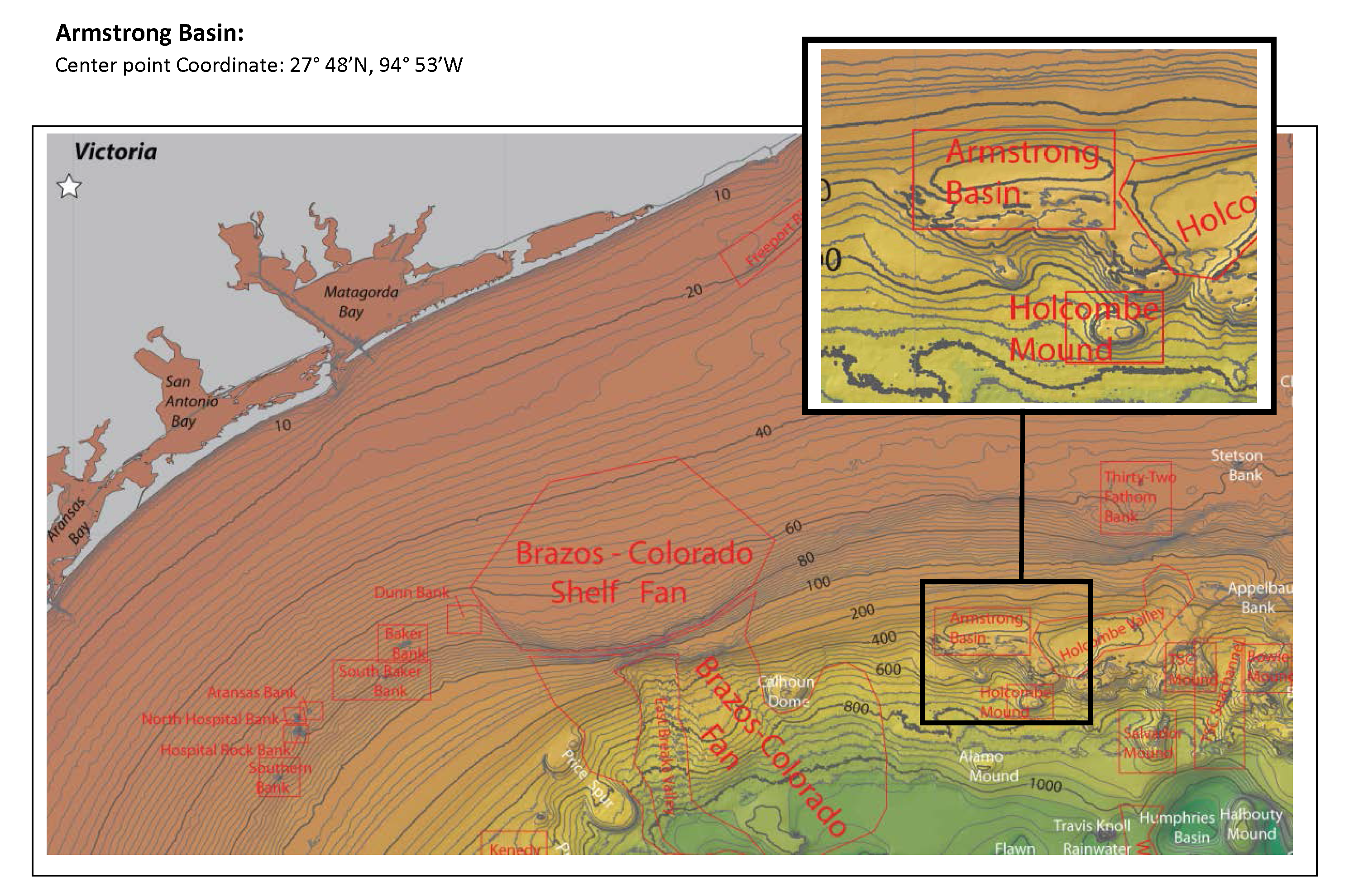
Retired NOAA Capt. Richard P. Floyd was the commanding officer of NOAA Ship Whiting from February 1990 to March 1992; he was followed by retired Capt. Andrew A. Armstrong III, who was CO from February 1992 to January 1994. Retired NOAA Capt. Roy K. Matsushige was commanding officer of NOAA Ship Mt. Mitchell from December 1988 to January 1991, followed by retired Capt. Albert E. Theberge, who served as CO from January to November 1991. The officers led the bathymetric mapping operations under the direction of NOAA’s Office of Charting and Geodetic Services, a predecessor of today’s Office of Coast Survey.
Cartographers rely on the Board of Geographic Names, for good reason!
Since 1890, federal cartographers have relied on the decisions of the U.S. Board on Geographic Names — the 125-year multi-agency federal program to standardize names of geographic features — that operates under the umbrella of the Department of the Interior.
“The Board on Geographic names has its intellectual roots in the earliest map-making efforts,” explains Theberge. To illustrate the need for standardization in the U.S., Theberge points to a November 7, 1805, report by the famed explorer William Clark.
“Ocian in view! O! the joy… Great joy in camp we are in view of the Ocian, this great Pacific Octean which we been So long anxious to See.”
As Theberge points out: “In one sentence, Clark gives the reasons for the Board.”
EEZ mapping project achieved policy and technical objectives for U.S.
The four NOAA commanding officers led surveys for the EEZ mapping project, which was active between 1984 and 1991. The project originated from President Ronald Reagan’s 1983 proclamation establishing a U.S. Exclusive Economic Zone, which created a 200-mile-wide nautical “belt” around the U.S. and territories, adding over 3,000,000 square nautical miles to the nation’s jurisdiction.
In response to the EEZ proclamation, both NOAA and the United States Geological Survey embarked on mapping programs. The USGS used a deep-water, very wide swath, side scan sonar system called GLORIA, which gave a qualitative picture of the seafloor somewhat akin to aerial photography; and NOAA used both medium depth multibeam sounding systems (150 meters to 1000 meters) and deep water systems (1000 meters depth to full oceanic depth), which gave quantitative (depth) values. As opposed to widely-spaced single beam trackline in deep water areas, NOAA’s program attained 100% bottom coverage with the then-new (to the civil community) multibeam systems.
The Gulf of Mexico was one region of the mapping program, as maps were produced for waters of the East Coast, Gulf of Mexico, West Coast, Alaska, and Hawaii. In a paper presented at the 1988 Exclusive Economic Zone Symposium, the goals of mapping in the Gulf of Mexico (actually applicable to all EEZ regions) were espoused:
- Build the foundation of a marine environmental geographic information system for solving global and regional change problems.
- Improve targeting of scientific and engineering efforts involving higher-cost, manned, submersible investigations and remotely-operated vehicle operations.
- Better manage the living and mineral resources of the EEZ.
- Better model the physical oceanography of the Gulf of Mexico, including factors affecting water mass movements, acoustic propagation paths, and sediment transport regimes.
- Model geological and geophysical hazards affecting coastal regions and offshore construction.
- Discover and/or define unique or previously unknown marine environments for designation as marine sanctuaries or protected areas.
- Improve and enhance nautical charts and bathymetric maps.
This early multibeam mapping effort helped develop many concepts that Coast Survey later built on in shallow water multibeam charting, such as methods for correcting and calibrating beam pointing errors, use of GPS, ray-bending algorithms to account for refraction of beams, etc. Philosophically, the project also helped pave the way for the era of digital paperless survey data acquisition and processing, as EEZ survey operations significantly reduced the vast amounts of paper fathograms, printouts, and other products that accompanied classical hydrographic survey operations.
In 1992, a report by the Marine Board of the National Research Council addressed the needs of mapping the EEZ. It noted:
“EEZ mapping and survey activities of the USGS and NOAA have been impressive, especially given the limits on funding, assets, and human resources. …The current activities depend on individual efforts and assets that are, in many instances, borrowed or diverted from other projects.”
By the time the report was written, circumstances — including the grounding of the Queen Elizabeth II in Martha’s Vineyard Sound — dictated that NOAA devote more resources to inshore charting. The EEZ project was terminated but it left a legacy of new and improved methods, as well as a gentle nudge towards a paradigm shift from primarily paper data acquisition to digital data acquisition.
We still use the digital data gathered by the EEZ mapping project. During the monitoring of the Deepwater Horizon oil spill, NOAA used the data as its underlying bathymetric dataset. The spill was near Whiting Dome and Mitchell Dome, which were named respectively for their discovery by the NOAA ships Whiting and Mt. Mitchell during the EEZ project.
New project picks up where the EEZ project left off
Today, a new national deep-water bathymetric mapping project is underway, picking up where the EEZ project left off. The Office of Coast Survey’s Joint Hydrographic Center at the University of New Hampshire, along with NOAA’s Office of Ocean Exploration, is leading the bathymetric mapping work of the interagency U.S. Extended Continental Shelf (ECS) Project. Using today’s modern high-resolution descendants of the multibeam systems aboard Whiting and Mt. Mitchell, the ECS Project the ECS Project is mapping the continental slope in several regions, including the Gulf of Mexico, to establish the outer limits of the U.S. continental shelf in areas beyond the 200 nautical mile EEZ. Andy Armstrong, of recently named Armstrong Basin fame, continues to use his bathymetric mapping expertise, now conducting mapping operations for the ECS Project.
MT MITCHELL did FIRST Gulf EEZ survey in SPRING 1988!!!