Just over a year ago, Coast Survey began testing the use of small unmanned surface vehicles (USV) to survey the shoalest depths, areas along the shore where NOAA ships and their launches are unable to reach. These USVs proved beneficial not only for mapping shallow, murky waters, but also for improving the efficiency of our hydrographic operations. So what is the next step in evaluating USV technology? Testing larger, longer-lasting USVs and taking them beyond shallow waters.
This September, Coast Survey is partnering with the National Centers for Coastal Ocean Science (NCCOS), the Office of Marine and Aviation Operations (OMAO), NOAA Ship Nancy Foster, and ASV Global, an unmanned vehicle manufacturer, to conduct an operational evaluation of a USV, called the C-Worker 5, during a bathymetric and marine habitat survey offshore of the Carolinas.
A USV is an unmanned small boat that can be remotely operated and monitored from a control station aboard the host ship, and can also be programmed to drive pre-planned survey lines while operators monitor vehicle and data collection systems.
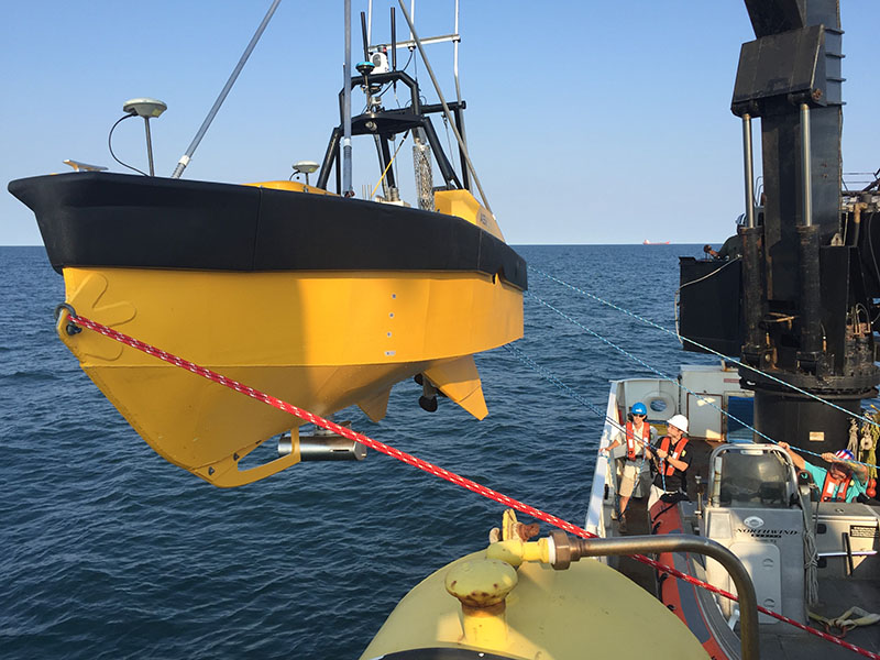
The C-Worker 5 is 5.5 meters and powered by a 57 horsepower diesel engine and can operate for up to five days before requiring recovery and refueling. It is equipped with a Reson 7125 multibeam bathymetric sonar system, similar to systems carried by Nancy Foster, and each can survey a swath of ocean that is about four times as wide as the water depth.
[wpvideo f40lDuA7]
The C-Worker 5 USV is being operated remotely by ASV Global personnel aboard Nancy Foster during testing prior to departing for offshore survey operations.
[wpvideo CGO2ZzrF]
Video and navigation data from the C-Worker 5 is streamed to the ship by telemetry where shipboard technicians keep the vessel safe while monitoring its performance and data quality.
During the cruise, Coast Survey personnel, with support from ASV Global, are evaluating the operational capabilities of C-Worker 5 as it conducts hydrographic survey operations in coordination with Nancy Foster. Coast Survey will use the experience to create a transition path for using USVs in support of routine hydrographic surveys. OMAO will evaluate the shipboard requirements for hosting and operating unmanned systems. The data collected will support NCCOS’s mission to conduct ecological characterizations of hard bottom and rocky reef essential fish habitats in the southeast U.S. Atlantic waters to guide ecosystem management and ocean planning.


News and Updates