March 10, 2021
Hello Coast Survey,
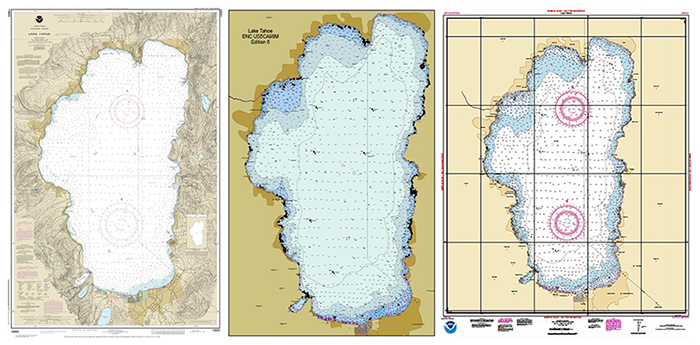
I am happy to have the opportunity to open the Coast Survey bi-weekly newsletter this week to talk to you about raster chart sunsetting and the NOAA Custom Chart application. As many of you likely saw, last week Coast Survey announced the cancellation of the first chart of the raster sunset process, chart 18665 of Lake Tahoe. This initial chart cancellation was intended to test the various systems and processes involved in announcing and cancelling a chart, for example, the Coast Guard’s Local Notice to Mariners system. In the coming months, we will continue the cancellation of additional charts, with all traditional paper and raster charts to be discontinued by January 2025. For more information on raster chart sunsetting please visit this website
This of course is part of Coast Survey’s initiative to focus on the NOAA ENC® as the primary product for navigation, and there are several efforts underway to improve our electronic charts, such as the ENC re-scheming project. That said, we also recognize that there will always be a desire for a paper product, whether to have on the chart table of your vessel for general reference, or simply to view in a format larger than what can be displayed on a monitor. To that end, the Marine Chart Division is developing the NOAA Custom Chart (NCC) application, which can create a customized chart from our ENC data. The NCC allows a user to define the scale, paper size, and limits of the chart they desire, and download a printable PDF of the chart created. In the future, users may be able to print a custom chart using a NOAA print-on-demand vendor. The current version is still a prototype under testing and development, but we expect to release version 1.0 of the application at the end of this month. Many improvements have been made in recent months, including changes to chart symbols that give them more of the look and feel of a NOAA chart. I encourage everyone to try out the NOAA Custom Chart and submit feedback which will help us make it a better product.
Thanks OCS!
CAPT E.J. Van Den AmeeleChief, Marine Chart Division

In light of CAPT Brennan's selection for director of Coast Survey, the following management structure is in place. Once CDR Briana Hillstrom reports as chief of the Hydrographic Surveys Division (HSD), scheduled for fall 2021, most personnel will go back to their permanent roles. CDR Olivia Hauser is rotating to NOAA Ship Rainier, and her last day with HSD is April 2, 2021.
HSD Chief (acting) Lorraine Robidoux
HSD Deputy (acting) Corey Allen
HSD Operations Branch Chief (acting) Grant Froelich (until May 28) Christy Fandel (May 31 through October 1)
- Operations Contract Team Lead Christy Fandel
Operations NOAA Team Lead Martha Herzog
NBS Production Lead Katrina Wyllie
Data Manager Brian Mohr
HSD Pacific Hydrographic Branch Chief (acting) James Miller (March 15 to October 1)
- Pacific Hydrographic Branch Products Team Lead Pete Holmberg
Pacific Hydrographic Branch Hydro Team Lead (acting) Tyanne Faulkes (through May 28)
Data Manager Brooke Maser
Atlantic Hydrographic Branch Products Team Lead Ed Owens
Atlantic Hydrographic Branch Hydro Team Lead Gene Parker
Data Manager Vanessa Miller
3/15-3/17 — Committee on the Marine Transportation System and the Transportation Research Board conference on autonomy in the Marine Transportation System
3/19 — New application deadline for the Coast Survey Marine Cartography Graduate Program
3/21-3/27 — National Surveyors Week
3/29-4/12 — Mississippi River Commission
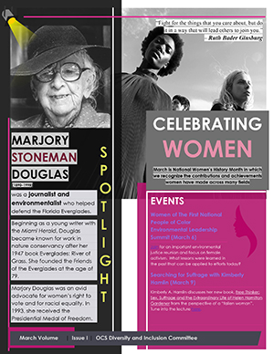
During the month of March, the OCS Diversity and Inclusion Committee Spotlight series, features the ladies to honor and celebrate Women's History Month. Women have been contributing to NOAA for over 150 years. This week our spotlight is on journalist and environmentalist, Marjory Stoneman Douglas, who helped defend the Florida Everglades.
The USC Wrigley Institute proudly presents the webinar Women, Science, and the Road to Inclusive Leadership.
Date: Thursday, March 11, 2021
Time: 12:00 p.m. (PST)
The NOS Office of EEO and Diversity Programs are offering training, Innovation and Creativity in the Workplace.
Date: Thursday, March 11, 2021
Time: 10:00-11:30 a.m. and 2:00-3:30 p.m. (EST)
Please sign up here and select one of the sessions.
The University of South Florida is offering a certification in Diversity, Equity, and Inclusion in the Workplace.
Date: Wednsday, March 24 through Wednesday, May 5, 2021
Time: 5:00-7:00 p.m. (EST)
The certificate program consists of seven, 2-hour modules, aired live on Wednesday. Advanced registration is required.
NOAA Safety and Health Week Challenge Events
Date: March 15-April 15
Build or maintain your fitness over a 30-day period with the flexibility to be active at your own pace. Participate in any of four challenge events at beginner, intermediate or advanced levels: Fitness, Walking, Running, and Cycling

