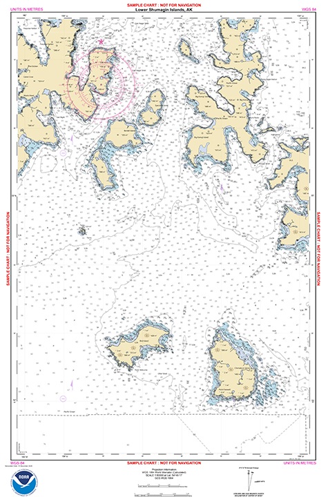
New large-scale NOAA ENC® of Alaska’s Shumagin Islands built from 40+ modern hydrographic surveys
Over a decade of hydrographic surveying around the Shumagin Islands, Alaska, has culminated in four new 1:80,000 NOAA electronic navigational charts (NOAA ENC®). The four ENCs include 37 systematic hydrographic surveys conducted by the NOAA ships
Fairweather and
Rainier, as well as NOAA contractors, one trackline survey by the NOAA Ship
Oscar Dyson, and six lidar surveys of depths and features near shore. This area was previously charted at 1:300,000 with very sparse depth or feature information that was not adequate to support safe navigation. Vessel traffic data showed that traffic was avoiding the area to some extent despite it representing a more efficient route in terms of distance. The ENCs US4AK3KT, US4AK3KU, US4AK3LT, US4AK3LT are based on the new “reschemed” gridded layout. They include standard whole meter depth contours 5m, 10m, 15m, 20m, 30m, 50m. Rescheming new NOAA ENCs is progressing for Alaska and all U.S. Coastal waters. In addition to all the efforts of hydrographers and the Hydrographic Surveys Division for collecting and processing the surveys, the ENCs were created by Marine Charts Division cartographers
LaTonya Wilson (compiled) and
Eric Wallner (reviewed). For more information contact
Andrew.Kampia@noaa.gov.
TeamCCOM wins Virtual Ocean Robotics Challenge

Virtual Ocean Robotics Challenge poster.
During the holidays, the results of the
Virtual Ocean Robotics Challenge were announced and “TeamCCOM” from the University of New Hampshire’s Center for Coastal and Ocean Mapping / NOAA Joint Hydrographic Center won first place! CCOM's team was composed of graduate student
Coral Moreno and staff engineers,
Roland Arsenault and
Val Schmidt. The competition was sponsored by Open Robotics, the Naval Postgraduate School and the Office of Naval Research and was held virtually, in a simulated environment provided by Open Robotics. The simulated venue was the port of La Spezia, Italy, and the hosts provided a complete simulated vessel with stereo cameras, lidar, USBL, GPS and motion sensor. Weather, including fog, wind, and waves were also simulated to add to the challenge. Thirteen teams entered Phase 1 of the competition, including teams from National University of Singapore, Georgia Institute of Technology, Panjab University - Chandigarh, the University of Hawaii. Just five teams completed the full competition.
The competition allowed the UNH team to rapidly develop methods and techniques that will be applied to the Bathymetric Explorer and Navigator, the University’s research ASV for Hydrography, and a new iXblue “DriX” ASV which will be delivered later this year.
For more information contact
Andy.Armstrong@noaa.gov.
New hydrographic surveying matching fund announced
Coast Survey recently announced a new pilot program for a Hydrographic Surveying Matching Fund opportunity through a
Federal Register Notice. The purpose is to encourage non-federal entities to partner with NOAA on jointly-funded hydrographic surveying, mapping, and related activities of mutual interest. The pilot program relates directly to
Coast Survey’s Ocean Mapping Plan and a goal to expand U.S. EEZ mapping by also expanding use of Coast Survey’s hydrographic services contract vehicle. The concept behind the pilot is that NOAA and partner(s) will match funds using a memorandum of agreement for NOAA to receive the funds. Coast Survey will rely on its existing contract arrangements to conduct the actual surveying and mapping activities. We expect this unique fund matching opportunity to expand our collaborative partnerships and mapping efforts while also serving to increase funds available for NOAA hydrographic contracts. Further details may be obtained in the federal register notice, but we encourage any additional questions to be sent to
iwgocm.staff@noaa.gov for follow-up.
NOAA seeks experts for hydrographic services advisory
panel membership for 2022
NOAA is soliciting nominations for membership on the
Hydrographic Services Review Panel (HSRP), a federal advisory committee that advises the NOAA administrator on the agency’s hydrographic programs, products, data, and technology. Nominations must be received by April 26, 2021, for a term that starts in 2022. Nominations are on a rolling admission and those received after April 26, 2021, will be kept on file and may be used for future panel vacancies. For more information on how to apply, see the
Federal Register Notice, visit the
HSRP website, or contact
Lynne.Mersfelder@noaa.gov.


Staff Updates

Joel Pfeiffer
The Pacific Hydrographic Branch welcomes
Joel Pfeiffer. Joel was born in New York and raised in Virginia. He began programming computers as an 8 year old, when his father (an electrical engineer working at General Electric) brought home an early generation Texas Instruments programmable scientific calculator. After finishing as an honor’s graduate from his local public high school, Joel headed to the University of Virginia to pursue a computer science degree, which was part of the engineering program at that time. Because science and medicine aligns more closely with his passions, he shifted gears and completed a biology degree with a pre-med focus. Joel then moved to Hawai’i via Santa Cruz, California, where he helped train and care for sea lions at Long Marine Laboratory. He began his post graduate studies at the University of Hawai’i at Manoa, entering the chemical oceanography master’s program under the School of Ocean and Earth Sciences. In conjunction with his graduate studies, he designed, built, and operated a coastal meteorological station at Bellow’s Air Force Base. Upon graduation, he accepted a position with Science and Technology International, Inc. as a hyperspectral imaging algorithm developer. During that time, he learned to fly small planes as part of his job description; something he hopes to continue as a seaplane pilot in Seattle. He also developed the algorithms and methodology to perform shallow water coral reef classifications to the 95% level of certainty using hyperspectral imagery. Joel joyfully returned to life as a physical scientist after working in his family’s business during his parents’ final stretch as owners. He gratefully accepted a job offer from NOAA’s Pacific Hydrographic Branch, located at the Western Regional Center in Seattle, Washington. After settling his affairs in Virginia, Joel drove across the U.S. in November of 2020, with entry on duty of December 7. He is excited to join the NOAA family and looks forward to all of the collaborative efforts that will contribute to making NOAA continually better.