Coast Survey supports arrival of USNS Comfort to New York City
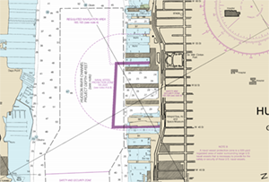
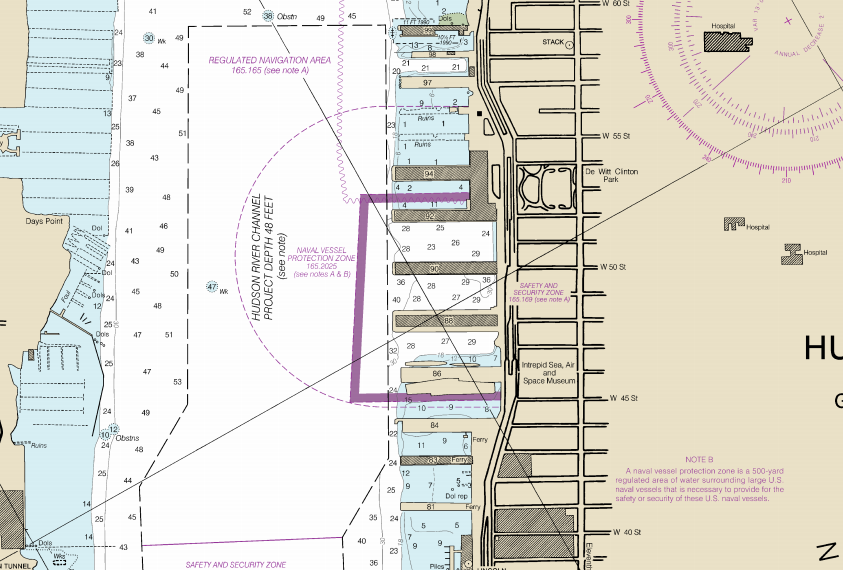
Coast survey updates New York charts with a protection zone
around the USNS Comfort.
The U.S. Navy's Military Sealift Command hospital ship, USNS
Comfort (T-AH 20), arrived in New York City on March 30 in support of the COVID-19 response efforts. The U.S. Coast Guard (USCG) Captain of the Port requested Coast Survey chart a naval vessel protection zone around the USNS
Comfort enabling USCG Sector New York to protect it. A naval vessel protection zone is a 500-yard regulated area of water surrounding large U.S. naval vessels that is necessary to provide for their safety or security. Normally, Coast Survey would not chart one for a temporarily-docked vessel, however, because of the extraordinary situation and the duration of the docking period may exceed six months, Coast Survey met this request.
Colleen Roche, NOAA's Northeast navigation manager, worked with the USCG Vessel Traffic Service, the USCG Sector New York chief of waterway management and chief of prevention, as well as the New York Harbor Safety Steering Committee to determine the most appropriate way to chart the request. Coast Survey's Nautical Data Branch and Marine Charting Division expedited the process. Raster charts now depict the new naval vessel protection zone and an updated NOAA electronic navigational chart (NOAA ENC®) will follow shortly. For more information contact
Colleen.Roche@noaa.gov or
Allison.Wittrock@noaa.gov.
NOAA certifies San Francisco Bay shipping channel with top survey rating, increasing confidence for deep draft vessel navigation
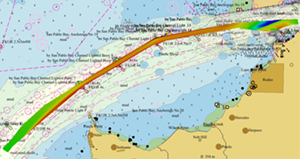
High-resolution bathymetry of Pinole Shoal Channel collected
by the USACE overlaying NOAA electronic navigational charts
US5CA31M and US5CA32M.
Mariners rely on many inputs for safe navigation, including the depths, contours, and hazards represented on NOAA ENCs. NOAA ENCs convey a data quality indication to the mariner known as a Category Zone of Confidence (CATZOC) rating, which indicates whether data meets a minimum set of criteria for position, depth accuracy, feature detection, and seafloor coverage. The San Francisco Bay Harbor Safety Committee sent a request to
Jeff Ferguson, NOAA’s California navigation manager, that NOAA work with the U.S. Army Corps of Engineers (USACE) to improve the CATZOC in Pinole Shoal Channel, a critical waterway for bulk carriers and tankers in that area.
Cmdr. Olivia Hauser, chief of Coast Survey’s Pacific Hydrographic Branch (PHB),
Katrina Wyllie, operations team lead for National Bathymetric Source, and
Peter Holmberg, Products Team Lead with PHB, worked extensively with USACE personnel in reviewing a full coverage survey of Pinole Shoal Channel. Verification of the data quality and USACE’s cooperation in providing additional metadata and features deliverables enabled Coast Survey to attribute the Pinole Shoal Channel with CATZOC A1 data quality for two years. NOAA anticipates the increased CATZOC rating will dramatically increase shipping efficiency. Visit our
blog for the full story. For more information contact
Jeffrey.Ferguson@noaa.gov or
Olivia.Hauser@noaa.gov.
Coast Survey international efforts progress virtually
John Nyberg led the WEND meeting from home this year.
This month, Coast Survey is continuing to progress its international endeavors, especially its
International Hydrographic Organization (IHO) partnership, through virtual meetings. The
Worldwide Electronic Navigation Database Working Group (WEND), chaired by
John Nyberg, chief of the Marine Chart Division (MCD), met virtually on April 7-9, gathering approximately 30 participants across several time zones (Asia, Europe and the Americas). Participants discussed governance, coordination, production, and distribution of new digital data, products and services which include information about tide water levels, surface currents, high-resolution bathymetry as well as nautical publications. These can be supported within the S-100 framework and will be used on bridges when the new S-101 ENCs become available. Key accomplishments this week resulted in a new framework for the WEND principles following a tiered approach and incorporating the
UN-GGIM's Implementation Guide for Integrated Geospatial Integrated Framework (IGIF) resulting in the WEND100. Additionally, the U.S. will organize and convene a two-hour
Arctic Regional Hydrographic Commission (ARHC) Intersessional meeting virtually in mid-April to discuss ARHC activities and updates on the ARHC10 meeting scheduled for August, among other things. The Intersessional was originally scheduled for Wednesday, April 22, at the
IHO Second Assembly in Monaco, which is postponed to November, 2020. For more information on WEND, please contact
Julia.Powell@noaa.gov, and for information on ARHC or other international matters contact
Jonathan.Justi@noaa.gov.
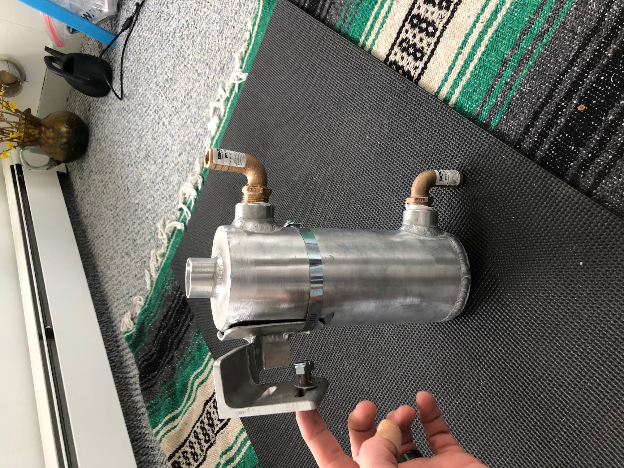
Navigation response team develops new methods for collecting sound velocity data
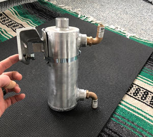
Prototype of the sea chest for the sound velocity probe.
NOAA's navigation response team (NRT) homeported in New London, Connecticut, designed a new system for collecting sound velocity data. Sound velocity is routinely collected as part of every hydrographic survey. The two methods currently employed for collecting sound velocity data limit the survey vessel's speed or reduce data accuracy. Additionally, aeration can be an issue which impacts data quality. In order to address these issues, NRT-New London designed a sea chest that is mounted to sit in line with the seawater intake for the boat's generator. The sound velocity probe is sealed within the sea chest. Under this new design, the team hopes to obtain accurate, real -time sound velocity data. Additionally, this system will improve safety on the NRT vessels, as the sea chest will remain in the water during the entire survey rather than requiring instruments be deployed and pulled from the water each time a sound velocity measurement is needed. NRT-New London plans to test their design once field operations resume. For more information
Lt. Dylan Kosten at
Dylan.Kosten@noaa.gov.
U.S Committee on the Marine Transportation System releases new report
The U.S. Committee on the Marine Transportation System (CMTS)
released a new report,
An Economic Analysis of Spending on Marine Transportation System (MTS) Infrastructure (April 2020), conducted by Inforum at the University of Maryland. The report demonstrates that increasing investment in themarine transportation system (MTS) infrastructure above a business-as-usual scenario will improve U.S. economic performance. Specifically, we can expect additional MTS investment to deliver higher levels of GDP, more jobs, increased incomes, improved trade performance, and higher productivity. “This report illustrates that our marine transportation system is an essential part of the Blue Economy and the Nation’s GDP, making a persuasive argument for how infrastructure investment could aid in economic growth,” said Rear Adm. Tim Gallaudet, assistant secretary of commerce for oceans and atmosphere, deputy administrator of the National Oceanic and Atmospheric Administration, and chair of the CMTS Coordinating Board. For more information contact
Pat.Mutschler@cmts.gov.
Ocean mapping briefing with the House Science Committee
On April 6, Coast Survey virtually briefed the House Science Committee staff on ocean mapping.
Rear Adm. Shep Smith used the
Ocean Mapping Capabilities document and the
Progress Report of Unmapped U.S. Waters to highlight how bathymetric data is collected and why ocean mapping is important and the many ways Coast Survey is rising to meet the need ocean mapping data. In addition to the topics highlighted in those documents, Rear Adm. Smith,
Ashely Chappell (Integrated Ocean and Coastal Mapping program manager), and
Capt. Rick Brennan (chief of HSD) answered questions related to Coast Surveys partnerships with other NOAA offices, with other federal agencies, with industry partners, and with academia. Briefings such as this are a valuable opportunity for Coast Survey to highlight the important work we do to Congress. For more information contact:
Amanda.Phelps@noaa.gov.
NOAA Ships and Contractor Operations
Weekly Hydro Ship Activity Report - Week of March 29 - April 3, 2020
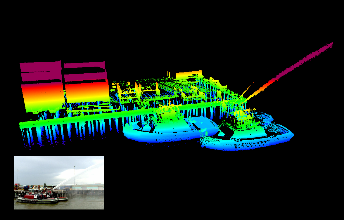
Featured Image:
Mobile mapping laser scanner (lidar) data acquired by NOAA NOS contractor David Evans and Associates, Inc. (DEA) as part of a high-resolution hydrographic survey of the lower Mississippi River in Louisiana between Baton Rouge and the entrance to Southwest Pass. The vessel-based mobile laser scanning data was used to update traditional shoreline and nearshore features, as well as heights of bridges and overhead cables that could pose a hazard to surface navigation. The image provides an example of the extreme level of detail that was achieved, catching a local tug testing its fire-fighting capabilities off of Milan Street Wharf in New Orleans. For more information contact
Jeffery.Marshall@noaa.gov.

Coast Survey Teams Find Ways to Stay Connected From Home

"Learn from a Co-worker webinar.
Coast Survey's Navigation Response Branch (NRB) hosts twice-weekly "Learn from a Co-worker" sessions. During a sesssion, a team member facilitates a 20-30 minute conversation on a topic related to NRB operations. These regular check-ins maintain branch buy-in and survey operational readiness, while fostering relationships with co-workers stationed around the country. Additionally, representatives from the Hydrographic Systems and Technology Branch also attend. Topics have included sound velocity probe and sea chest development, vessel static offsets, and side scan contacts (among many others). For more information contact Lt. j.g. Michelle Levano at
Michelle.Levano@noaa.gov.
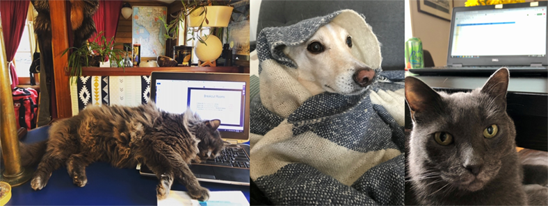
Left to Right: Capt Grey Ghost, Chance, and Katya are thrilled to finally be part of the Coast Survey team.
To share how your team is staying connected, email
Christine.Burns@noaa.gov.