Nautical charts depict new entrance channel for Huntington Harbour, California
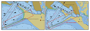
Image comparing the previous chart on the left and the current
chart on the right.
The Navy recently dredged a new channel into Huntington Harbour, California. The new channel provides access for recreational boaters into the harbor without the need to transit around naval vessels tied up at the U.S. Weapons Station at Seal Beach. Previously, recreational boaters used the existing entrance channel leading into Anaheim Bay, passing alongside the facilities and vessels of the weapons station, and continuing on into Huntington Harbour. The new channel allows recreational boaters to bypass Anaheim Bay and the weapons station completely. The Navy requested an update to the Coast Survey chart specifically in that area as soon as possible. The whole process went quickly, about three months from collecting hydrographic data to an updated product in the customer’s navigation system. By December 9, 2021, the new channel was shown on Coast Survey’s navigational charts of the area. The Navy has said of the process, "Outstanding news! From a boater public safety standpoint, this update was absolutely key. Thanks again for all of your help!." For more information contact
Jeffrey.Ferguson@noaa.gov.
Navigation Response Branch continues onward to Antarctica via New Zealand
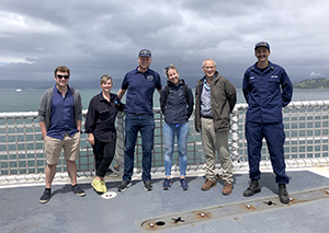
Members of NRB and LINZ shown standing from left to right:
Stuart Caie (LINZ), Annemeike Raymond (NOAA/OCS), Michael
Bloom (NOAA/OCS), Verena Bosselmann-Borsos (LINZ),
Bradley Cooper (LINZ), ENS Collin McMillian (NOAA/OCS).
Members of Coast Survey’s Navigation Response Branch (NRB),
Annemeike Raymond,
Michael Bloom, and
ENS Collin McMillian, arrived in Wellington, New Zealand aboard the U.S. Coast Guard Cutter
Polar Star on December 15, 2021. As part of this port call, they met with members of
Land Information New Zealand (LINZ), which is also the New Zealand Hydrographic Office. The members from LINZ provided the team with valuable information about McMurdo and Scott base as well as offering tidal data from their tide station in the region. On December 26, 2021, the team departed New Zealand and headed south. They arrived at McMurdo Station on January 11, 2022. The
Polar Star is currently engaged in cutting a channel to the station, but intends to begin survey operations next week. Interest in NOAA aboard the ship has been very high, and the info session that NRB personnel held was one of the most highly attended of all sessions during this run south. For more information contact
Chief.NRB.OCS@noaa.gov.
NOAA Hydrographic Services Review Panel announces public meeting and calls for nominations
The NOAA Hydrographic Services Review Panel (HSRP) Federal Advisory Committee has announced its virtual public meeting, which will take place on March 9 and 10. Please register for the NOAA HSRP Spring meeting at
this registration link. Additional meeting information
will be posted here. NOAA HSRP has also announced the 2023 call for nominations to request help in identifying a pool of very well qualified candidates who may be interested in submitting a nomination to the NOAA HSRP for a four year term beginning January 1, 2023. Additional information on nominations can be found
at this link. Nominations are due via email no later than April 15, 2022 and are limited to eight pages, require a cover letter with responses to five questions, a short biography, and a resume. Candidates are strongly encouraged to submit early, as there is a rolling admission. If the April 15 deadline is missed, nominations will be kept on file for future HSRP panel openings. For more information please contact
Lynne.Mersfelder@noaa.gov@noaa.gov.
Coast Survey participates in multi-agency talks with Japan on development and conservation of natural resources
The 49th meeting of the Sea Bottom Surveys Panel, U.S./Japan Cooperative Program in Natural Resources, met on January 11 and 13 to discuss the development and conservation of natural resources through cooperation in applied science and technology. The participants included the National Geodetic Survey, Office of Oceanic and Atmospheric Research, National Centers for Environmental Information, the University of New Hampshire, the National Geospatial-Intelligence Agency, and the Office of Coast Survey, with RADM Benjamin Evans chairing the event. The U.S. reported on NOAA priorities, mapping updates and chart transition, updated services, data access techniques, and activities with autonomous systems. Representatives from Japan included the Japan Coast Guard, Japan Agency for Marine-Earth Science and Technology, National Institute of Advanced Industrial Science and Technology, National Maritime Research Institute, Ministry of Defense, and The University of Tokyo. For more information contact John.Nyberg@noaa.gov.
Hydrographic Surveys Division prepares for 2022 field season
The Hydrographic Surveys Division has been busy preparing for the 2022 field season. They recently awarded their first hydrographic surveying contract for the 2022 field season which consists of survey work in the vicinity of Cape Newenham, Alaska. The 2022 Field Procedures Workshop is scheduled to be held February 1-3 via webinar. The first session on Tuesday 2/1 is open only to NOAA employees and NOAA affiliates working directly under NOAA. The second and third sessions on Wednesday and Thursday, 2/2 and 2/3, are open to everyone. If you are interested in attending, please register in advance for
Tuesday or
Wednesday/Thursday. For more information contact
Starla.Robinson@noaa.gov.
2022 Canadian Hydrographic Conference call for abstracts
The call for abstracts to participate in the
Canadian Hydrographic Conference is still open. You are warmly invited to
submit an abstract of recent research, development project, or innovative field work findings for either an oral or a poster presentation. The deadline for abstract submission is February 6. The conference will be held on June 6-9 in Gatineau, Canada – virtual participation will also be possible. Join professionals from all over the world, and be part of an open and inclusive dialogue on emerging research and good practices in hydrography!

Staff Updates

Scott Sherman
As of the new year,
Scott Sherman has officially transferred to the Information Technology Services Branch and will be the new web systems administrator. In this new position he will be responsible for typical webmaster duties, technical server infrastructure, web application programming, and website security. A big thanks to Scott for supporting Coast Survey in both the portfolio manager and webmaster roles since David Barglow's retirement in August. CSDL will look to backfill the portfolio manager role with a detail to be announced early in the new calendar year. Congratulations Scott!
Clint Marcus
In December 2021,
Clint Marcus graduated from the University of New Hampshire as part of the NOAA/CCOM-JHC Full-time University Training program. Clint earned his Master's Degree in Earth Science: Ocean Mapping and IHO CAT-A certification. Congratulations Clint and welcome back to HSD!