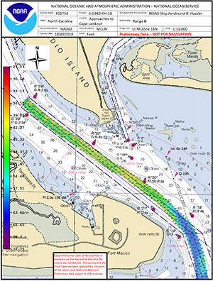
NOAA charts new hazards to help ports recover following Hurricane Florence
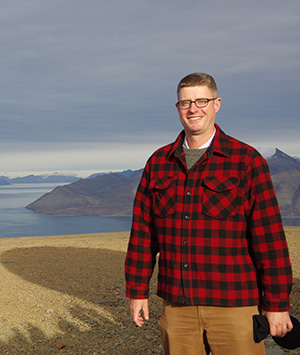
James Kirkpatrick, team lead of NRT – Fernandina Beach,
surveys the Cape Fear River following Hurricane Florence.
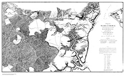
While conducting hydrographic surveys at the request of the U.S. Coast Guard following Hurricane Florence, Coast Survey’s navigation response teams and NOAA Ship Ferdinand R. Hassler with Coast Survey physical scientist staff onboard, found many underwater obstructions. Four obstructions in particular, found in the Cape Fear River channel, were identified as dangers to navigation. While these hazards remained in place when the port reopened, NOAA updated its charts and distributed them to the port, Coast Guard, and key stakeholders, allowing large vessels to safely navigate into port. The time from the survey to the publication of the chart was less than 24 hours, an unprecedented accomplishment for Coast Survey. Visit our
blog for the full story. For more information contact
James.M.Crocker@noaa.gov or
Mike.Brown@noaa.gov.
Improving storm surge modeling to support public safety
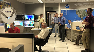
National Hurricane Center briefs the Secretary of
Commerce, Wilbur Ross (who is located remotely at the
National Centers for Environmental Prediction), on storm
surge projections on September 13, 2018.
The Coast Survey Development Lab provided storm surge modeling expertise to the National Hurricane Center in Miami, Florida, ahead of and following Hurricane Florence.
Dr. Sergey V. Vinogradov,
storm surge modeling lead, provided visualizations of storm surge simulations using the Hurricane Surge On-demand Forecast System for each forecast cycle of Hurricane Florence. Hindcast simulations were performed following the storm, to validate the model performance. This work contributed to storm surge predictions and inundation information, ultimately supporting public safety. For more information contact
Sergey.Vinogradov@noaa.gov.
GEBCO-Nippon Foundation Alumni Team completes successful 24-hour sea-trials ahead of $7 million XPRIZE final
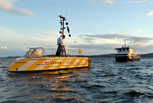
The team's concept sets sail from Horten, Norway, on the
first of three 24-hour sea-trials.
The GEBCO-Nippon Foundation Alumni Team
successfully completed its first 24-hour sea-trials in preparation for the final round of the Shell Ocean Discovery XPRIZE. The team, including 15 alumni of the GEBCO-Nippon Foundation postgraduate training program based at the Center for Coastal and Ocean Mapping (CCOM), University of New Hampshire, is led by
Dr. Rochelle Wigley, CCOM’s GEBCO project director. The purpose of the sea trials is to assess various operating procedures and fine-tune its entry before the final round in November-December at a secret location yet to be announced by the Shell Ocean Discovery XPRIZE. The $7 million XPRIZE is a global competition challenging teams to advance deep-sea technologies for autonomous, fast, high-resolution ocean exploration. For more information contact
Andy.Armstrong@noaa.gov.
Navigation response team lead presents survey results to Lower Columbia Harbor Safety Committee
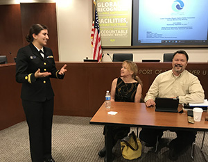
Lt. j.g. Michelle Levano presents survey progress to members
of the Lower Columbia Region Harbor Safety Committee
At the request of the Columbia River pilots, NOAA’s navigation response team stationed in Seattle has been
surveying 14 Columbia River Anchorages since June 2018.
Lt. j.g. Michelle Levano, response team lead, traveled to Vancouver, Washington, to present survey progress to date, preliminary results, and future plans at the Lower Columbia Region Harbor Safety Committee meeting. Eight of the 14 anchorage areas have been completed, with the remaining to be completed this fall. Meeting attendants were particularly interested in potential shoaling areas within the river, and any new dangers to navigation that were located. This data will help determine the size and number of vessels that the river can maintain at a time. In the future, the river will support more cruise ships, Coast Guard vessels, and larger merchant ships than it has historically experienced. The team’s data from the Columbia River survey will help CO-OPS determine future placement of benthic current meters and new tide gauge locations throughout the river. For more information contact
Michelle.Levano@noaa.gov.
Coast Survey coordinates hydrographic activity among Arctic member states
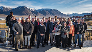
Members of the Arctic Regional Hydrographic Commission
meet in Longyearbyen at Svalbard, Norway.
Rear Adm. Shepard Smith,
Lt. Cmdr. Sam Greenaway, and
Jonathan Justi attended the Eighth Conference of the
Arctic Regional Hydrographic Commission in Longyearbyen at Svalbard, Norway, to coordinate hydrographic activity among member states—Canada, Denmark, Norway, Russia, and the United States—in the Arctic region. The meeting focused on international charting considerations, crowdsource bathymetry, autonomous systems, and marine spatial data infrastructure and policy. The International Hydrographic Organization (IHO) encourages the establishment of Regional Hydrographic Commissions (RHCs) to coordinate hydrographic activity at the regional level. The RHCs are made up of IHO member states and other regional states that meet at regular intervals to discuss the resolution of mutual hydrographic and chart production problems, plan joint survey operations, and resolve schemes for medium- and large-scale international chart coverage.
For more information contact
Jonathan.Justi@noaa.gov.
Coast Survey meets with hydrographic survey contractor to discuss survey operations in Tampa Bay
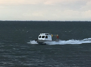
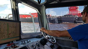
Meredith Payne and Starla Robinson participated in side scan
sonar data acquisition on the small survey vessel C-Wolf.
Hydrographic Surveys Division Operations Branch physical scientists,
Meredith Payne and
Starla Robinson teamed up with western Gulf coast navigation manager, Tim Osborn, to visit contractor, Oceaneering International Inc., on the site of the Approaches to Tampa Bay, Florida, hydrographic survey project. Data acquired in the 660 square nautical mile project area will serve the interests of local pilots, recreational mariners, coastal managers, and habitat conservationists, as well as providing much-needed updates to nautical charts. Meredith and Starla discussed details of survey operations with the Oceaneering field crew and also participated in side scan sonar data acquisition on the small survey vessel
C-Wolf. Tim Osborn, a native of the Tampa Bay region, acquainted Oceaneering managers with St. Petersburg and related the importance and impact of the survey area to the Florida economy and its residents. The Ports of Tampa Bay supply over 40% of the fuel arriving in Florida, which is currently the second fastest-growing state in the U.S. With the exception of Egmont Channel, the majority of chart data for this region dates back to the twentieth-century or older. Additionally, this area is particularly vulnerable to large storm events--four have struck the region in the past three years. All of these factors add up to making this a crucial location for modern survey data. For more information contact
Meredith.Payne@noaa.gov.

NOAA Ships and Contractor Operations
Weekly Hydro Ship Activity Report - September 16 - 25, 2018
Ship Highlight: NOAA Ship Ferdinand R. Hassler surveys approaches to Wilmington and Morehead City to help speed the reopening of ports following Hurricane Florence
Survey progress by Ferdinand R. Hassler at the Approaches
to Wilmington following Hurricane Florence.
On September 10,
NOAA Ship Ferdinand R. Hassler broke from their hydrographic survey of the Approaches to Jacksonville and transited from offshore of Amelia Island to Charleston, South Carolina, to prepare for Hurricane Florence and stage for recovery response. Immediately after the storm’s passage, the ship departed to assist in the recovery effort, surveying shipping channels in Charleston, South Carolina, and the North Carolina entrance channels to Wilmington, Morehead City, and Wrightsville. Of the Hurricane Florence responding fleet,
Hassler has the greatest endurance for time deployed at sea; and can withstand the greatest sea state with an operational limit of 8 feet. This makes
Hassler an ideal responder for open waters, such as port entry channels.
Hassler is commanded by
Lt. Cmdr. Matt Jaskoski and is one of only four NOAA ships that is capable and ready to respond to emergency hydrographic surveys. Coast Survey physical scientists
Starla Robinson and
John Doroba were on board during the response period assisting with survey and data processing efforts. For more information contact
Starla.Robinson@noaa.gov.
Navigation Response Teams
NRT 1 - Cleaning and repacking systems post-Hurricane Florence and traveling to the Department of Commerce Gold Honors Ceremony.
NRT 2 - Processing data post-Hurricane Florence and preparing for surveying in Florida.
NRT 3 - Deployed to
Marine Operations Center - Pacific to help with autonomous launch conversion.
NRT 4 - Preparing for survey in Houston/Galveston area and
Flower Gardens Banks National Marine Sanctuary.
NRT 5 - Processing data post-Hurricane Florence, getting ready for routine surveying.
Bay Hydro II - Surveying Delaware Bay.
NRT Highlight: Teams face safety and logistical challenges while traveling to response areas following Hurricane Florence
Rapidly rising rivers and unprecedented rainfall amounts that came with Hurricane Florence posed significant safety and logistical challenges throughout Coast Survey’s response efforts. On the morning of September 16, NRT 2 safely made their way into Wilmington, North Carolina, just hours before the city was completely cut off from the rest of the state by rising flood waters. NRT 5 made their push into Morehead City, monitoring road closures and coordinating closely with U.S. Coast Guard units that had successfully made it into Morehead City earlier that morning. Coast Survey’s Navigation Response Branch (NRB) headquarters continually monitored river levels and flow predictions for North Carolina rivers using information from the
NOAA Advanced Hydrologic Prediction Service and monitored
North Carolina Department of Transportation road closures website to help route teams to their destinations. Thank you to our teams that responded including NRT2:
James Kirkpatrick (team lead),
Lucas Blass,
Howie Meyers, and
Doug Wood; NRT 5:
Lt. j.g. Dylan Kosten (team lead),
Eli Smith,
Michael Bloom; NRT 1/MIST:
Joshua Bergeron,
Alex Ligon,
Mike Annis (MIST lead). For more information contact
Michael.Davidson@noaa.gov.

Awards
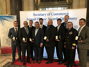
Department of Commerce Gold Honor Award recipients and
NOAA leadership (from left to right: Jonathan French, Mike
Annis, Cmdr. Chris van Westendorp, John Doroba, Eli Smith,
Josh Bergeron, Rear Adm. Tim Gallaudet (Navy, ret.), Michael
Bloom, Rear Adm. Shep Smith, Kyle Ward)
On Tuesday, September 25, Department of Commerce Gold Honors Awardees received their medals at a ceremony in Washington, DC. Congratulations
Kyle Ward,
Mike Annis,
John Doroba,
Michael Bloom,
Jonathan French,
Eli Smith, and
Josh Bergeron for their outstanding dedication, expertise, and professionalism while volunteering at short notice and under challenging conditions to form the Mobile Integrated Survey Team during the aftermath of hurricanes Harvey, Irma, and Maria.
Cmdr. Chris van Westendorp, commanding office of NOAA Ship
Thomas Jefferson, also attended the ceremony accepting the medal on behalf of the ship in recognition of their exemplary hurricane response to Puerto Rico.