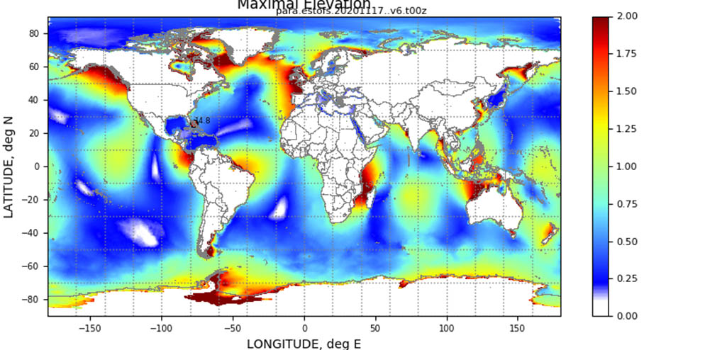
Extratropical Surge & Tide Operational Forecast System (ESTOFS) is now global

An example of maximum forecast water levels (m MSL)
from a forecast cycle of Global ESTOFS.
On November 24, an upgrade to
Global ESTOFS was implemented to provide NWS forecasters with high resolution water level forecast guidance including storm tide (storm surge plus tides) for the entire globe. Global ESTOFS forecast guidance will be used by forecasters at WFOs and the
Ocean Prediction Center (OPC) to generate their storm surge forecasts during winter storms including Nor’easters along the U.S. East Coast. With this upgrade, the model is global for the first time and replaces a previous version with three operational domains in the Atlantic, Pacific and Micronesia regions. The model also now offers improved spatial resolution in U.S. waters and enhanced physics. The model has four forecast cycles per day, providing water level forecast guidance out to 180 hours. ESTOFS is one of the oldest-running coastal storm surge operational forecast systems, in place operationally since 2012. The system was developed by Coast Survey's
Coastal Marine Modeling Branch and was implemented in collaboration with the National Weather Service and University of Notre Dame. Global ESTOFS’ new capabilities were implemented during collaborative research and development projects supported by the NOAA Water Initiative, COASTAL Act and NOS’ Office of Coast Survey research opportunities. For more information visit our
blog or contact
Edward.Myers@noaa.gov.
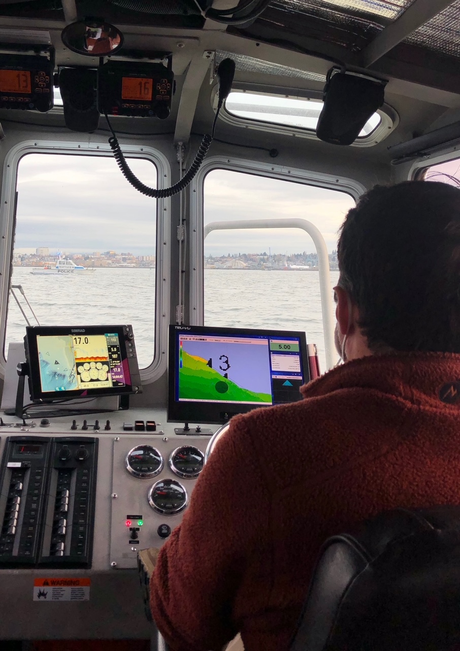
Navigation Response Team assists in search for victim of capsized vessel
PST Timothy Wilkinson operating response vessel S3006
alongside numerous law enforcement vessels. Photo Credit:
PST Annemieke Raymond.
Physical science technicians (PST),
Annemieke Raymond and
Timothy Wilkinson, alongside a dozen government agencies, four local tribes, and countless volunteers, responded to a search for a missing Tulalip Tribal Police Department officer. Officer Charlie Cortez was on duty when a rogue wave walloped the 26 ft fisheries vessel he, and Officer Shawn Edge were underway in, on a chilling night in November. The two officers were using their department's 26-ft skiff to respond to a distress call from a non-tribal boat owner, when their boat capsized. Officer Edge was recovered from the water by a fishing vessel that night. Officer Cortez is presumed to have drowned, his family and community are in our thoughts. For more information contact
Michelle.Levano@noaa.gov.
21st Meeting of the Meso American-Caribbean Sea Hydrographic Commission hosted virtually by the U.S.
MACHC meeting logo.
The U.S. (NOAA Office of Coast Survey, U.S. Navy, and National Geospatial-Intelligence Agency) hosted the first ever virtual 21st meeting of the
Meso American-Caribbean Sea Hydrographic Commission (MACHC) from November 30 to December 3, 2020. The meeting gathered approximately 90 participants each day, representing 22 Caribbean region nations. Due to the virtual nature of MACHC-21, a streamlined agenda was created with Member and Observer country input. The U.S. organizers engaged participants by using an interactive webinar platform, Interactio, which allowed for breakout sessions and simultaneous translation during the meeting. MACHC-21 focused on ensuring seamless regional electronic navigational chart coverage, increasing capacity to provide the best quality navigation products and services, and making invaluable, authoritative charting data available for many other non-navigation purposes, as reflected in the
opening video. Industry support presentations related to these focal areas were included throughout the meeting. Other major topics included IHO and MACHC developments and policies, disaster response, and Seabed 2030 and crowdsourced bathymetry, including regional contributions to Seabed 2030, which seeks to map the world’s entire ocean floor by 2030 as part of the United Nations Decade for Ocean Science. The
MACHC-IOCARIBE Seabed2030 Strategy and
2021 Implementation Work Plan were officially unveiled and approved, making the MACHC the first regional hydrographic commission to have a plan for completing a bathymetric map by 2030 that informs the sustainable, multi-purpose use of the regional ocean.
Katie Ries, Coast Survey deputy director, has served as the MACHC chair since 2018 and completed her term at the closing of MACHC-21, passing along the chairmanship to Rear Adm. Edgar Luiz Siqueira Barbosa of Brazil. The U.S. hopes that circumstances will allow the hosting of an in-person 22nd Meeting of the MACHC in one of two potential major port and cultural areas in the U.S. in 2021: either Miami, Florida, or New Orleans, Louisiana. Please find a virtual group photo of the 21st meeting of the MACHC
here.
For more information contact
Kathryn.Ries@noaa.gov.
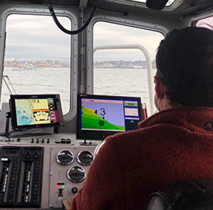
Coast Survey presents the latest in its products and services to the Seven Seas Cruising Association
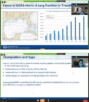
Colby Harmon and Steve Soherr alongside their presentation
slides during the Seven Seas Cruising Association webinar.
On December 10,
Colleen Roche,
Steve Soherr, and
Colby Harmon presented during a webinar to the Seven Seas Cruising Association (SSCA) on a range of topics including existing NOAA chart products and services, the transition from the raster navigation products and traditional paper charts to the ENC, as well as other boater resources such as the NOAA Custom Chart, online viewers, and the ASSIST interface. The webinar was attended by approximately 100 SSCA members, a number of NOAA employees, and representatives from the companies of GEC, which produce the Aqua Map navigation software, and Waterway Guide LLC. During the webinar, the Waterway Guide’s Robert Sherer also provided examples of problem areas identified along the Atlantic Intracoastal Waterway (AIWW), some of which may be resolved by using the latest USACE data to adjust the location of the magenta line. In summary, this webinar served as an excellent opportunity to share information with members of the recreational boating community, which represents a staggering number of stakeholders who use and rely on NOAA-based charts and data. Moreover, it provided Coast Survey with the opportunity to better understand boater concerns and to consider how those concerns might help direct our planning for a smooth transition to the ENC and away from traditional raster-based products. Recordings of the webinar are available for 30 days and can be downloaded from the following links:
For more information contact
Colleen.Roche@noaa.gov.
Coast Survey participates in the US-Japan Cooperative Program in Natural Resources 48th meeting
With
Rear Adm. Shepard Smith as chair, representatives of Coast Survey, the University of New Hampshire, and the National Geospatial-Intelligence Agency participated in the 48th meeting of the Sea Bottom Surveys Panel of the US-Japan Cooperative Program in Natural Resources (UJNR) on December 8 and 10. The panel promotes exchanges of marine geophysical and bathymetric research and survey data. Recently, the panel has focused on multibeam surveying, associated data gathering systems, disaster response hydrography, and electronic charting. NOAA reported on activities with autonomous systems, standards, data processing and management, technology innovations and oceanographic forecast modeling. Representatives from Japan included the Japan Coast Guard and the Japan Hydrographic Association. The objective of the UJNR program is to provide a continuing forum to promote the development and conservation of natural resources through cooperation in applied science and technology For more information contact
Andy.Armstrong@noaa.gov.
Alaska Coastal Mapping Strategy Implementation Plan focus of recent summit
The third Alaska Coastal Mapping Summit was held on December 9-10. It focused in part on the
Alaska Coastal Mapping Strategy (ACMS), released in June of 2020. NOAA's Integrated Ocean and Coastal Mapping Team (IOCM) including
Ashley Chappell and
Amber Butler, helped lead the event, with IOCM's
Meredith Westington and Alaska navigation managers (
Lt. Cmdr. Bart Buesseler, outgoing, and
Hadley Owen, incoming) participating for Coast Survey. Hosted by the Alaska Mapping Executive Committee Coastal Subcommittee and the Interagency Working Group on Ocean and Coastal Mapping, the summit built on the momentum for Alaska mapping and engagement through agency updates, public comments, and technical talks by the Alaska mapping community. Major themes of the summit included strategic coordination and the Alaska Coastal Mapping Strategy Implementation Plan. Summit attendees also learned about the NOAA Hydrographic Services Review Panel assessment of the ACMS. The Summit was attended by more than 150 coastal managers, planners, decision-makers, and other stakeholders from state, federal, local agencies, native corporations and associations, non-profit and professional organizations, academia, and private industry attendees. Forty speakers presented technical talks, facilitated discussions, and answered questions. Work continues on the ACMS Implementation Plan. It will be available for public comment in January 2021. For more information contact
Ashley.Chappell@noaa.gov.
Coast Survey's Navigation Managers meet to discuss engagement strategies
On December 7 and 9, Navigation Services Division's Customer Affairs Branch hosted a virtual meeting for the navigation managers. This abbreviated meeting focused on ways that navigation managers can better engage with congressional staffers and other local stakeholders in their regions. During this meeting, we were joined by Rear Amd. Shep Smith, Nicole LeBeouf, and representatives from the Center for Operational Oceanographic Products and Services, the National Geodetic Survey, and the U.S. Integrated Ocean Observing System, who shared ways that the navigation managers can support Coast Survey and National Ocean Serivce (NOS) priorities. We also learned about techniques for engagement with congressional staffers from NOS' Policy and Constituent and Affairs Division and NOAA's Office of Legislative Affairs. Finally, we had the opportunity to review Coast Survey's draft Legislative and Interagency Engagement Strategy. Thank you to
John Nyberg,
Amanda Phelps, and
Christine Burns for their assistance in planning this event. For more information contact
Lucy.Hick@noaa.gov.


Staff Updates
Steven Loy
Steven Loy (Steven, Steve, him/his) is a physical scientist with Hydrographic Survey Division Operations Branch. Steven grew up in eastern North Carolina along the intracoastal waterway, and currently resides in Seattle, Washington. Steve most recently worked for David Evans and Associates, Inc. as a lead hydrographer, conducting surveys for a variety of public and private sector clients. Steven spent nearly a decade as a NOAA Corps officer, with assignments on NOAA Ship
Fairweather, Navigation Response Team homeported in New London, NOAA Ship
Rainier, and with National Ocean Service headquarters staff. Steven has a bachelor’s in environmental science from the University of North Carolina at Chapel Hill, and a master’s in hydrographic science from the University of Southern Mississippi. Off work, Steven and his partner Michelle enjoy outdoor activities, motorcycling, and fostering dogs from our local animal shelter. He is excited to return to NOAA and public service in a new capacity and looks forward to working on unique projects with the amazing people here at NOAA. He can be reached at steven.loy@noaa.gov.
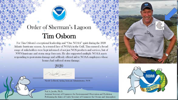
Awards

Tim Osborn's Silver Sherman Award certificate.
Congratulations to
Tim Osborn for receiving the Silver Sherman Award. NOS Assistant Administrator Nicole LeBoeuf presented Tim with the award for exceptional leadership and “one NOAA” spirit during the 2020 Atlantic hurricane season. As a trusted face of NAOA in the Gulf, Time ensured a broad range of stakeholders were kept informed of not just NOS products and services, but of NWS hurricane and storm surge forecasts. He also supported multiple NOAA assets responding to post-storm damage and selflessly offered aid to NOAA employees whose homes had suffered storm damage.
Opportunities
The following vacancy has been posted for the deputy chief of the Coast Survey Development Laboratory. If there are any questions, please direct them to
Shachak.Peeri@noaa.gov.
Supervisory Program Manager, ZA-0340-5
Position will be open for 10 days,
12/15/20 - 12/24/20
Job Announcement # (MAP): NOS-OCS-2021-0001