NOAA begins 2016 hydrographic survey season

New data will update nautical charts around the country

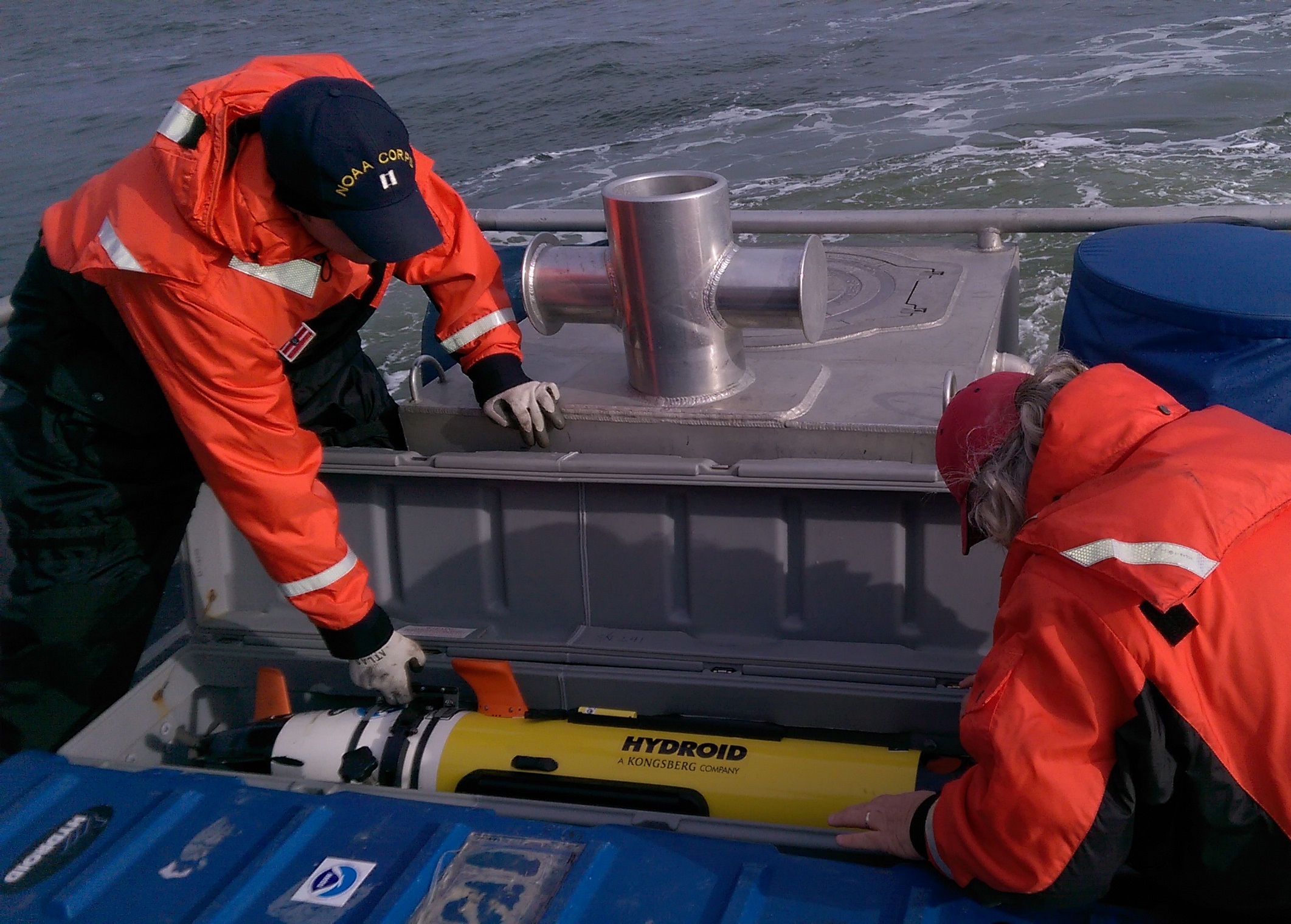
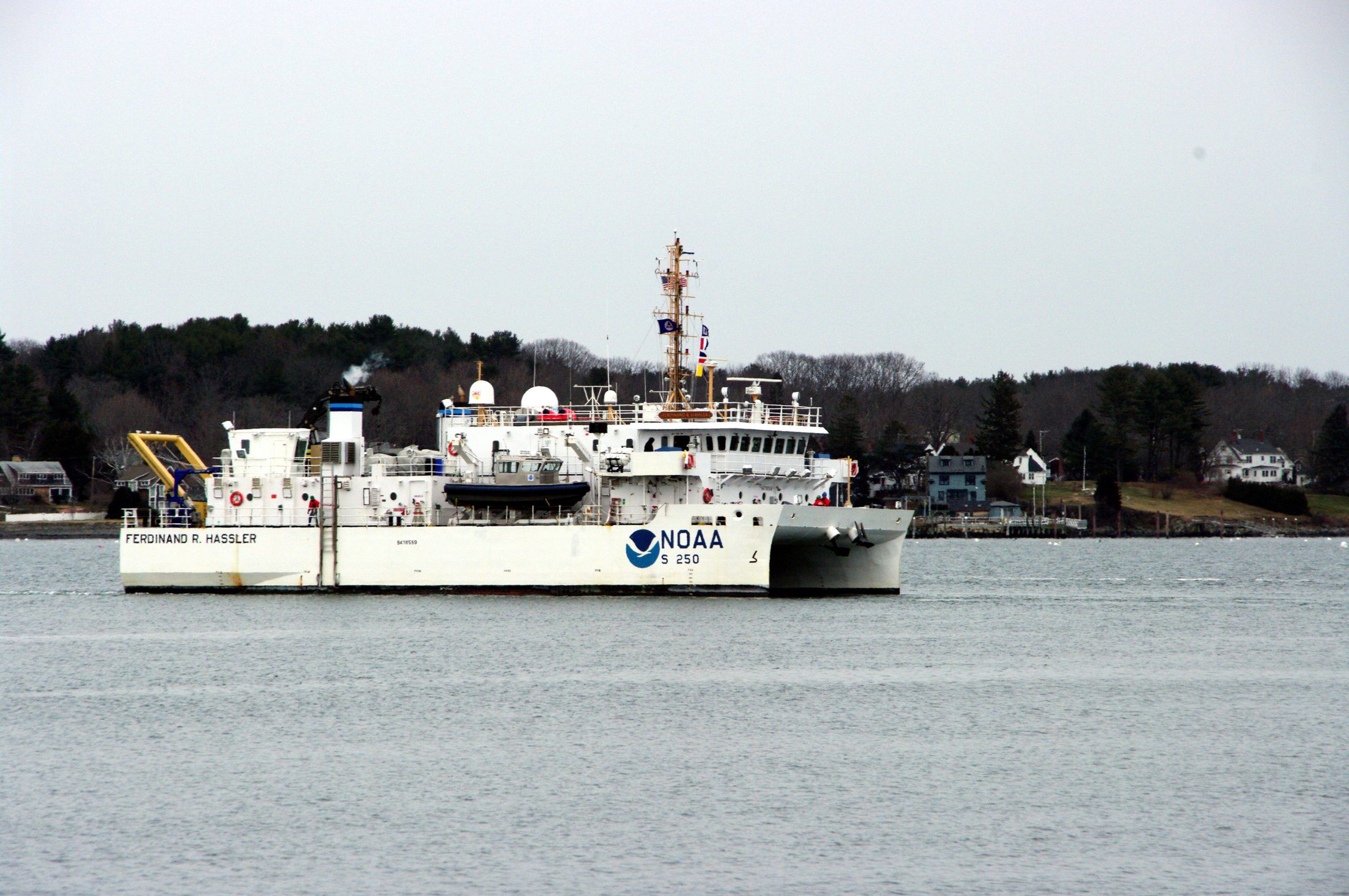
As sure as spring arrives, NOAA vessels and independent contractors are hitting the seas for the nation’s 182nd hydrographic surveying season, collecting data for over two thousand square nautical miles in high-traffic U.S. coastal waters.

NOAA Ship Ferdinand Hassler heads out to survey.

“Nautical charts are the foundation for the nation’s maritime economy, and NOAA hydrographers spend months at sea, surveying critical areas to ensure safe navigation for the shipping, fishing, and boating communities,” said Rear Admiral Gerd Glang, director of the Office of Coast Survey.
“Spring is the traditional beginning of the survey season,” Glang explained. “After a winter of data processing, ship maintenance, and personnel refresher training, the NOAA survey ships and Coast Survey navigation response teams are anxious to get to their survey assignments.”
Continue reading “NOAA begins 2016 hydrographic survey season”

New tips for understanding nautical chart symbols

SymbolGlobeAs a responsible boater, you examine your nautical chart before sailing, determined to avoid problems during a nice trip along the coast. Charts are packed with symbols and abbreviations, so you might refer to the free copy of U.S. Chart No. 1, which lists all of the symbols used on NOAA nautical charts. It is an excellent quick reference for identifying unfamiliar symbols.
However, sometimes mariners need a deeper understanding…
Coast Survey is now providing additional information about complex or particularly confusing chart symbols to augment what is available in U.S. Chart No. 1. The first two tip sheets are available now. Coast Survey will add more chart symbology tip sheets to the U.S. Chart No. 1 webpage as the need arises.
Continue reading “New tips for understanding nautical chart symbols”

Coast Survey uses unmanned technology to find submerged danger to navigation

AUV preparation

Coast Survey has been discovering and marking the locations of underwater dangers since our surveyors took the nation’s first official ocean soundings in 1834. We’ve used or developed all the technological advancements – lead lines, drag lines, single beam echo sounders, towed side scan sonars, and post-1990 multibeam echo sounders – and now we can point to a new major advancement for fast deployment and quick recovery. In February, Coast Survey’s Mobile Integrated Survey Team (MIST) used an autonomous underwater vehicle (AUV) to locate a submerged buoy that was interfering with anchorages in the Chesapeake Bay.
“You and the crew of the HASSLER put us right where we needed to be!” said a confirmation email from the U.S. Coast Guard to NOAA Lt. Ryan Wartick, one of Coast Survey’s navigation managers. “Thanks for the great work!”
Continue reading “Coast Survey uses unmanned technology to find submerged danger to navigation”

Happy 209th anniversary to the Office of Coast Survey, the oldest federal scientific organization

The Office of Coast Survey dates from 1807, when much of the commerce between the states was by coastal shipping. And all foreign trade, especially critical to our prosperity, had to come by ship. With so many ships coming into our ports and harbors, shipwrecks were common, and it was clear the young maritime nation needed accurate nautical charts.

NINTH CONGRESS OF THE UNITED STATES
At the Second Session,
Begun and held at the city of Washington, in the territory of Columbia,
on Monday the first of December, one thousand eight
hundred and six.

AN ACT to provide for surveying the coasts of the United States.

Be it enacted by the Senate and House of Representatives of the United States of America, in Congress assembled, that the president of the United States shall be, and he is hereby authorized and requested, to cause a survey to be taken of the coasts of the United States, in which shall be designated the islands and shoals, with the roads or places of anchorage, within twenty leagues of any part of the shores of the United States; and also the respective courses and distances between the principal capes, or head lands, together with such other matters as he may deem proper for completing an accurate chart of every part of the coasts within the extent aforesaid.
Continue reading “Happy 209th anniversary to the Office of Coast Survey, the oldest federal scientific organization”

Coast Survey announces surveys by navigation response teams

NRT data will be used to update nautical charts

Coast Survey’s navigation response teams have proven their value, time and again, especially after hurricanes when ports suspend operations, and shipping (or naval movements) cease until Coast Survey’s small boats can locate underwater dangers to navigation. But what do the six navigation response teams (NRTs) do during those long periods between deployments for maritime emergencies? They are busy, mostly year-round, collecting hydrographic data for updating nautical charts.
Continue reading “Coast Survey announces surveys by navigation response teams”

Storm surge model provides vital info for #Blizzard2016

NOAA runs operational forecast modeling systems that provide users with forecast guidance of water levels, currents, and water temperatures for the next 60 hours. The Extratropical Surge and Tide Operational Forecast System (ESTOFS), a storm surge model developed by Coast Survey in 2012, is a vital source of information for forecasting coastal flood events during this weekend’s blizzard.
See the ESTOFS output here, or check nowCOAST for model output integrated with other data.

Continue reading “Storm surge model provides vital info for #Blizzard2016”

Get your hands on science at the NOAA Open House

These kids had a great time getting their hands on science at last year's Open House.
These kids had a great time getting their hands on science at last year’s Open House.

Explore your world and learn how NOAA takes the pulse of the planet every day and protects and manages ocean and coastal resources. Join us on NOAA’s Silver Spring, Maryland, campus for a series of free activities, including engaging talks by NOAA experts, interactive exhibits, special tours, and hands-on activities for ages 5 and up. Meet and talk with cartographers, scientists, weather forecasters, hurricane hunters, and others who work to understand our environment, protect life and property, and conserve and protect natural resources. Learn some of Coast Survey’s heritage and see a historic printing press that we actually used to print charts in the 1800s.
Visit www.noaa.gov/openhouse for details or call 240-533-0710 for more information.
Continue reading “Get your hands on science at the NOAA Open House”

NOAA and Cuban chartmakers working together to improve maritime safety

Following up on Coast Survey’s visit to Havana last spring, Cuban hydrographic officials traveled to Maryland on December 15-17, to meet with NOAA National Ocean Service leaders for discussions about potential future collaboration. High on the agenda for Coast Survey is improving nautical charts for maritime traffic transiting the increasingly busy Straits of Florida.
The historic meeting began with Dr. Russell Callender, NOS acting assistant administrator, welcoming the Cuban delegation, led by Colonel Candido Regalado Gomez, chief of Cuba’s National Office of Hydrography and Geodesy.
Continue reading “NOAA and Cuban chartmakers working together to improve maritime safety”

Nigerian naval officer augments on NOAA survey ship

by Ensign Kaitlyn Seberger, Junior Officer, NOAA Ship Thomas Jefferson
This fall, NOAA Ship Thomas Jefferson has had the pleasure of hosting Sub-Lieutenant Uchechukwu Erege. Sub-Lieutenant Erege, known to the ship’s crew as “UK,” is a hydrographer in the Nigerian Navy Hydrographic Office. The Nigerian Navy Hydrographic Office is the national hydrographic authority for the country and is responsible for conducting hydrographic surveys in territorial waters, ensuring nautical charts are up-to-date, processing bathymetric data, and providing Notice to Mariners for hazards to navigation.
UK joined the Nigerian Navy in 2012 after graduating with distinction from the University of Lagos with a bachelor’s and master’s degree in geoinformatics. He then completed a 10-month training program at the Nigerian Defense Academy before transitioning to his current position in the hydrography branch.
Continue reading “Nigerian naval officer augments on NOAA survey ship”