
The federal Interagency Working Group on Ocean and Coastal Mapping recently released the fifth annual report on progress made in mapping U.S. ocean, coastal, and Great Lakes waters. Knowledge of the depth, shape, and composition of the seafloor has far-reaching benefits, including safer navigation, hazard mitigation for coastal resilience, preservation of marine habitats and heritage, and a deeper understanding of natural resources for sustainable ocean economies. The 2020 National Strategy for Mapping, Exploring, and Characterizing the United States Exclusive Economic Zone (NOMEC) makes comprehensive ocean mapping a priority for the coming decade. The Unmapped U.S. Waters report tracks progress toward these important goals.
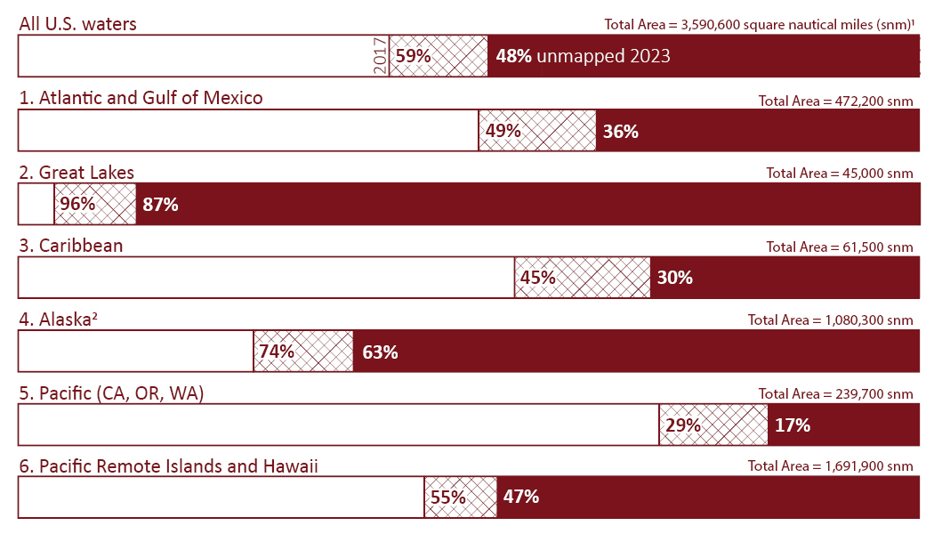
Pulling from an analysis of publicly available bathymetry, the report presents the percentage of unmapped U.S. waters by region and shows our progress towards filling these basic bathymetry data gaps with each passing year. At the end of 2023, 53,100 square nautical miles of new bathymetric data coverage were added since the last report, which moved us from 50% unmapped at this time last year to 48% unmapped.
Progress was made on a number of fronts, but most notably in areas where regional campaigns are established to facilitate collaborative data acquisition activities and increase data sharing, in accordance with the NOMEC Strategy goals.
Roughly half of the total coverage gains are in the Alaska region, where the Seascape Alaska campaign exists. NOAA hydrographic surveys in the Bering Sea, U.S. academic research surveys in the Gulf of Alaska and northward, as well as the first set of deliverables from the Seascape Alaska expeditions along the eastern Aleutian Islands are major contributors to those gains.
The Great Lakes, home of the Lakebed 2030 campaign, saw the largest percentage increase in new bathymetric data coverage. The region jumped from 92% to 87% unmapped, with much of that progress attributable to recent NOAA multibeam sonar hydrographic surveys and bathymetric lidar collection efforts in addition to the public release of recent US Army Corps of Engineers Joint Airborne Lidar Bathymetry Technical Center of Expertise lidar collections.
The Pacific Coast, home of the EXPRESS campaign, moved from 19% to 17% unmapped after adding another 5,400 square nautical miles of new bathymetric data coverage. The NOAA-EXPRESS hydrographic survey off of Oregon and the NOAA EXPRESS: West Coast Exploration expedition series off Northern California are major contributors to those gains.
“This year’s report shows continued progress toward mapping all US waters to modern standards, and I am particularly pleased to highlight the impact of regional campaigns. However, at the current rate of participation, we are only meeting about one-third of our annual NOMEC mapping goal. Each year that passes without full mapping of US waters elevates risk, increases costs, and surrenders economic benefit for the US economy. To address this deficiency, we must encourage the development of more regional campaigns that instill the values of data sharing and coordinated acquisition, as well as serve as a platform to increase partnerships that leverage contributions of new and existing data from non-traditional mapping sectors.”
—Rear Adm. Benjamin Evans, director of NOAA’s Office of Coast Survey
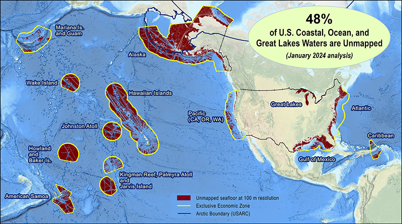
Percent of U.S. waters that remain unmapped as of January 2024:
- U.S. total – 48% of 3,590,600 square nautical miles (snm)
- Atlantic and Gulf of Mexico – 36% of 472,200 snm
- Great Lakes – 87% of 45,000 snm
- Caribbean – 30% of 61,500 snm
- Alaska – 63% of 1,080,300 snm
- Pacific (California, Oregon, Washington) – 17% of 239,700 snm
- Pacific Remote Islands and Hawaii – 47% of 1,691,900 snm
Multibeam and lidar surveys are the two primary sources of bathymetry needed to fill these gaps. In support of the integrated ocean and coastal mapping goal to “map once, use many times,” all of the data collected in this effort are publicly available to benefit numerous users. For the latest status on these efforts and how you can contribute, visit https://iocm.noaa.gov/seabed-2030-status.html.
One Reply to “The Interagency Working Group on Ocean and Coastal Mapping announces progress on mapping U.S. ocean, coastal, and Great Lakes waters”