 An
official website of the United States government.
Here's how you know we're official.
An
official website of the United States government.
Here's how you know we're official.
An
official website of the United States government.
Here's how you know we're official.
An
official website of the United States government.
Here's how you know we're official.
Coast Survey uses nautical charting data to produce GIS-friendly products for a world of uses outside of navigation. Find the product or service that supports your application.
NOAA's ENC Direct to GIS allows users to display, query, and download all available base editions of NOAA ENC® data in a variety of GIS/CAD formats, using web mapping service technology. Nautical chart features contained within a NOAA ENC provide a detailed representation of the U.S. coastal and marine environment. The data, updated weekly, is organized using S-57 object classes. Features in a single NOAA ENC are limited in that they only represent the geographic region that is depicted in that particular NOAA ENC cell. By aggregating nautical features from all NOAA ENC in the creation of GIS data, a continuous depiction of the U.S. coastal and marine environment is achieved.
In addition, three specific theme layers can be viewed or obtained for the entire United States. These standardized data sets are based on several Federal Geographic Data Committee (FGDC) and Open Geospatial Consortium (OGC) standards.
ENC Direct to GIS DOES NOT meet USCG chart carriage requirements for commercial vessels.
ENC Data Portrayed Two Different Ways
Two ENC display services provide simple HTTP interfaces for user applications to request geo-registered nautical chart images from NOAA databases for display in online and offline applications for which a basemap of nautical chart data is desired, including GIS, web-based, and mobile mapping applications.
The chart images are rendered from the latest NOAA electronic navigational chart (NOAA ENC®) data. The ENC data and the chart images derived from it are updated weekly. Each display service portrays the ENC data with a different symbology set.
The ECDIS Display Service uses symbology developed by the International Hydrographic Organization (IHO) for the display of ENC data on Electronic Chart Display and Information Systems (ECDIS) that large ocean- going vessels and many smaller commercial ships use for navigation. This symbol set is commonly referred to by its IHO specification number, "S-52," or as "ECDIS symbology."
The ENC Viewer portrays ENC data using this ECDIS symbology.
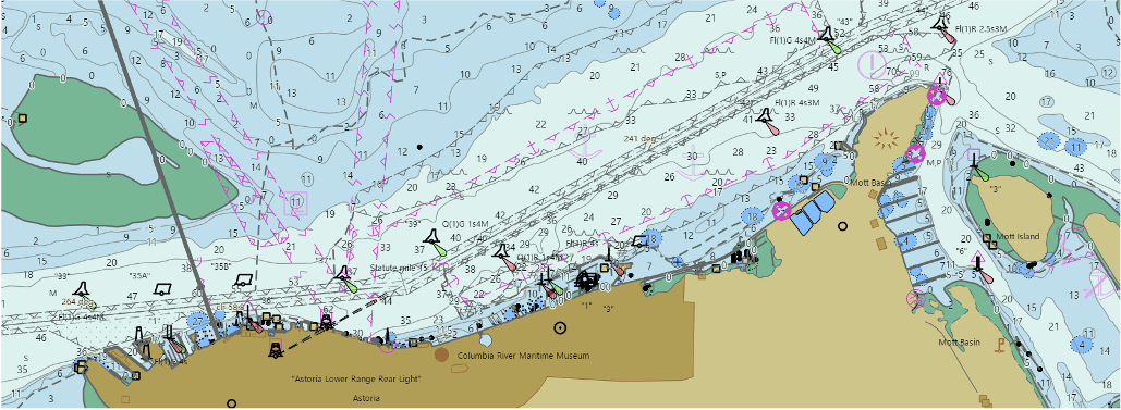 ECDIS Display Service rendering of ENC along the Columbia River with symbology specified by the IHO.
The ECDIS Display Service is available in two formats:
Esri
REST Service
OGC
Web Map Service (WMS)
The NOAA Chart Display Service renders NOAA ENC data with "traditional paper chart" symbols, labels, and color schemes familiar to those who have used NOAA paper nautical charts or the NOAA Custom Chart application.
The NOAA Chart Display Viewer Prototype portrays ENC data using this traditional symbology.
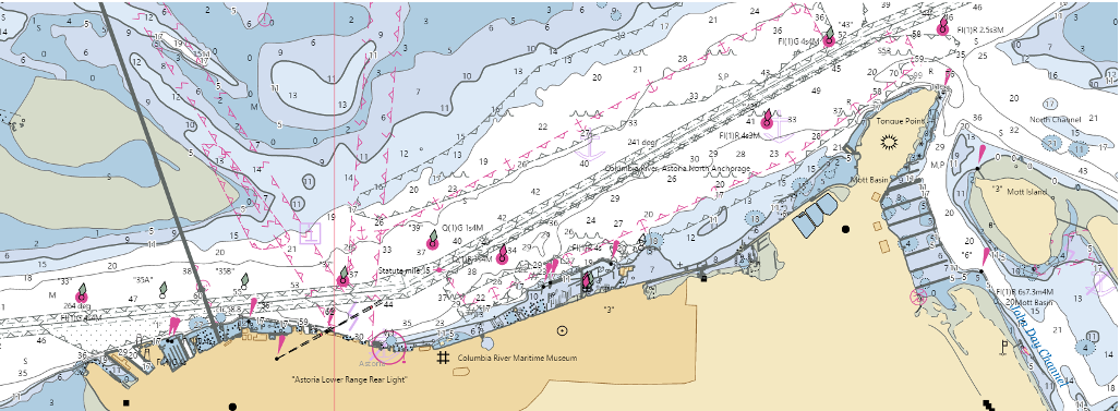 NOAA Chart Display Service rendering of ENC data along the Columbia River with traditional paper chart symbology.
The NOAA Chart Display Service is available in three formats:
Esri REST Service
OGC Web Map Service (WMS)
Web Map Tile Service (WMTS)
There is also a NOAA Chart Display Service Mapbox Tiles (MBTiles) format for offline applications.
Offline maps are useful for applications where users expect to travel through areas with limited data connectivity or who want to save on mobile roaming charges while traveling abroad. MBTiles files are SQLite databases containing tiles and metadata tables for storing tilesets. More information about the MBTiles specification is at GitHub.
To download ENC-based offline tiles, visit the NOAA Chart Display Service MBTile Download site, select a region, select the MBTiles link, and save the MBTiles file to your computer.
The NOAA Precision Marine Navigation Data Gateway Viewer shows examples of both the ECDIS Display Service and the NOAA Chart Display Service.
Coast Survey provides a set of six IENC overlay files for the Gulf Coast oil and gas lease blocks. The overlays provide coverage that extends beyond the traditional lease block charts and includes all oil and gas lease blocks within the Gulf Coast. The overlays are compiled in the inland electronic navigational chart(IENC) format and require users to have an electronic chart display and information system (ECDIS) or electronic chart system (ECS) that can ingest and display this specific format.
The lease block overlays were created from the Bureau of Ocean Energy Management geographic mapping data (BOEM). The overlays do not constitute the legal boundaries of the official lease blocks and are for situational awareness only. The authoritative Gulf Coast oil and gas lease block boundaries are in BOEM's appropriate leasing map or official protraction diagram.