HISTORY OF THE MARITIME ZONES UNDER INTERNATIONAL LAW
FROM THE CANNON SHOT RULE TO UNCLOS
For hundreds of years, the marine environment was free from regulation
of fishing, shipping, and resource exploitation. Over time, coastal
States (countries) had an increased interest in national security and
the enforcement of laws to protect its commerce and marine resources.
As a result, a balance was needed to maintain the freedom of
navigation that many foreign maritime interests had relied upon. This
need for balance is captured in the history of the law of the sea.
The birth of a nation's authority to control its coastal waters has
been traced back to the sixteenth century. In the seventeenth century,
the father of international law and doctrine on the freedom of the
seas, Grotius, recognized the existence of a nation's jurisdiction
over the coastal waters that could be effectively controlled from the
land. The extent to which a nation could control its coastal waters
was largely based on the reach of its cannons on the shore. Thus, the
3 nautical mile (nm) limit of the territorial sea resulted from what
is often referred to as the "cannon shot" rule. In the U.S., the
creation of a territorial sea and contiguous zone date back to as
early as the late 1700s in response to issues of national security and
law enforcement at coastal areas, including a 1793 diplomatic note
sent from Thomas Jefferson and legislation passed by Congress in 1799
to allow the boarding of foreign flag vessels within 12 nm from the
coast. This zone was known as "customs waters" and was later called
the "Contiguous Zone." By 1930 the proprietary rights of the coastal
state over the resources of the territorial sea was well established,
provided it did not interfere with a vessel's right of innocent
passage. In 1945, President Truman issued a proclamation asserting
rights to explore and exploit the oil and gas resources of the
continental shelf outside of the 3 nm territorial sea. In 1953, the
U.S. Congress enacted legislation over the federal and state control
of the continental shelf. In 1958, international conventions were
concluded in Geneva on the territorial sea, contiguous zone and
continental shelf. The concept of a fishery conservation zone was born
in another Truman Proclamation but Congress did not enact laws
regarding a 200 nm fishery conservation zone until 1976. This evolved
into a zone whereby a coastal nation had exclusive control over all
economic exploration and exploitation of the natural resources off its
coast. By 1982, the custom of asserting a 12 nm territorial sea, 24 nm
contiguous zone, and 200 nm EEZ was codified in the United Nations
Convention on the Law of the Sea (UNCLOS).
U.S. CONTROL IN MARITIME ZONES VS RIGHTS OF FOREIGN STATES
The U.S. proclaimed a 12 nm territorial sea in 1988, a 24 nm
contiguous zone in 1999, and a 200 nm EEZ in 1983, consistent with
customary international law as codified in UNCLOS. This customary law
is a balanced compromise between a flag State's interest in maritime
shipping and a coastal State's interest in protecting and managing its
coastal waters. The U.S. sovereignty over its terrestrial lands
extends to its internal waters and territorial sea, including the
airspace above and the seabed below. Subject to ancient customs where
nations should provide safe harbor to ships in danger or distress
(force majure), the U.S. may restrict entry or travel through its
internal waters. The U.S. may also prohibit the entry into portions of
the territorial sea, provided there is still an area that allows for
vessels to exercise their right of innocent passage through the
territorial sea. "Passage" through the territorial sea must be
continuous and expeditious, although that may include stopping and
anchoring under certain circumstances. While warships are generally
immune from laws and regulations, the U.S. has the right to require
foreign warships comply with U.S. laws. If they don't, the U.S. may
order the foreign warship to leave its territorial sea.
The contiguous zone is a buffer to the territorial sea, and within it,
the U.S. may exercise the control necessary to prevent infringement of
its customs, fiscal, immigration or sanitary laws and regulation of
territorial sea. In addition, the U.S. may regulate the removal of
cultural heritage, including foreign flagged vessels and nationals in
its contiguous zone. It overlaps the EEZ which extends from the
territorial sea out to 200 nm. The U.S. does not exercise sovereignty
in the contiguous zone or the EEZ. It does have exclusive sovereign
rights and jurisdicton for exploration and exploitation of natural
resources of the seabed, subsoil, water column, and air space in the
EEZ.
All of these zones have a common point of reference from which they
are measured: the baseline. The rules for determining the baseline
under UNCLOS are substantively the same as those under the 1958
Convention, which the U.S. ratified in 1961. As a line that marks the
inner limit of the territorial sea and the outer limit of internal
waters, the baseline is comprised of the low water line on NOAA charts
plus closing lines across legally-defined bays and rivers. The U.S.
uses a normal baseline, as opposed to a straight baseline because of
its interests in preserving the freedom of navigation. One of the most
important facts for those relying on NOAA's charts for the limits of
these zones is that the baseline and all of the zones are ambulatory.
They are subject to change due to accretion and erosion of the shore.
 An
official website of the United States government.
Here's how you know we're official.
An
official website of the United States government.
Here's how you know we're official.
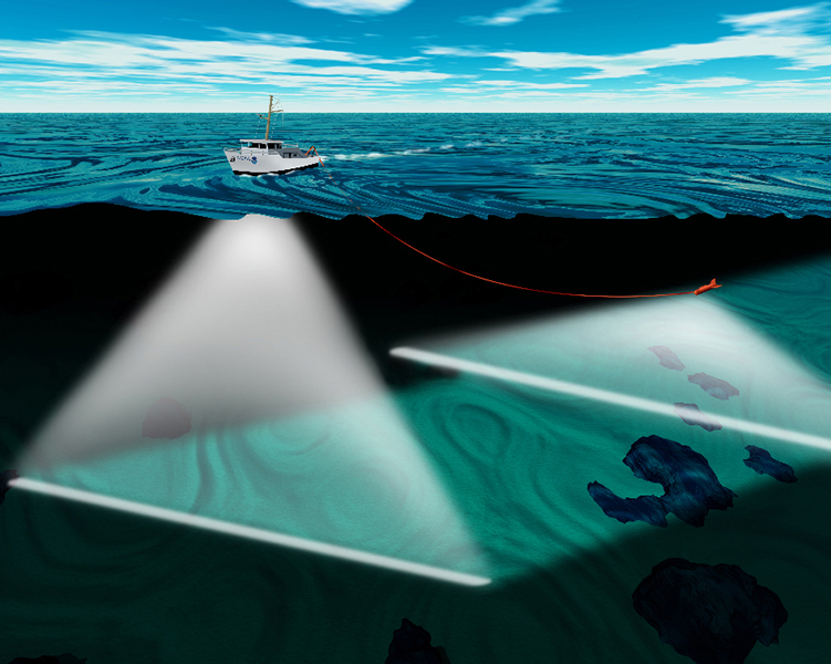 Hydrographic survey vessels utilize both a multibeam sonar and towed
side scan sonar to map the sea floor.
Hydrographic survey vessels utilize both a multibeam sonar and towed
side scan sonar to map the sea floor.
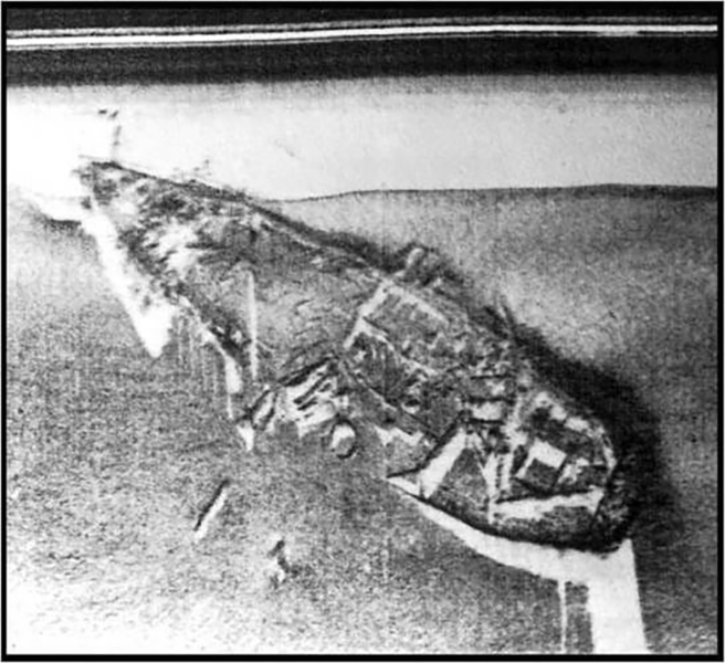 Side scan imagery helps find and identify features on the seafloor,
like this underwater wreck.
Side scan imagery helps find and identify features on the seafloor,
like this underwater wreck.