 An
official website of the United States government.
Here's how you know we're official.
An
official website of the United States government.
Here's how you know we're official.
An
official website of the United States government.
Here's how you know we're official.
An
official website of the United States government.
Here's how you know we're official.
External Source Data
NOAA's Office of Coast Survey defines external source data as data that may have value for NOAA navigation product improvements but was not originally requested by, produced intentionally for, or contracted by the National Ocean Service for the purpose of updating NOAA nautical charts. Coast Survey increasingly relies on providers to contribute data to supplement our own hydrographic survey data collection. External source data providers range from other NOAA Line Offices, to regional and state initiatives, universities, private sector surveyors, port authorities, and beyond.
All external source data that are shared with the Office of Coast Survey feeds the National Bathymetric Source Program, a part of our effort to modernize our nautical charting process. This in turn supports updates to:
The External Source Data program within the Office of Coast Survey primarily deals with bathymetry data, but also accepts other types of hydrographic data such as shoreline positions, locations of features or objects, etc. If you'd like to submit data to the Office of Coast Survey but aren't sure where to start, use our customer outreach tool, ASSIST, to get a conversation started.
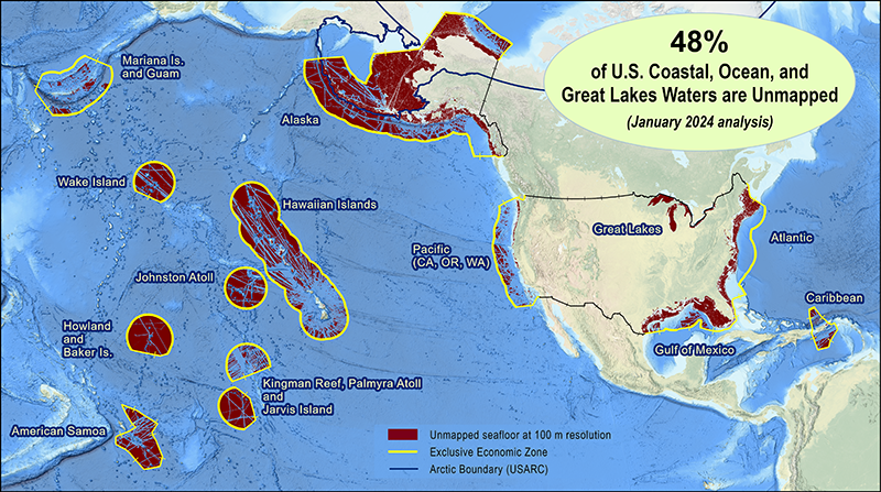
The Office of Coast Survey is interested in coastal, ocean, and Great Lakes bathymetry data collected within the United States Exclusive Economic Zone. In terms of methods used, the External Source Data program accepts data collected using a variety of systems such as multibeam, single or vertical beam, lidar, or satellite derived.
Bathymetry can be measured using various techniques and methods that lead to results with varying degrees of data quality. To define quality, Coast Survey requires specific pieces of supporting information, or metadata, to enable review of all submitted bathymetry data. Metadata gives more context to the bathymetric data that the External Source Data program receives. It provides descriptors that allow the External Source Data team to determine the data's origin, collection time, data type, type of coverage achieved, object detection capabilities, and the uncertainty of bathymetric data provided.
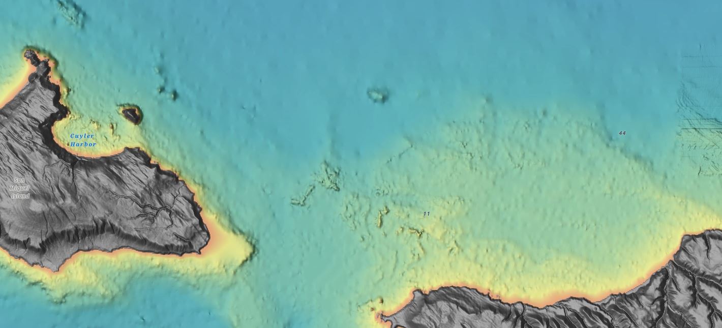 An image showing
collected bathymetric data surrounding
San Miguel
An image showing
collected bathymetric data surrounding
San MiguelMetadata associated with external source data submissions must meet our minimum metadata requirements, which align with international hydrographic standards.
Minimum metadata includes:
Thinking of external source data submissions as a box of chocolates, consider bathymetry data the chocolates within the box which contain the position and depth or the measured bathymetry. The metadata is the chocolate guide that explains the different types of chocolates in the box. Metadata includes all minimum metadata listed above, and ideally also includes additional information about the system used to acquire the bathymetry data, descriptions of acquisition and data processing methods, and the uncertainty associated with the bathymetry data provided. Both data and accurate metadata are necessary to enable complete assessment of all external source data received to enable accurate preparation for incorporation into the National Bathymetry. As you have likely experienced, the only thing worse than not having the chocolate guide is when the chocolate guide doesn't have the correct information about the chocolates and you eat a different chocolate than you were expecting.
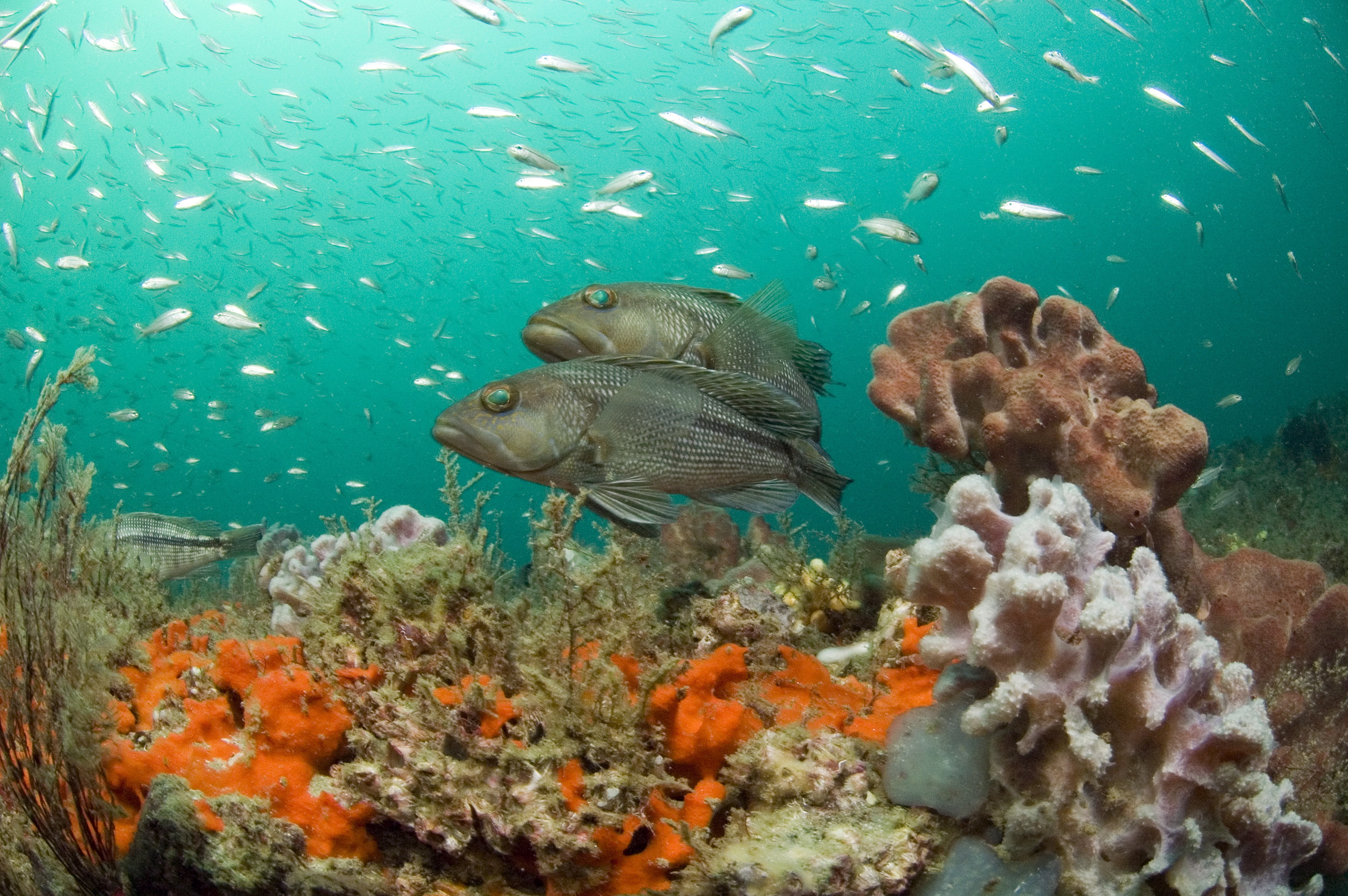
 How deep is the seafloor?
What can be seen?
How deep is the seafloor?
What can be seen?
Upon submission to the Office of Coast Survey, all external source data must be assigned a data license. All external source data submitted to the Office of Coast Survey will be handled according to the license assigned.
To get started with a data submission, please use our customer outreach tool, ASSIST or send an email to the External Source Data team to get a conversation started at esd.team@noaa.gov.
The most important thing to consider when submitting data is verifying that at least minimum metadata is included with your submission—the more supporting information, the better! We commonly receive survey reports that describe acquisition, processing, and systems used. If you have already written a report describing your data collection, we welcome that as a part of your external source data submission to aid our quality assessment process.
Metadata plays an integral role in the assessment of external source data in the Office of Coast Survey. While minimum metadata is the only requirement, any additional information describing data acquisition and processing is helpful and encouraged for submission. The latest Hydrographic Surveys Specifications and Deliverables document can serve as a useful resource to inform data submissions, as it defines all accepted data types, formats, and discusses in more detail the quality metrics that are assessed during data qualification. Aside from inclusion of minimum metadata with your data package, following the HSSD is not required, but can provide a target for deliverable formats for submission to the Office of Coast Survey.
The Office of Coast Survey welcomes data from various entities, including but not limited to, other NOAA line offices, other federal agencies, universities, state/regional initiatives, and the private sector. We accept data collected under various missions ranging from reconnaissance, to habitat mapping efforts, to wind lease area surveys, and more.
Bathymetry data accepted by the External Source Data program is typically collected using specialized ocean mapping equipment to measure the depth of the seafloor. Coast Survey is also interested in crowdsourced bathymetry, defined as depth measurements collected and contributed by vessels, using standard navigation instruments, while engaged in routine maritime operations. If you would like to submit crowdsourced bathymetry, please do so through the International Hydrographic Organization's crowdsourced bathymetry initiative hosted by the IHO Data Centre for Digital Bathymetry.
Coast Survey accepts most digital bathymetry format files including but not limited to BAGs, GeoTiffs, XYZ files, and GSFs. For additional information about reviewable file formats, please refer to the latest Hydrographic Surveys Specifications and Deliverables (HSSD).
A data license can either be listed in any supporting documentation providers send along (e.g., "Data License: CC0-1.0") OR by using the form below to facilitate the assignment of the data license. CC0-1.0 is the recommended license, allowing data use without restrictions and maximizing your data's potential impact.
All external source data is first assessed to verify that the data package is valid and includes minimum metadata. Then, each data package is evaluated and assigned standardized quality attributes that describe the coverage of the data achieved, object detection capabilities, and uncertainty of the bathymetry provided. If the data are expected to add value to Coast Survey products and services, data packages are then assigned a tracking number beginning with an "E" (e.g. E12345). Note, all data received prior to 2024 were assigned a "W" number (e.g. W12345). These tracking numbers are searchable in the National Ocean Service Hydrographic Data Archive and are discoverable in the National Centers for Environmental Information bathymetric data viewer. Finally, data are incorporated into the National Bathymetric Source program.
Charting the Nation Together
Do you have coastal, ocean, or great lakes bathymetry data within the U.S. Exclusive Economic Zone? Contact us to see if it could be included in our National Bathymetric Source program and help support ocean-going commerce and coastal economies, keep people safe and secure, and protect coastal environments.
 Habitat
Mapping
Habitat
Mapping
 Flooding Models
 Data gap analysis