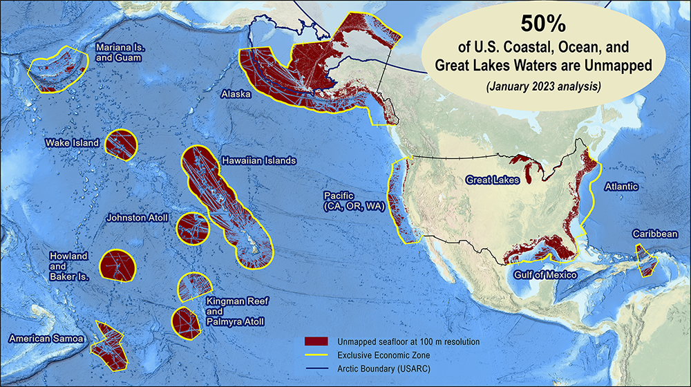
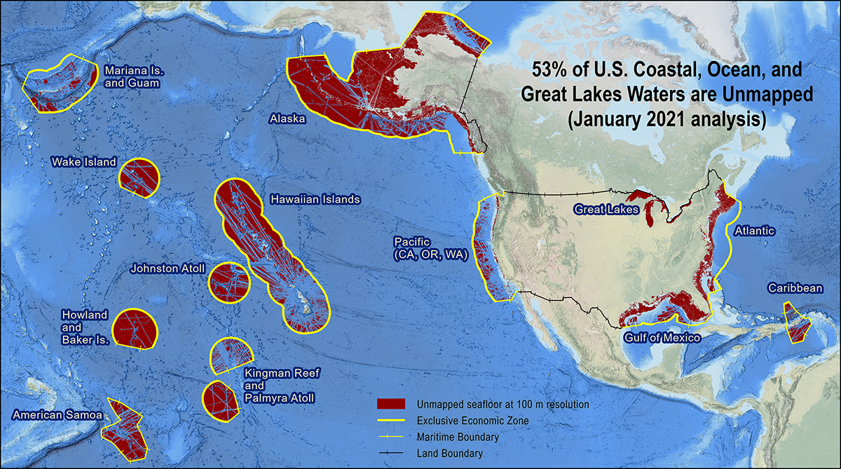
The federal Interagency Working Group on Ocean and Coastal Mapping recently released the sixth annual report on progress made in mapping U.S. ocean, coastal, and Great Lakes waters. To safeguard our national security and economic prosperity, ocean mapping, exploration, and characterization is foundational to maritime commerce, domestic energy and seafood production, tourism and recreation, and understanding of our natural resources, among other interests. The 2020 National Strategy for Mapping, Exploring, and Characterizing the United States Exclusive Economic Zone (NOMEC) makes comprehensive ocean mapping a priority for the coming decade. The Unmapped U.S. Waters report tracks progress toward these important goals.
Continue reading “The Interagency Working Group on Ocean and Coastal Mapping announces progress on mapping U.S. ocean, coastal, and Great Lakes waters”NOAA’s nowCOAST improves BlueTopo access
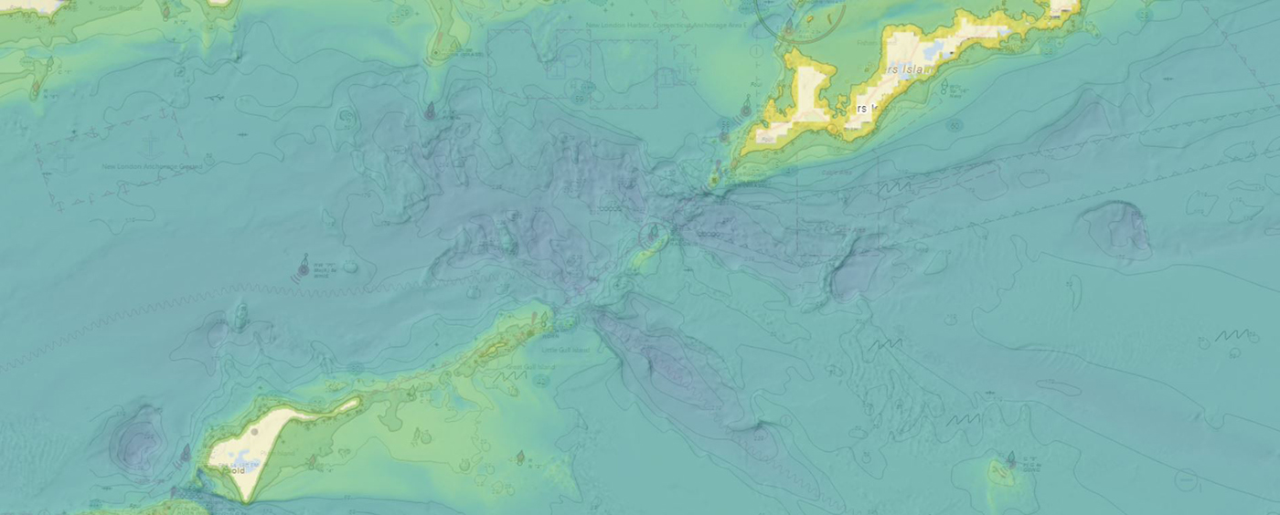
NOAA’s Office of Coast Survey produces and maintains several types of data models and products, from operational forecast systems to nautical charts. One of these models comes from the office’s National Bathymetric Source, or NBS, program which creates and maintains high-resolution bathymetry composed of the best available data. Bathymetry is a term that refers to the depths and shapes of underwater terrain and is a visualization of the “beds” or “floors” of water bodies, including the ocean, rivers, streams, and lakes. This data model is available to the public in a product called BlueTopo.
The Interagency Working Group on Ocean and Coastal Mapping announces progress on mapping U.S. ocean, coastal, and Great Lakes waters
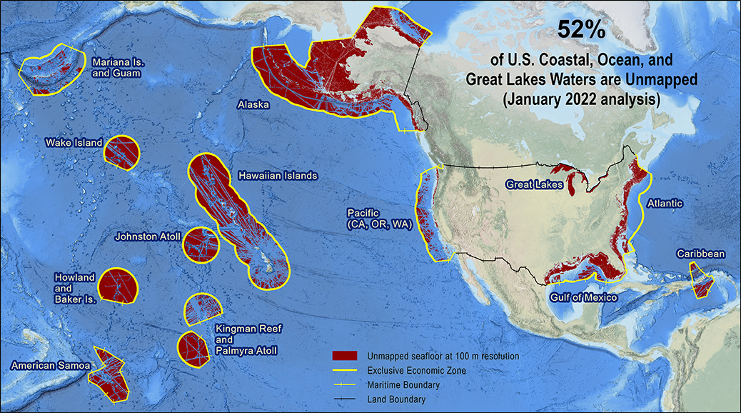
The federal Interagency Working Group on Ocean and Coastal Mapping recently released the fifth annual report on progress made in mapping U.S. ocean, coastal, and Great Lakes waters. Knowledge of the depth, shape, and composition of the seafloor has far-reaching benefits, including safer navigation, hazard mitigation for coastal resilience, preservation of marine habitats and heritage, and a deeper understanding of natural resources for sustainable ocean economies. The 2020 National Strategy for Mapping, Exploring, and Characterizing the United States Exclusive Economic Zone (NOMEC) makes comprehensive ocean mapping a priority for the coming decade. The Unmapped U.S. Waters report tracks progress toward these important goals.
Continue reading “The Interagency Working Group on Ocean and Coastal Mapping announces progress on mapping U.S. ocean, coastal, and Great Lakes waters”NOAA’s updated hydrographic survey specifications now available for public comment
A draft of the new Hydrographic Survey Specifications and Deliverables document from NOAA’s Office of Coast Survey is now posted to the Federal Register, where it will be available for public comment until October 12, 2023. All interested parties are encouraged to review the draft and provide feedback via the instructions provided in the Federal Register Notice.
Continue reading “NOAA’s updated hydrographic survey specifications now available for public comment”The Interagency Working Group on Ocean and Coastal Mapping announces progress report on mapping U.S. ocean, coastal, and Great Lakes waters
The federal Interagency Working Group on Ocean and Coastal Mapping (IWG-OCM) has released the fourth annual report on progress made in mapping U.S. ocean, coastal, and Great Lakes waters. Knowledge of the depth, shape, and composition of the seafloor has far-reaching benefits, including safer navigation, hazard mitigation for coastal resilience, preservation of marine habitats and heritage, and a deeper understanding of natural resources for sustainable ocean economies. The 2020 National Strategy for Mapping, Exploring, and Characterizing the United States Exclusive Economic Zone (NOMEC) and the Nippon Foundation-GEBCO Seabed 2030 Project make comprehensive ocean mapping a priority for the coming decade. The Unmapped U.S. Waters report tracks progress toward these important goals.
Continue reading “The Interagency Working Group on Ocean and Coastal Mapping announces progress report on mapping U.S. ocean, coastal, and Great Lakes waters”The Interagency Working Group on Ocean and Coastal Mapping announces progress report on mapping U.S. ocean, coastal, and Great Lakes waters
The Interagency Working Group on Ocean and Coastal Mapping (IWG-OCM) has released the third annual report on the progress made in mapping U.S. ocean, coastal, and Great Lakes waters. Knowledge of the depth, shape, and composition of the seafloor has far-reaching benefits, including safer navigation, hazard mitigation for coastal resilience, preservation of marine habitats and heritage, and a deeper understanding of natural resources for sustainable ocean economies. The 2020 National Strategy for Mapping, Exploring, and Characterizing the United States Exclusive Economic Zone and the global Seabed 2030 initiative make comprehensive ocean mapping a priority for the coming decade. The Unmapped U.S. Waters report tracks progress toward these important goals.
The Interagency Working Group on Ocean and Coastal Mapping announces progress report on mapping U.S. ocean, coastal, and Great Lakes waters
The Interagency Working Group on Ocean and Coastal Mapping (IWG-OCM) released the second annual report on the progress made in mapping U.S. ocean, coastal, and Great Lakes waters. The depth, shape, and composition of the seafloor are foundational data elements that we need to understand in order to explore, sustainably develop, conserve, and manage our coastal and offshore ocean resources. The 2020 National Strategy for Mapping, Exploring, and Characterizing the United States Exclusive Economic Zone and the global Seabed 2030 initiative make comprehensive ocean mapping a priority for the coming decade. The Unmapped U.S. Waters report tracks progress toward these important goals.
Continue reading “The Interagency Working Group on Ocean and Coastal Mapping announces progress report on mapping U.S. ocean, coastal, and Great Lakes waters”NOAA Coast Survey’s new strategy supports charting mandates and broader seafloor mapping
This week, NOAA’s Office of Coast Survey released the Mapping U.S. Marine and Great Lakes Waters: Office of Coast Survey Contributions to a National Ocean Mapping Strategy. This report is part of NOAA’s ongoing commitment to meet core surveying and nautical charting mandates while supporting broader needs to fill gaps in seafloor mapping and environmental sciences.
Continue reading “NOAA Coast Survey’s new strategy supports charting mandates and broader seafloor mapping”NOAA announces new progress report on mapping U.S. ocean, coastal, and Great Lakes waters
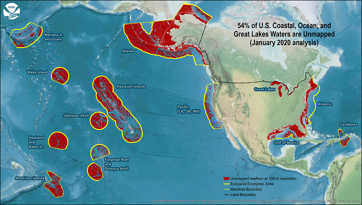
NOAA released the first annual report on the progress made in mapping U.S. ocean, coastal, and Great Lakes waters. The depth, shape, and composition of the seafloor are foundational data elements that we need to understand in order to explore, sustainably develop, conserve, and manage our coastal and offshore ocean resources. The 2019 Presidential Memorandum on Ocean Mapping of the United States Exclusive Economic Zone and the Shoreline and Nearshore of Alaska and the global Seabed 2030 initiative make comprehensive ocean mapping a priority for the coming decade. The Unmapped U.S. Waters report tracks progress toward these important goals.
Continue reading “NOAA announces new progress report on mapping U.S. ocean, coastal, and Great Lakes waters”Building the National Bathymetry
By Katrina Wyllie and Glen Rice
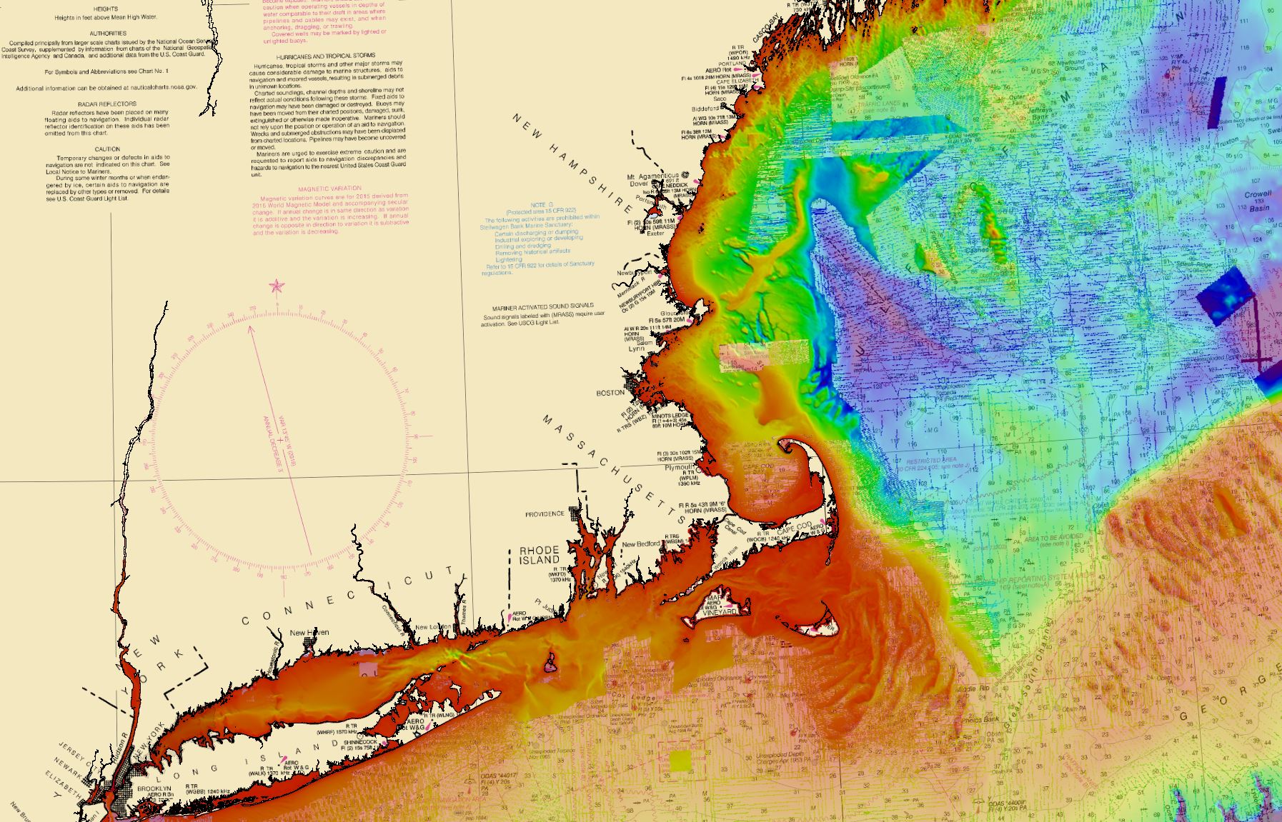
The National Bathymetric Source (NBS) project creates and maintains high-resolution bathymetry composed of the best available data. This project enables the creation of next-generation nautical charts while also providing support for modeling, industry, science, regulation, and public curiosity.
Continue reading “Building the National Bathymetry”
