
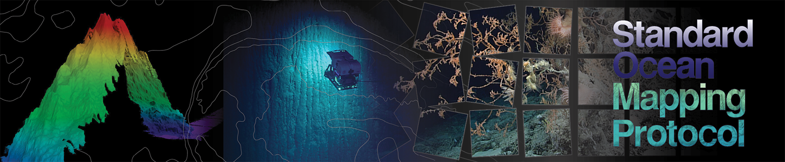
The members of the federal Interagency Working Group on Ocean and Coastal Mapping (IWG-OCM) are thrilled to announce the release of the first Standard Ocean Mapping Protocol (SOMP)! The SOMP is a standardized technical protocol for acquisition, processing, and archiving of ocean and coastal mapping data. It was developed in support of National Strategy for Ocean Mapping, Exploring, and Characterizing the United States Exclusive Economic Zone (NOMEC) goals and is built from existing standards and best practices developed by the ocean and coastal mapping community.
In his April 2024 comments on the release of the 5th annual bathymetric mapping progress report, Rear Admiral Benjamin Evans, director of NOAA’s Office of Coast Survey, noted that we are making …”continued progress toward mapping all U.S. waters to modern standards… However, at the current rate of participation, we are only meeting about one-third of our annual NOMEC mapping goal. Each year that passes without full mapping of U.S. waters elevates risk, increases costs, and surrenders economic benefit for the U.S. economy. To address this deficiency, we must encourage the development of more regional campaigns that instill the values of data sharing and coordinated acquisition, as well as serve as a platform to increase partnerships that leverage contributions of new and existing data from non-traditional mapping sectors.”
Facilitating those contributions is the key objective of the protocol—to improve consistency in how we all collect and steward ocean and coastal mapping data so that data from many sources can be shared and integrated. The SOMP is intended to enable the widest access to, use of, and integration of data, while minimizing duplication of effort. It also maximizes the efficient collection, processing, publishing, and stewardship of ocean and coastal mapping data to move as much data as possible into publicly accessible archives, repositories, and databases to meet user needs and NOMEC goals.
Following are brief overviews of the featured chapters.
Introduction
Pursuant to Objective 2.1 of the Strategy and Implementation Plan in the National Strategy for Mapping, Exploring, and Characterizing the United States Exclusive Economic Zone, this document is a standardized technical protocol for acquisition, processing, and archiving of ocean and coastal mapping data. The goals of the document are to facilitate the widest access to, use of, and integration of data; minimize duplication of effort; and maximize the efficient collection, processing, publishing, and stewardship of as much ocean and coastal mapping data as possible into publicly accessible archives, repositories, and databases. National data standards and best practices will be used, as required by the Geospatial Data Act of 2018 (Federal Geographic Data Committee, 2018).
Chapter 1: Data Management
This chapter covers methods for effective data management and stewardship, metadata records, and archive techniques, with the intent of promoting data accessibility and utility by a broad spectrum of users, including the public.
Chapter 2: Bathymetry
This chapter focuses on procedures for the collection, processing, and delivery of bathymetric data, such as that acquired by sonar systems (multibeam, single beam, phase-discriminating) and light detection and ranging (lidar) systems. This chapter summarizes best practices for system setup, calibration, and maintenance; data resolution, range, and survey coverage; positioning and spatial reference; sound speed correction; tides and water levels; quality assurance/quality control techniques, accuracy, and uncertainty; data processing and handling; and general gridded data specifications.
Chapter 3: Seabed and Lakebed Backscatter
This chapter covers standard backscatter acquisition and processing methods, acoustic signal corrections, and image processing steps. This chapter describes backscatter, its existing challenges in data usage, protocols to apply, and information that should be documented during surveying and processing. The chapter advocates the Marine Geological and Biological Habitat Mapping Backscatter Working Group publication Backscatter Measurements by Seafloor-Mapping Sonar: Guidelines and Recommendations (Lurton and Lamarche, 2015) as best practices.
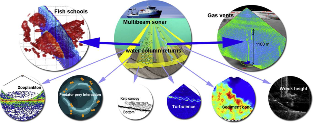
Chapter 4: Water Column Sonar
This chapter focuses on the collection, processing, and delivery of raw and interpreted backscatter from single beam and multibeam echosounders. This chapter summarizes best practices for system configuration and calibration; operating frequencies and depth ranges; quality assurance/quality control techniques; analysis and interpretation of backscatter and derived products; and file formats.
Chapter 5: Side Scan Sonar
This chapter concentrates on the collection, processing, and delivery of side scan sonar data. This chapter summarizes best practices for system configuration and calibration; general data acquisition parameters (e.g., range scales, frequencies, ping rates, survey speed); data resolution and survey coverage; positioning and spatial reference; target detection; quality assurance/quality control techniques, accuracy, and uncertainty; and data processing, mosaic generation, and derivation of products.
Chapter 6: Sub-bottom Profiling
This chapter covers common system types and describes the standard operating procedure for the use of single-channel acoustic systems that commonly operate in the 0.2 to 24 kilohertz frequency range to remotely image seafloor surface morphology and near-surface stratigraphy. Topics include practical survey design; conventional acquisition procedures and parameters; data resolution; quality assurance/quality control techniques; processing protocols; data formats; and publication of sub-surface imaging data.
Chapter 7: Magnetometry
This chapter focuses on general magnetic theory as it relates to anomaly detectability; factors that influence data quality; instrument selection, configuration, testing, and calibration; data sensitivity and coverage specifications; resolution/line spacing based on survey objectives; and data validation.
The IWG-OCM writing team will formally update and create a new version of the protocol every five years to take advantage of innovative new technologies and best practices as they arise. However, the SOMP is intended to be a living document so comments and feedback to improve it are always welcome at iwgocm.staff@noaa.gov. For the latest on these efforts and how you can contribute, visit https://iocm.noaa.gov/standards/standard-ocean-mapping-protocol.html.