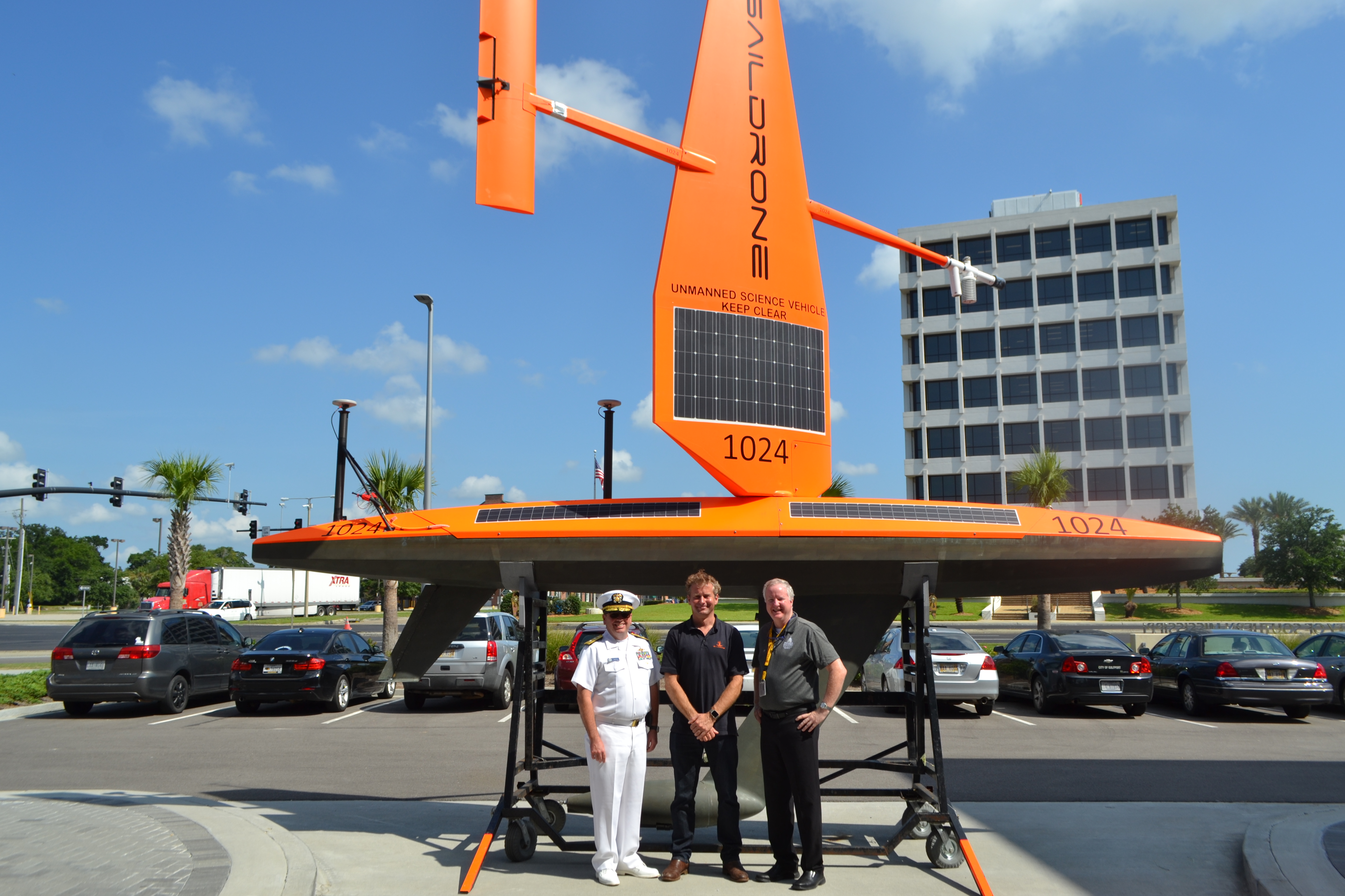
NOAA’s Office of Coast Survey, the University of Southern Mississippi (USM), and Saildrone accomplished a key milestone in the research and testing of unmanned technology that can lead to enhanced seafloor mapping capabilities with the launch of the first Saildrone — a wind-driven and solar-powered unmanned surface vehicle (USV) — equipped with multibeam echo sounder technology in the Gulf of Mexico. NOAA anticipates the success of this mission and technical achievement will lead to mapping projects in the Arctic.
Continue reading “Saildrone launched with seafloor mapping capabilities in the Gulf of Mexico shows promise for remote Arctic mapping”NOAA hosts 2019 Nautical Cartography Open House and Chart Adequacy Workshop
Last week, NOAA’s Office of Coast Survey held its third annual Nautical Cartography Open House welcoming over 250 attendees from the U.S. and abroad. Government agencies, industry and academic partners, and members of the public attended. The open house featured posters, presentations, tours, and exhibits centered around four themes: Bathymetric Databases, Custom Charting, Innovative Cartography, and Precision Navigation. Dr. Shachak Pe’eri, organizer of the event and chief of the Cartographic Support Branch in the Marine Chart Division, welcomed attendees in the morning and John Nyberg, chief of the Marine Chart Division, gave the keynote speech.
Continue reading “NOAA hosts 2019 Nautical Cartography Open House and Chart Adequacy Workshop”NOAA releases new navigational chart viewers
On July 20, 2019, NOAA’s Office of Coast Survey unveiled two new GIS viewers — NOAA ENC® viewer and NOAA RNC® viewer — allowing users to seamlessly interact with NOAA’s various chart products.
Continue reading “NOAA releases new navigational chart viewers”Coast Survey spotlight: Meet Kurt Mueller
Ever wonder what it’s like to be a member of the NOAA Coast Survey team? We use the Coast Survey spotlight blog series as a way to periodically share the experiences of Coast Survey employees as they discuss their work, background, and advice.
Kurt Mueller, physical scientist
Continue reading “Coast Survey spotlight: Meet Kurt Mueller”“The hydrographic data we acquire and review adds to the scientific knowledge of the seafloor and is valuable to other agencies to simulate sea level effects on coasts, identify sensitive marine habitats, and select alternative energy sites, among many other uses.”
NOAA releases 2019 hydrographic survey plans
NOAA’s Office of Coast Survey is the nation’s nautical chartmaker, and maintains a suite of more than a thousand nautical charts. Coast Survey is responsible for charting U.S. waters and Great Lakes covering 3.4 million square nautical miles (SNM) of water and 95,000 miles of coastline.
NOAA’s hydrographic survey ships along with hydrographic contractor vessels, recently kicked off the 2019 hydrographic survey season. These surveys not only update the suite of nautical charts, but also help to maintain the safety of maritime commerce, recreational boaters, natural ecosystems, and much more. Operations are scheduled for maritime priority areas around the country and are outlined in Coast Survey’s “living” story map. Here is a list of where they are headed this year:
Continue reading “NOAA releases 2019 hydrographic survey plans”NOAA releases new edition of nautical chart symbol guide
Edition 13 of U.S. Chart No. 1 is now available to download for free on Coast Survey’s website. Paper copies may also be purchased from any of four NOAA Chart No. 1 publishing agents.
This 130-page book describes the symbols, abbreviations, and terms used on paper NOAA nautical charts and for displaying NOAA electronic navigational chart (NOAA ENC®) data on Electronic Chart Display and Information Systems (ECDIS). The document also shows paper chart symbols used by the National Geospatial-Intelligence Agency and symbols specified by the International Hydrographic Organization.
Continue reading “NOAA releases new edition of nautical chart symbol guide”NOAA encourages all mariners to use NOAA ENC® for latest updates and other advantages
NOAA’s Office of Coast Survey maintains a suite of over 1,000 NOAA electronic navigational charts (ENC) and paper nautical charts, and like many other chart producing nations, maintains an ENC focused production process called “ENC-first.” That is, ENCs are the “first” or primary nautical product, and new data is compiled onto ENCs before all other products.
Continue reading “NOAA encourages all mariners to use NOAA ENC® for latest updates and other advantages”Change of command for NOAA Ship Thomas Jefferson
On April 12, 2019, the crew of NOAA Ship Thomas Jefferson hosted a change of command in Brooklyn, NY. Cmdr. Briana Welton Hillstrom accepted command of Thomas Jefferson, relieving Capt. Christiaan van Westendorp in a ceremony led by Capt. David Zezula, commanding officer of NOAA’s Office of Marine and Aviation Operations (OMAO) Marine Operations Center-Atlantic.
Continue reading “Change of command for NOAA Ship Thomas Jefferson”
Coast Survey spotlight: Meet Tim Wilkinson
Ever wonder what it’s like to be a member of the NOAA Coast Survey team? We use the Coast Survey spotlight blog series as a way to periodically share the experiences of Coast Survey employees as they discuss their work, background, and advice.
Tim Wilkinson, navigation response team member
“Our nation’s waterways are constantly changing and the technology we’re using to chart them is becoming increasingly more accurate. My position and my counterparts on the other teams are integral to developing accurate charts to ensure safer navigation. We also act as emergency responders to situations such as hurricanes and ship groundings.”
Continue reading “Coast Survey spotlight: Meet Tim Wilkinson”
U.S. Coast Pilot® now contains Navigation Rules
NOAA recently announced that all nine United States Coast Pilot® volumes now contain the U.S. Coast Guard International Regulations for the Prevention of Collisions at Sea (72 COLREGS) and the Inland Navigation Rules — commonly known as the “Rules of the Road.” The navigation rules are similar to rules on the highway as they present a consistent way to navigate safely and avoid collisions. Having the newly published Coast Pilot now fulfills the legal requirement for mariners to maintain a copy of these regulations on board.
Continue reading “U.S. Coast Pilot® now contains Navigation Rules”