NOAA navigation response team investigates hazardous shoal off Rockaway Point, NY

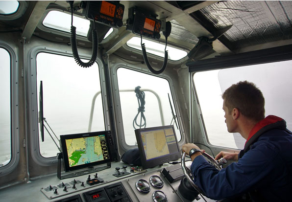
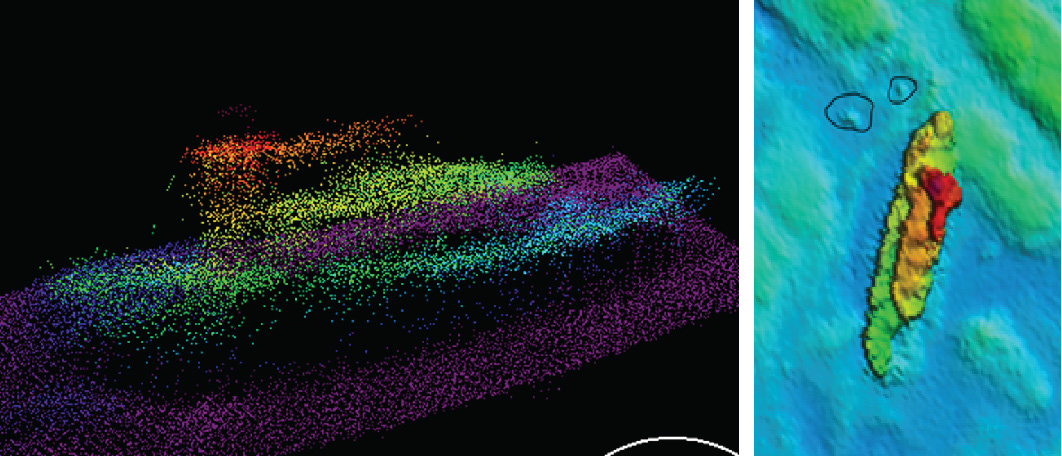
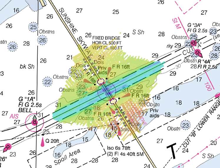
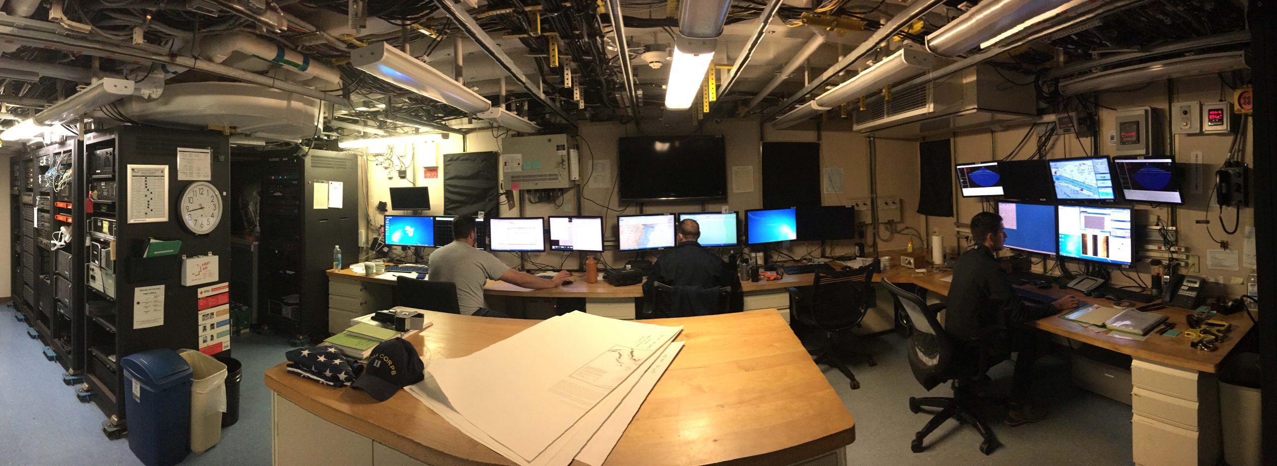
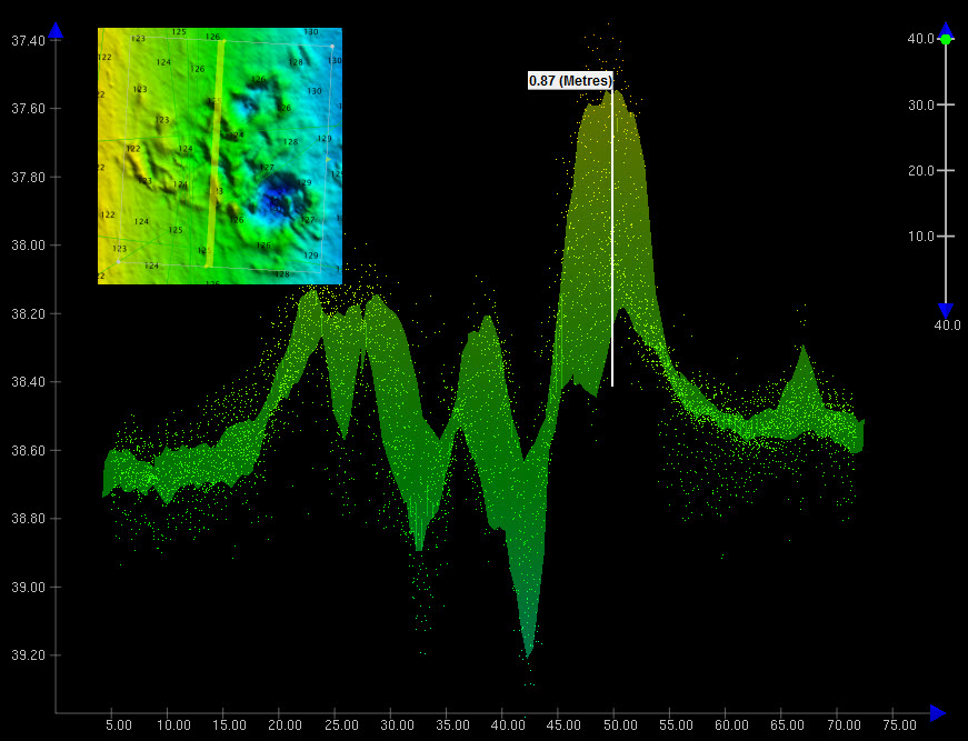
Recently, NOAA navigation response team 5 (NRT5), responded to a survey request from U.S. Coast Guard (USCG) Sector New York following several groundings near Rockaway Point in Queens, New York. Waves and currents often influence the size and shape of nearshore sandbars, and the USCG was concerned that a sandbar may have expanded beyond the area depicted on the nautical chart. Lt. j.g. Dylan Kosten, Eli Smith, and Michael Bloom traveled from New London, Connecticut, to Jersey City, New Jersey, to launch their vessel and start the survey of the area.
Continue reading “NOAA navigation response team investigates hazardous shoal off Rockaway Point, NY”

NOAA navigation response team locates sunken vessel before nor’easter strikes

Multibeam Imagery of the vessel

On March 12, 2018, NOAA Coast Survey’s navigation response team 5 (NRT5) located the T/V Captain Mackintire, an 80-foot towing vessel that sank off the coast of Kennebunkport, Maine. The U.S. Coast Guard requested assistance finding the vessel, citing concerns of environmental hazards due to an unknown amount of fuel remaining onboard.
Continue reading “NOAA navigation response team locates sunken vessel before nor’easter strikes”

NOAA surveys for recreational boat traffic safety in Tampa Bay

Multibeam echo sounder coverage. Credit: NOAA

NOAA’s navigation response team 2 (NRT2), homeported in Fernandina Beach, Florida, conducted a survey around the Sunshine Skyway Bridge, which spans Tampa Bay. The U.S. Coast Guard (USCG) and additional members of the Tampa Bay Harbor Safety Committee requested the work and expressed interest in establishing alternate routes for recreational boating traffic. Alternative routes will alleviate increasing congestion where the main ship channel passes beneath the bridge. This area is naturally restrictive to navigation and, as a result, there have been multiple accidents and near accidents here in the past. Continue reading “NOAA surveys for recreational boat traffic safety in Tampa Bay”

Surveyor Spotlight: NOAA navigation response team member, Erin Diurba

Erin Diurba, hydrographic surveyor on NOAA navigation response team 4, homeported in Galveston, Texas.

Have you ever wondered what it is like to work on a NOAA navigation response team (NRT) or what makes our team members experts in their field?
The Office of Coast Survey deploys NRTs across the country to conduct emergency hydrographic surveys requested by the U.S. Coast Guard, port officials, and other first responders in the wake of accidents and natural events that create navigation hazards. In their day‐to‐day, non‐emergency role, the NRTs work in the nation’s busiest ports, surveying for dangers to navigation and updating nautical chart products.
Meet Erin Diurba, a NOAA navigation response team member homeported in Galveston, Texas. Her self-described “survey wanderlust” has taken her across the globe to gain hydrographic surveying expertise on diverse teams and in unique environments. She tells her story here in this story map. Continue reading “Surveyor Spotlight: NOAA navigation response team member, Erin Diurba”

NOAA Office of Coast Survey wraps up a busy 2017 hurricane season

The 2017 Atlantic hurricane season was powerful, with the strongest storms occurring consecutively from late August to early October. The sequential magnitude of four hurricanes in particular—Harvey, Irma, Maria, and Nate—made response efforts challenging for NOAA’s Office of Coast Survey. Coast Survey summarized this season’s response efforts along with the efforts of NOAA Ship Thomas Jefferson (operated by NOAA’s Office of Marine and Aviation Operations) in the following story map. Continue reading “NOAA Office of Coast Survey wraps up a busy 2017 hurricane season”

NOAA travels to Puerto Rico to help ports recover from Hurricane Maria

NOAA loads the MIST kit and crew on board the USCG C-130 aircraft at Naval Air Station Jacksonville.

Hurricane Maria struck the U.S. Virgin Islands (USVI) and Puerto Rico on Wednesday, September 21, as a strong Category 4 hurricane. The storm brought sustained winds of 150 mph and dropped over 18 inches of rain in some areas. Although these islands have seen their fair share of hurricanes and tropical storms, the last storm of this intensity to hit Puerto Rico was the San Felipe Segundo hurricane in 1928. The widespread flooding, winds, and storm surge from Hurricane Maria devastated the islands leaving them without power and their critical ports paralyzed as debris, shoaling, and damaged infrastructure prevents large vessels from entering safely.
Continue reading “NOAA travels to Puerto Rico to help ports recover from Hurricane Maria”

NOAA helps ports recover in Georgia and Florida following Hurricane Irma

View of the first fuel ship entering the Port of Tampa after Hurricane Irma, as it passes NRT 5.

Just as Hurricane Harvey response was wrapping up for some of NOAA Coast Survey’s navigation response teams (NRT), personnel and survey assets were positioned in preparation for the aftermath of Hurricane Irma.   
For the NRTs, this meant traveling hundreds of miles with a survey vessel in tow, facing challenges such as locating fueling stations, finding available lodging, and finding opportunities to rest. For the mobile integrated survey team (MIST), which is available to travel anywhere in the U.S. when hydrographic survey assistance is needed by the U.S. Coast Guard (USCG) or U.S. Army Corps of Engineers (USACE), this meant finding transportation to a disaster area and a  “vessel of opportunity” to survey from once there. Continue reading “NOAA helps ports recover in Georgia and Florida following Hurricane Irma”

NOAA positions personnel and survey assets in preparation for Hurricane Irma

Projected path of Hurricane Irma as seen in nowCOAST™.

As Hurricane Irma approaches Puerto Rico as a Category 5 storm, NOAA is positioning personnel and hydrographic survey assets to help speed the resumption of shipping post storm. In the wake of a hurricane, NOAA’s personnel and survey assets provide essential information when ports need to quickly but safely re-open, limiting significant economic losses caused by prolonged disruptions to the maritime transportation system. Continue reading “NOAA positions personnel and survey assets in preparation for Hurricane Irma”

NOAA helps four ports recover from Hurricane Matthew

Matthew became a hurricane on Thursday, September 29, and it was soon clear that NOAA’s navigation services would be called into action. Coast Survey knew they would be needed for the maritime transportation system’s rapid recovery operations, to search for underwater debris and shoaling. That Saturday, while Hurricane Matthew was still three days away from hitting Haiti, Coast Survey was already ramping up preparations for assisting with reopening U.S. shipping lanes and ports after Matthew’s destruction. By Monday, as NOAA’s National Hurricane Center zeroed in on a major hit to the southeast coast, Coast Survey’s navigation service personnel began moving personnel and survey vessels for rapid deployment. Calling in survey professionals from as far away as Seattle, teams were mobilized to locations outside of the hurricane’s impact zones, so they would be ready to move in and hit the water as soon as weather and ocean conditions allowed.
Continue reading “NOAA helps four ports recover from Hurricane Matthew”

Coast Survey research vessel helps Coast Guard re-establish normal ship traffic in the Chesapeake

Coast Survey’s research vessel, Bay Hydro II, was diverted from its regular hydrographic mission this week to help the U.S. Coast Guard determine if there was a new danger to navigation in the Chesapeake Bay.
On June 13, 2016, U.S. Coast Guard Sector Hampton Roads was notified that the barge WEEKS 179 lost a large portion of its cargo near the Virginia-Maryland line, in a charted traffic scheme area that takes ships around Smith Point in the Chesapeake Bay. The WEEKS 179, carrying construction materials to New Jersey, lost approximately 25 concrete beams and bridge deck pieces, ranging from 10 ft. to 15 ft. long. While the Coast Guard diverted ship traffic around the area, Bay Hydro II deployed to the site, to establish the cargo’s exact position and determine if it posed a hazard to navigation.
By early the next morning, Bay Hydro II was conducting the search. The survey technicians used side scan sonar to locate the sunken cargo, and then followed it up with their multibeam echo sounder to collect bathymetric data over the field of debris. (While the side scan sonar is typically a better search tool for locating objects in large areas, the multibeam is best for obtaining precise position and depths over the items so the hydrographers can determine if dangers to navigation exist.)
Continue reading “Coast Survey research vessel helps Coast Guard re-establish normal ship traffic in the Chesapeake”