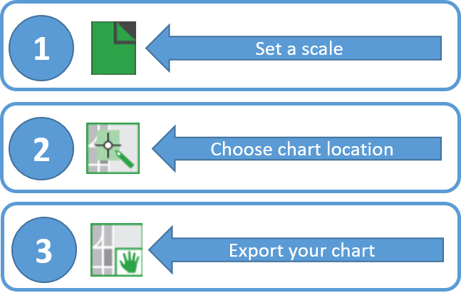
A prototype version of a powerful new online tool, NOAA Custom Chart, is now available for boaters and other nautical chart users. The application enables users to define the scale and paper size of custom-made nautical charts centered on a position of their choosing. Once the functionality of this prototype is fully developed, NOAA Custom Chart will be an easy way for boaters to create a paper or digital back-up for the electronic chart system or other GPS-enabled chart display that they are using on board. Continue reading “Online NOAA Custom Chart lets boaters create their own charts”
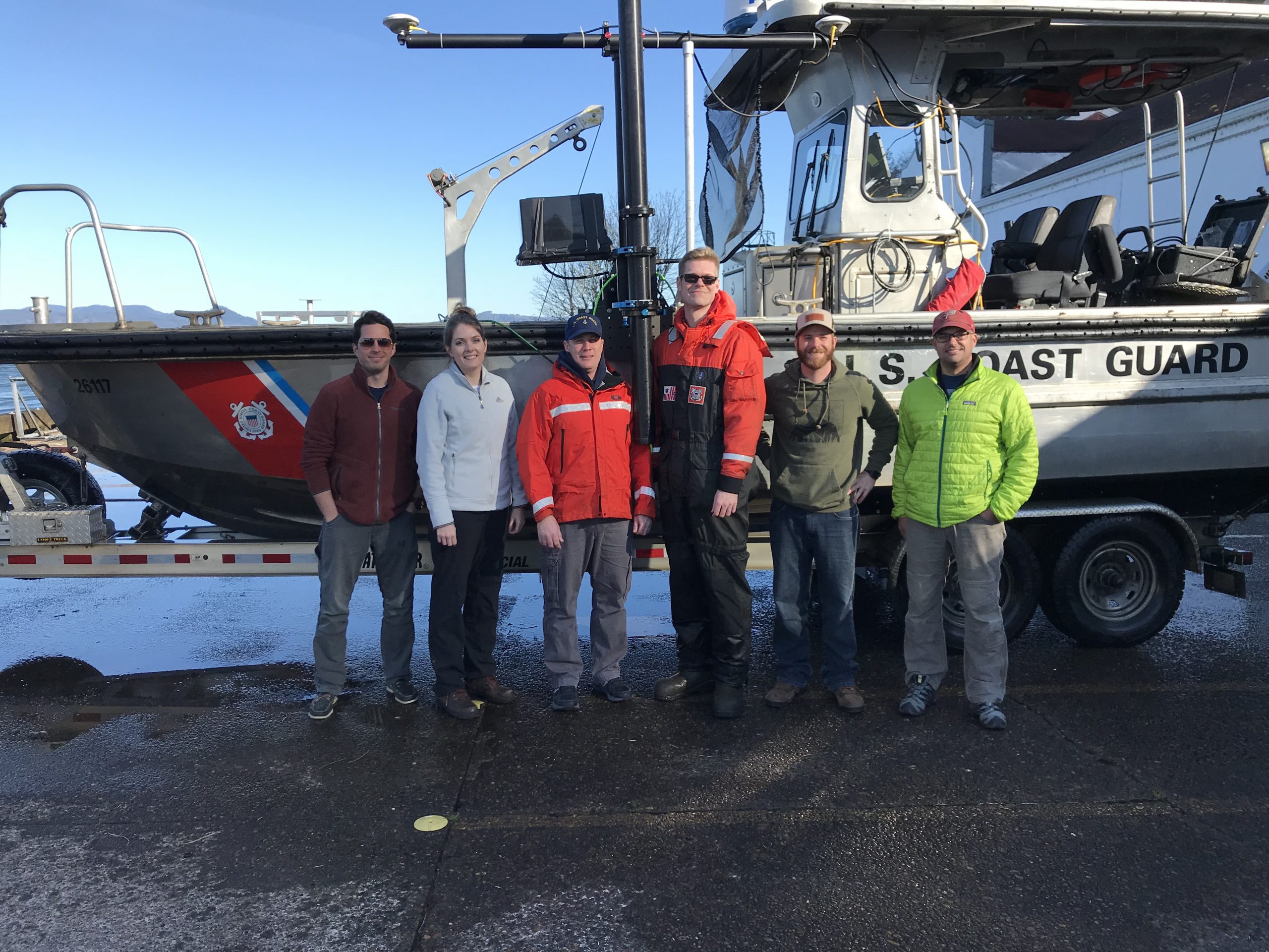
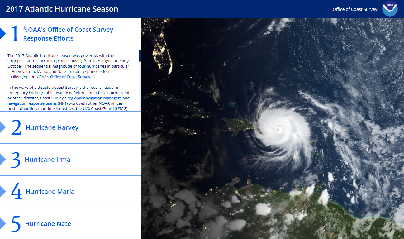
NOAA’s Office of Coast Survey is the federal leader in emergency hydrographic response. Consecutive strong storms during the 2017 hurricane season made response efforts challenging, and emphasized the importance of having a well-trained and versatile staff. Coast Survey’s regional navigation managers, navigation response teams (NRTs), and mobile integrated survey team (MIST) worked with partners before and after the storms to quickly and safely reopen ports and waterways. The MIST equipment is a mobile, quick-install side scan and single beam sonar kit that can be quickly set up on a vessel of opportunity. Recently, Coast Survey sent the MIST team to Astoria, Oregon to conduct a hydrographic survey of the Mott Basin area, which the U.S. Coast Guard (USCG) requested to confirm charted depth and obstruction data. Continue reading “NOAA mobile integrated survey team prepares for hurricane season”
Recently, NOAA navigation response team 5 (NRT5), responded to a survey request from U.S. Coast Guard (USCG) Sector New York following several groundings near Rockaway Point in Queens, New York. Waves and currents often influence the size and shape of nearshore sandbars, and the USCG was concerned that a sandbar may have expanded beyond the area depicted on the nautical chart. Lt. j.g. Dylan Kosten, Eli Smith, and Michael Bloom traveled from New London, Connecticut, to Jersey City, New Jersey, to launch their vessel and start the survey of the area. Continue reading “NOAA navigation response team investigates hazardous shoal off Rockaway Point, NY”
On March 12, 2018, NOAA Coast Survey’s navigation response team 5 (NRT5) located the T/V Captain Mackintire, an 80-foot towing vessel that sank off the coast of Kennebunkport, Maine. The U.S. Coast Guard requested assistance finding the vessel, citing concerns of environmental hazards due to an unknown amount of fuel remaining onboard.
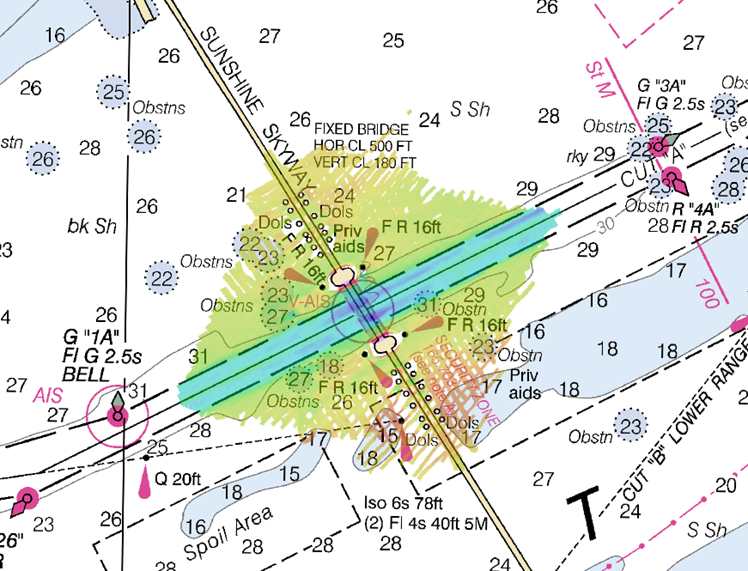
NOAA’s navigation response team 2 (NRT2), homeported in Fernandina Beach, Florida, conducted a survey around the Sunshine Skyway Bridge, which spans Tampa Bay. The U.S. Coast Guard (USCG) and additional members of the Tampa Bay Harbor Safety Committee requested the work and expressed interest in establishing alternate routes for recreational boating traffic. Alternative routes will alleviate increasing congestion where the main ship channel passes beneath the bridge. This area is naturally restrictive to navigation and, as a result, there have been multiple accidents and near accidents here in the past.
The 2017 Atlantic hurricane season was powerful, with the strongest storms occurring consecutively from late August to early October. The sequential magnitude of four hurricanes in particular—Harvey, Irma, Maria, and Nate—made response efforts challenging for NOAA’s Office of Coast Survey. Coast Survey summarized this season’s response efforts along with the efforts of NOAA Ship Thomas Jefferson (operated by NOAA’s Office of Marine and Aviation Operations) in the following story map.
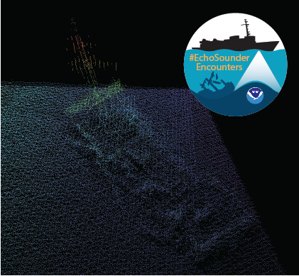
In late spring, while surveying off the coast of Long Island in Kodiak, Alaska, NOAA Ship Rainier found an uncharted shipwreck. Although rocks around the shipwreck were previously charted, this sunken vessel is a new feature. What made the find unique was how the top of wreck’s mast resembled a yellow light at the water’s surface. The Rainier crew fondly nicknamed it “ET’s finger.”
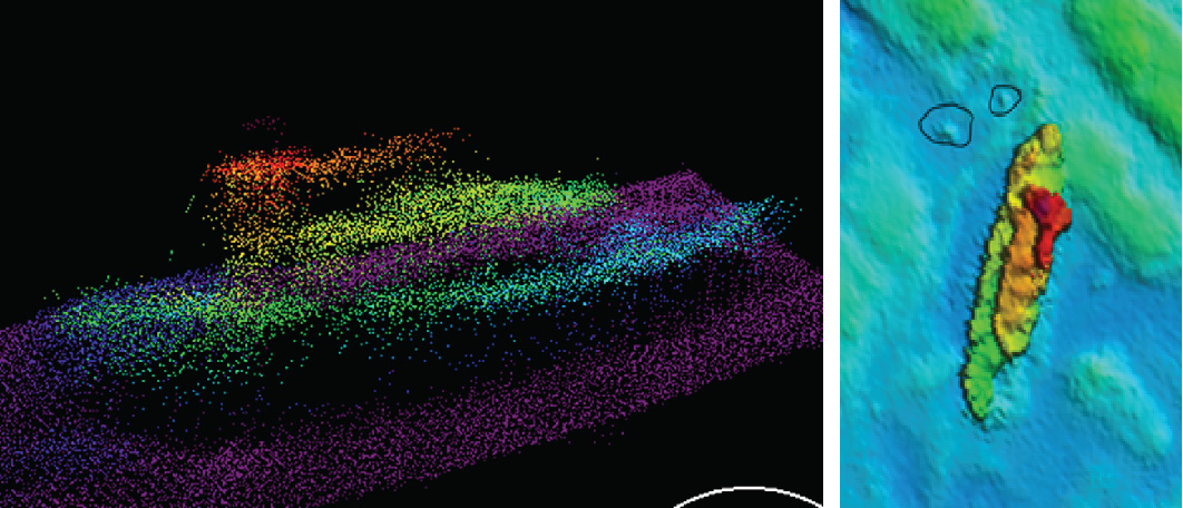
Mast of the sunken vessel found during the survey of Kodiak Island, AK, OPR-P136-RA-17. It was discovered by HAST Michael Bloom while on the NOAA Ship Rainier, in May 2017.
During the survey, Rainier was able to sail close enough to get multibeam echo sounder data over the shipwreck and record a shoal depth.
Multibeam echo sounder data depicting the shipwreck found off the coast of Long Island in Kodiak, Alaska.
Long Island was once the home ofFort Tidball, a World War II coastal fort established in 1941 and abandoned in 1946. NOAA received permission from the Alaska State Historic Preservation Office to share information about this shipwreck and is currently working to identify the ship.
Why is NOAA surveying around Kodiak Island? The area of Chiniak Bay supports the second busiest and third richest fisheries port in Alaska. In 2015, the Port of Kodiak was responsible for 514 million pounds of fish and $138 million of product. Chiniak Bay is the gateway to Kodiak and has a survey vintage of 1933. This area has seen many groundings and near misses due to the number of dangers to navigation and pinnacles that exist in this area. The navigation of this area is further complicated by the number vessels trying to enter and exit the Port of Kodiak via a choke point located at the channel entrance buoy. In recent years, a number of groundings in and around the area have occurred, the most famous being a 174-foot Army landing craft that was outbound to deliver goods to a remote village in western Alaska in 2012.
As the nation’s nautical chartmaker, NOAA Office of Coast survey serves a wide range of customers ranging from recreational boaters and operators of cargo ships, to historical chart enthusiasts. Customers throughout the world send us questions, comments, and also chart discrepancy reports, letting us know they found an error on a chart. As the Coast Survey “Answer Man,” I manage this communication, including Coast Survey’s response. Customers submit inquiries through our Inquiry and Discrepancy Management System (IDMS) database.
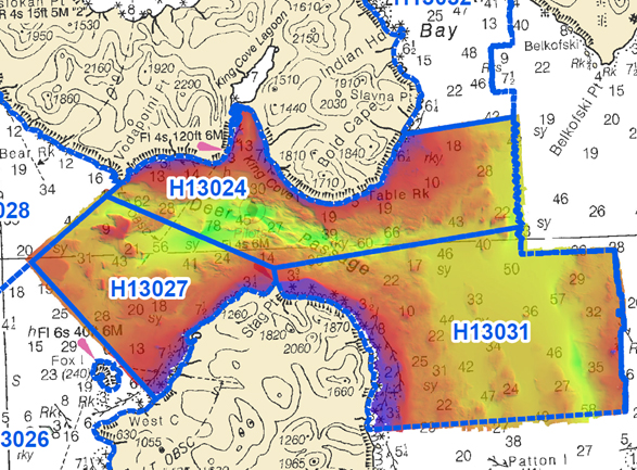
NOAA Ship Rainierhas been diligently surveying Deer Passage in the vicinity of Cold Bay and King Cove, Alaska, for the past month.
This navigationally significant area between Unga Strait and Sanak Island provides the only protected route for vessels transiting between the Gulf of Alaska, the very busy Unimak Passage, and the Bering Sea beyond. Deer Passage is heavily trafficked by fishing vessels, coastal freight traffic, and Alaska Marine Highway System ferries, and serves as an alternate route for deep-draft vessels on Trans-Pacific routes between North America and Asia. While in the area, Rainier observed particularly heavy use of the waterway by vessels engaged in local and Bering Sea fisheries, and towing vessels supporting remote Alaskan communities with barge service.
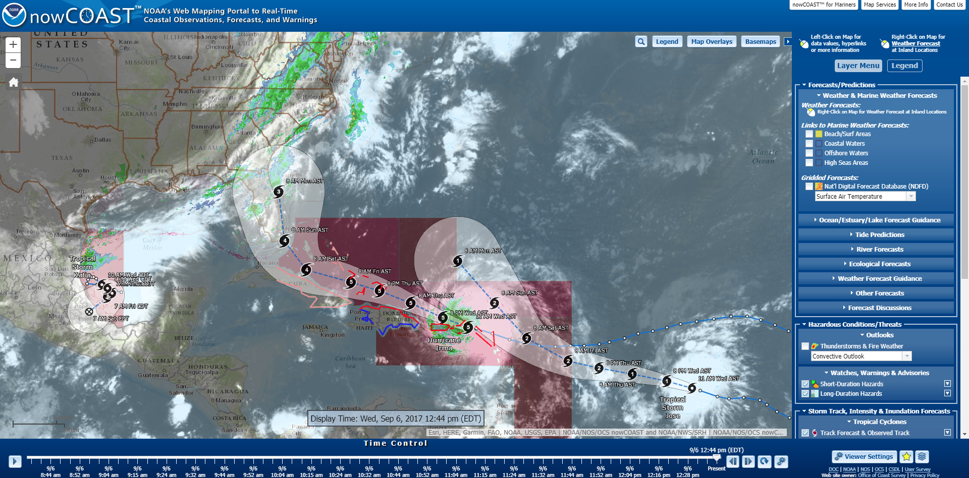
As Hurricane Irma approaches Puerto Rico as a Category 5 storm, NOAA is positioning personnel and hydrographic survey assets to help speed the resumption of shipping post storm. In the wake of a hurricane, NOAA’s personnel and survey assets provide essential information when ports need to quickly but safely re-open, limiting significant economic losses caused by prolonged disruptions to the maritime transportation system.