
By ENS Linda Junge
NOAA Ship Fairweather has been busy during the last couple months. Three major activities have broken up the peak summer months of this field season.
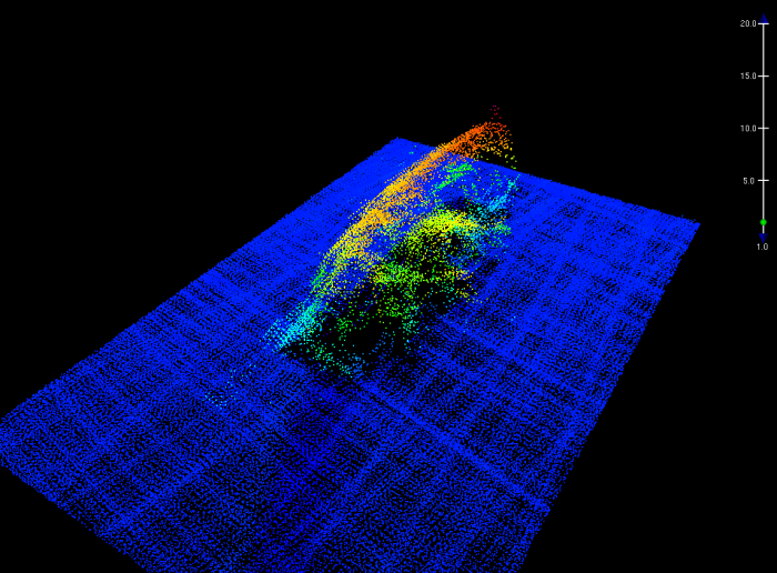
The Fairweather finds a sunken fishing vessel
The Fairweather located the wreck of the F/V Destination, a crabbing vessel that sank this past February off the coast of St. George Island in the Bering Sea. The disappearance of Destination had been the subject of a major U.S. Coast Guard search and rescue effort and subsequent investigation. The second NOAA research vessel to search for the Destination, Fairweather continued the efforts of the NOAA Ship Oscar Dyson, which looked for the sunken vessel in spring. Data collected by the Fairweather’s ship and launch sonars permitted multiple methods of visualization of the Destination as it rests on the seafloor, which will aid the Coast Guard.

The crew of Fairweather hopes that the finding of Destination might bring some closure to the families of the six fishermen who lost their lives in this tragedy. Now that the wreck has been located, the Coast Guard has continued their investigation in an effort to better understand circumstances which lead to Destination’s sudden sinking.
The Fairweather surveys the mouth of the mighty Yukon River, the longest river in Alaska!
Traveling from St. George Island, Fairweather arrived to the Yukon Delta on a calm morning in mid-July. After anchoring in shallow waters over 15 miles offshore, two launches were deployed to cruise to the river mouth. There, the survey launches—equipped with state-of-the-art multibeam sonar systems—picked their way up narrow winding channels to the main inland waterways. Fairweather’s survey team used AIS track histories, satellite-derived bathymetry (SDB), and local knowledge to guide their investigations and collect data from the delta’s main navigable channels.

This project was a great opportunity to compare SDB data to on-the-water reality observed on the launches. The Fairweather launches used colorful SDB images to estimate water flow, helpful in approximating the deeper channels.

The Yukon River is the most important supply route for most of interior western Alaska as well as the longest river in in the state. Thousands of people depend on the dry goods and fuel that are barged up and down the river every day. The mouth of the Yukon has not been surveyed since 1899. Since then, significant changes to the navigable channels and land masses of the delta have occurred on this dynamic river.


Safe shelter from the storm: the Fairweather surveys a critical Arctic port of refuge.
After arriving in Nome for a well-deserved port call, Fairweather set off again for the beginning of a new project area within the Arctic, the survey of Port Clarence. Port Clarence is a large bay located south of the Bering Strait. This natural harbor is a rare shelter along the exposed northwest coast of Alaska. As the Northwest Passage becomes more accessible, an increasing number of ships will need to seek shelter from the frequent storms of the Bering Sea. Port Clarence, now home to two small villages and with road access to Nome, may be poised to see more ship traffic in coming years.
Port Clarence is a large, flat area, perfect for side scan sonar (SSS) use. The crew of Fairweather outfitted two launches with Klein 5000 side scan units for use in the area, effectively tripling the survey coverage. Multibeam echo sounders were used concurrently with the SSS to confirm the depth of any rocks or obstructions.

Despite the sudden, violent squalls that frequent Port Clarence and slow the Fairweather’s survey progress, the crew has been knocking out huge segments of survey area. Soon the ship will be packing up and transiting to Yakutat in southeast Alaska, where the next survey awaits!
Is Fairweather seeing freshwater lensing or significant thermocline effects with their hull-mounted side scan sonar systems?