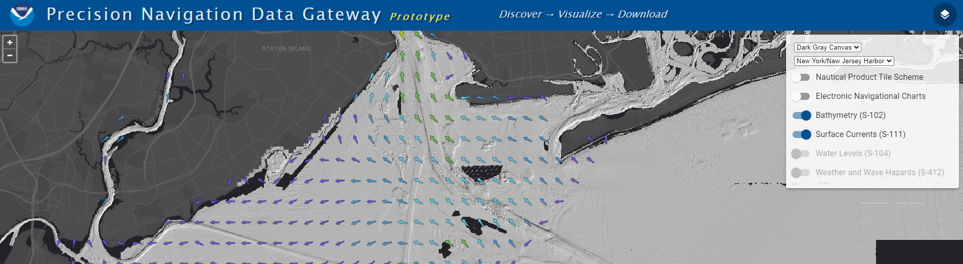
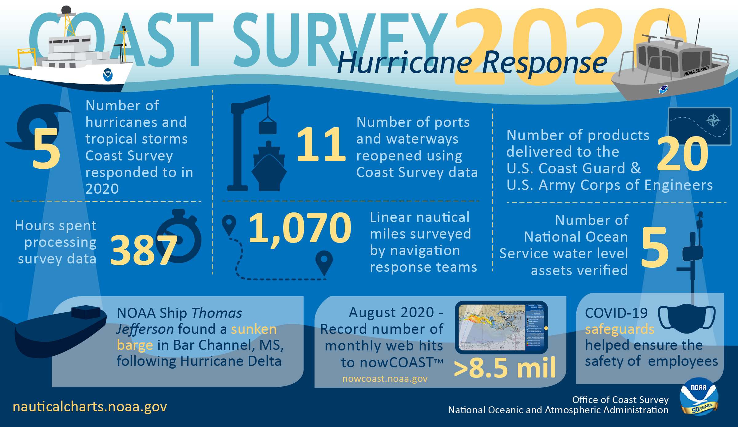
NOAA releases new visualization resources: Precision Navigation Data Gateway and Data Dashboard

NOAA’s Precision Marine Navigation (PMN) program released two new visualization resources. The first is a beta version Precision Marine Navigation Data Gateway map viewer allowing users to explore NOAA’s S-100 data services. Currently, the Data Gateway presents prototype surface current forecast guidance, but new layers will be added as they are developed. NOAA welcomes feedback on the beta version of the Data Gateway. Please submit all comments to marinenav.team@noaa.gov by March 1, 2021.

Continue reading “NOAA releases new visualization resources: Precision Navigation Data Gateway and Data Dashboard”

Introducing the Inland-Coastal Flooding Operational Guidance System (ICOGS)

Aerial imagery of inland-coastal flooding during Hurricane Harvey, 2017 in Houston, Texas.

Where the river meets the sea can be both a turbulent and vulnerable space, particularly during strong storms when heavy precipitation and storm surge intersect. This intersection is known as “compound inland-coastal flooding,” and until now, had not been carefully studied and implemented in forecasting centers for public guidance due to its inherent complexity. NOAA’s Office of Coast Survey and the Virginia Institute of Marine Science recently developed the Inland-Coastal Flooding Operational Guidance System (ICOGS), the world’s first three-dimensional integrated compound inland-coastal flooding guidance system.

Continue reading “Introducing the Inland-Coastal Flooding Operational Guidance System (ICOGS)”

By the Numbers: Coast Survey’s 2020 Atlantic Hurricane Season

NOAA Office of Coast Survey 2020 hurricane season infographic

As the 2020 Atlantic hurricane season came to a close on November 30, NOAA’s Office of Coast Survey tallied a few numbers to see what the combined response effort of the navigation response teams, NOAA Ship Thomas Jefferson, and hydrographic survey contractor David Evans & Associates, Inc., looked like.  

Continue reading “By the Numbers: Coast Survey’s 2020 Atlantic Hurricane Season”

NOAA Ship Thomas Jefferson returns to survey approaches to Chesapeake Bay during the 2020 field season

NOAA Ship Thomas Jefferson

By Hydrographic Assistant Survey Technician Sophia Tigges

For the first portion of the 2020 field season, NOAA Ship Thomas Jefferson surveyed approaches to Chesapeake Bay. Thomas Jefferson’s 2020 field season consisted of two 45-day “bubble” periods. A “bubble period” is the time a ship closes to personnel transfer while they shelter in place for seven days and undergo COVID-19 testing per NOAA’s Office of Marine and Aviation Operation’s COVID-19 protocol to mitigate exposure. The ship spent the entire first bubble working off the coast of North Carolina and Virginia for this project. These surveys served as a continuation of the ship’s work in the area in the 2019 season.  (To learn more about Thomas Jefferson’s work in this area last year, read the 2019 post titled, “NOAA Ship Thomas Jefferson tests innovative DriX unmanned surface vehicle.”

Continue reading “NOAA Ship Thomas Jefferson returns to survey approaches to Chesapeake Bay during the 2020 field season”

Coast Survey Spotlight: Meet Teresa Fleisher

Teresa Fleisher

Ever wonder what it’s like to be a member of the NOAA Coast Survey team? We use the Coast Survey spotlight blog series as a way to periodically share the experiences of Coast Survey employees as they discuss their work, background, and advice.


Teresa Fleisher, Program Specialist

“I love the work that we do, knowing that we’re contributing to making the country (and the world) a better – and safer – place.” 

Continue reading “Coast Survey Spotlight: Meet Teresa Fleisher”

Make your voice heard: Provide input on ocean mapping, exploration, and characterization efforts in the U.S. EEZ

Underwater scene

The National Ocean Mapping, Exploration, and Characterization Council (NOMEC Council), a group of federal agencies established to carry out the National Strategy for Mapping, Exploring, and Characterizing the United States Exclusive Economic Zone, requests your input on developing an Implementation Plan and setting strategic priorities for the effort to map the entire U.S. Exclusive Economic Zone (EEZ) by 2040 and explore and characterize strategic areas.

Continue reading “Make your voice heard: Provide input on ocean mapping, exploration, and characterization efforts in the U.S. EEZ”

NOAA concludes hydrographic survey response following Hurricane Delta

NOAA Ship Thomas Jefferson Launch 2904 surveying the Bar Channel, Calcasieu, Louisiana Approach.

This week NOAA’s Office of Coast Survey concluded its hydrographic survey response following Hurricane Delta. At the immediate request of the U.S. Army Corps of Engineers (USACE), NOAA’s navigation response teams (NRTs) and NOAA Ship Thomas Jefferson surveyed areas within the Gulf Intracoastal Waterway (GIWW), Calcasieu Ship Channel, and the entrance to the channel. With lessons learned from the response to Hurricane Laura — the first major hurricane of the 2020 season and the first hurricane response during a pandemic — the teams and Thomas Jefferson successfully collected, processed, and delivered data to the USACE, identifying significant hazards to navigation and helping to ensure the timely reopening of waterways.

Continue reading “NOAA concludes hydrographic survey response following Hurricane Delta”

Autonomous vessel operations in the Arctic: Lessons learned from the Summer 2020 Mapping Mission

On May 28, 2020, four uncrewed vessels departed Alameda, California, to begin their transit across the Pacific Ocean, through Unimak Pass, across the Bering Sea, and into the Arctic. These small, uncrewed vessels, powered only by wind and sun, arrived at Point Hope, Alaska, in early August to start an ambitious project acquiring new depth data along the 20 and 50 meter depth contours from Point Hope to the Canadian border. This was the start of a challenging Arctic project that would contend with weather, sea ice, and equipment failures, all while avoiding potential conflicts with indigenous subsistence hunting. 

Continue reading “Autonomous vessel operations in the Arctic: Lessons learned from the Summer 2020 Mapping Mission”

Coast Survey Spotlight: Meet James Moy

James Moy with chart in background

Ever wonder what it’s like to be a member of the NOAA Coast Survey team? We use the Coast Survey spotlight blog series as a way to periodically share the experiences of Coast Survey employees as they discuss their work, background, and advice.


James Moy, Cartographer

“As a cartographer, I consider it a success if the updates to a chart are accurate and justified, reviewed by another with little or no revisions, and is deemed useful and safe for the public.

Continue reading “Coast Survey Spotlight: Meet James Moy”