Supporting the mighty Columbia River through strong partnerships

An image of the Hood River Bridge crossing the Columbia River.

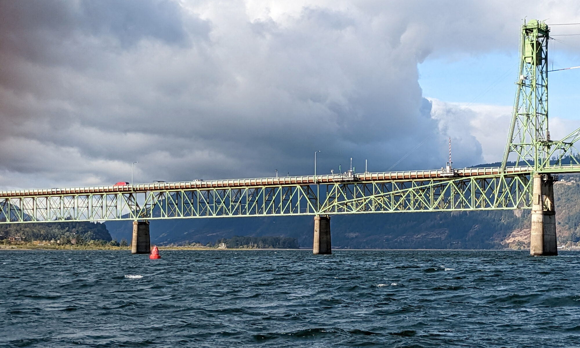
The Columbia River and its tributaries comprise one of the largest river systems in North America, flowing from British Columbia, Canada and through the United States to its final destination, the Pacific Ocean. The river is used extensively for transporting various cargoes into and out of the United States including forest products, grain, containerized cargo and bulk products like salt and cement. Upstream of Portland, barge and recreational traffic navigate the river to Kennewick, Washington or Lewiston, Idaho on the Snake River. For the people that use this river for its resources, this traffic almost assuredly has some type of ecological impact.

Continue reading “Supporting the mighty Columbia River through strong partnerships”

Geospatial information in the Southwestern Pacific

An image of the Island of Tarawa, part of the Republic of Kiribati in the Central Pacific.

By Dr. John Nyberg

An image of Dr. John Nyberg
Dr. John Nyberg

NOAA’s Office of Coast Survey Deputy Hydrographer Dr. John Nyberg participated in a State Department Science Fellowship through the U.S. Embassy in Suva, Fiji this past summer. The fellowship’s main goal for the region is to assist in accelerating the use of coastal and marine spatial planning for marine conservation and to deliver a curriculum to support it. Dr. Nyberg was asked to pay particular attention to engaging Kiribati (pronounced Kiribas), home to the Phoenix Islands Protected Area, one of the world’s largest and most important protected areas. The government of Kiribati is in the process of re-evaluating their approach toward managing the area, and one of the primary goals is to encourage the use of marine spatial planning in that process.

Continue reading “Geospatial information in the Southwestern Pacific”

NOAA Ship Thomas Jefferson completes productive field season in the Great Lakes

A graphic showing the route NOAA Ship Thomas Jefferson took returning back to Norfolk, Virginia after the 2022 field season.

Although NOAA has a significant presence in the Great Lakes, this is the first time a white-hulled NOAA hydrographic ship has deployed there since the early 1990s. As a result of survey work in the Great Lakes, NOAA Ship Thomas Jefferson surveyed 450 square nautical miles of lake bottom in Lake Erie – an economically important and ecologically sensitive region. The ship also surveyed 274 square nautical miles in Lake Ontario in October. In both lakes, there were 42 confirmed and new shipwrecks identified along with 22 additional features!

Continue reading “NOAA Ship Thomas Jefferson completes productive field season in the Great Lakes”

NOAA contributes to Empowering Women in Hydrography through at-sea experience, part 3

An image of Firosa Tomohamat, from Suriname’s Maritime Authority, sitting on a bench on deck 2 of NOAA Ship Thomas Jefferson.

The Empowering Women in Hydrography project is a global effort led by the International Hydrographic Organization and Canada that seeks to initiate, organize and track a series of activities and initiatives which will enable more women to participate equitably in the field of hydrography and to assume leadership roles within the hydrographic community. NOAA is contributing to the project via an ‘at-sea experience’ on NOAA hydrographic ships for three women each year over the four year lifespan of the project. After a global call for nominations, three women were selected to join NOAA ships for the 2022 survey season. Firosa Tomohamat from Suriname’s Maritime Authority, joined NOAA Ship Thomas Jefferson from August 8 to 26, 2022 while surveying the Great Lakes.

Continue reading “NOAA contributes to Empowering Women in Hydrography through at-sea experience, part 3”

Help keep nautical charts up to date through citizen science

A graphic showing an artistic Citizen Science banner.

NOAA maintains a suite of nearly 2000 electronic navigational charts (NOAA ENC®), as well as the ten volume United States Coast Pilot®. The seafloor and coastline are dynamic environments, which means that our products are constantly scrutinized for possible changes. Each year we make thousands of updates to ENCs, ensuring we are providing the most accurate products possible. The source data for most of these updates comes from NOAA or contractor surveys or from our federal partners, such as the U.S. Army Corps of Engineers and the U.S. Coast Guard. However, we also rely on many other data sources to help keep our ENCs up-to-date.

Continue reading “Help keep nautical charts up to date through citizen science”

NOAA contributes to Empowering Women in Hydrography through at-sea experience, part 2

NOAA ship Thomas Jefferson from survey launch 2904 at sunrise.

The Empowering Women in Hydrography project is a global effort led by the International Hydrographic Organization and Canada that seeks to initiate, organize and track a series of activities and initiatives which will enable more women to participate equitably in the field of hydrography and to assume leadership roles within the hydrographic community. NOAA is contributing to the project via an ‘at-sea experience’ on NOAA hydrographic ships for three women each year over the four year lifespan of the project. After a global call for nominations, three women were selected to join NOAA ships for the 2022 survey season. Chiaki Okada from the Hydrographic and Oceanographic Department, Japan Coast Guard, joined NOAA Ship Thomas Jefferson from July 25 to August 6, 2022 while surveying the Great Lakes.

Continue reading “NOAA contributes to Empowering Women in Hydrography through at-sea experience, part 2”

NOAA contributes to Empowering Women in Hydrography through at-sea experience, part 1

An image showing all woman officer hydrographers standing in front of NOAA Ship Rainier.

The Empowering Women in Hydrography project is a global effort led by the International Hydrographic Organization and Canada that seeks to initiate, organize, and track a series of activities and initiatives which will enable more women to participate equitably in the field of hydrography and to assume leadership roles within the hydrographic community. NOAA is contributing to the project via an ‘at-sea experience’ on NOAA hydrographic ships for three women each year over the four year lifespan of the project. After a global call for nominations, three women were selected to join NOAA ships for the 2022 survey season. Sub-Lieutenant Mercy Modupe Ogungbamila from the Nigerian Navy joined NOAA Ship Rainier from July 5 to 15, 2022 while surveying from Guam to Saipan.

Continue reading “NOAA contributes to Empowering Women in Hydrography through at-sea experience, part 1”

NOAA-NSF collaboration – evaluating coastal models utilizing Texas Advanced Computing Center services

The Unified Forecast System (UFS) is a proposed community-based earth modeling system that is designed to incorporate oceanographic forecast model core(s) into a simplified NOAA modeling suite. This simplification is intended to reduce the footprint of the number of NOAA models and thus reduce development, operations, and maintenance.

Continue reading “NOAA-NSF collaboration – evaluating coastal models utilizing Texas Advanced Computing Center services”

Surveying south of Cape Cod, Massachusetts in transit to the Great Lakes

NOAA Ship Thomas Jefferson underway in the Chesapeake Bay performing pre-season testing.

By Hydrographic Assistant Survey Technician Sarah Thompson

April 10, 2022 marked the beginning of NOAA Ship Thomas Jefferson and her crew’s field season and transit up through the St. Lawrence River, Lake Ontario, and into Lake Erie. This field season, Thomas Jefferson’s base of operations will be in Cleveland, Ohio and has the distinction of being the first NOAA ship to survey the Great Lakes in over 30 years. On the way, Thomas Jefferson had the opportunity to respond to a U.S. Coast Guard request to survey and obtain modern bathymetry on Pollock Rip Channel off the Massachusetts coast.

Continue reading “Surveying south of Cape Cod, Massachusetts in transit to the Great Lakes”

Ocean and coastal mapping matching fund opportunity

A graphic showing Rear Admiral Richard Brennan over a background of bathymetry

The Office of Coast Survey invites non-federal entities to partner with NOAA National Ocean Service’s ocean and coastal mapping programs on jointly funded projects of mutual interest using NOAA’s geospatial contracting vehicles. Known as the Brennan Matching Fund, the opportunity relies on NOAA’s mapping, charting, and geodesy expertise, appropriated funds, and its authority to receive and expend matching funds contributed by partners to conduct surveying and mapping activities. Partners benefit from this opportunity by leveraging NOAA’s contracting expertise, including its pool of pre-qualified technical experts in surveying and mapping as well as data management to ensure that the mapping data are fit for purpose and are usable for a broad set of purposes, including, for example, safe navigation, integrated ocean and coastal mapping, coastal zone management, renewable energy development, coastal and ocean science, climate preparedness, infrastructure investments, and other activities.

Continue reading “Ocean and coastal mapping matching fund opportunity”