The Unified Forecast System (UFS) is a proposed community-based earth modeling system that is designed to incorporate oceanographic forecast model core(s) into a simplified NOAA modeling suite. This simplification is intended to reduce the footprint of the number of NOAA models and thus reduce development, operations, and maintenance.
Focusing on three main themes
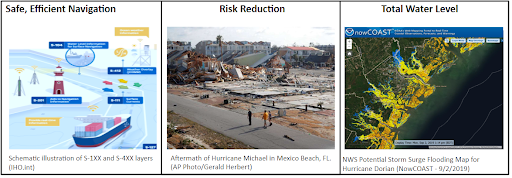
The UFS Coastal Applications Team (CAT) on water quantity, are focusing on three main themes: Safe and Efficient Navigation, Risk Reduction, and Total Water Level . The term water quantity here refers to the physical properties of hydrodynamic models. Under the UFS CAT effort, NOAA is collaborating with other agencies and academic partners, identifying coastal applications and defining evaluation approaches for selecting operational models. Over the past year, the UFS CAT sub-application groups created a list of coastal (hydrodynamic) models identified as prime candidates for each of the coastal application themes, along with user requirements and key variables such as water levels, surface water currents, sea and lake ice, and water temperature and salinity. The team is now in the second phase which is model evaluation for each sub-application.

The team members of the Coastal Application Team consist of NOAA, academia and other government agency employees. The co-leads that are responsible for designing and implementing UFS modeling strategies that guide the team members and sub-application teams include: Shachak Pe’eri (NOAA, National Ocean Service), Andre Van Der Westhuysen (NOAA, National Weather Service), Philip Chu (NOAA, Oceanic and Atmospheric Research), Reginald Beach (Navy, Office of Naval Research), and Kevin Haas (Georgia Tech, School of Civil and Environmental Engineering).
The evaluation process
The key success for the evaluation process is the ability to work on National Science Foundation (NSF) supported supercomputers. This provides a sandbox for allowing agency partners, model developers, and academic partners participating in model evaluation to investigate the performance of different coastal and ocean models. Therefore the NOAA-NSF efforts on providing such a collaborative environment are similar to the eventual NOAA operational environment.
The University of Texas at Austin’s Texas Advanced Computing Center (TACC), which designs and operates powerful computing resources, will house the NOAA UFS coastal application and evaluation computational infrastructure. The center’s mission is “to enable discoveries that advance science and society through the application of advanced computing technologies.”
The evaluation computation and related collaboration will take place on TACC’s Frontera supercomputer. Frontera is intended to contribute to TACC’s urgent computing capabilities, which have been utilized for the COVID-19 crisis as well as for storm surge modeling during hurricanes. In the coming years, it will also support rapid responses to emergencies like earthquakes, tornadoes, and other large-scale disasters.

NOAA and its agency and academic partners will utilize the TACC Frontera supercomputer as a vital part of the UFS model evaluation process to:
- Communicate with model developers to match expectations on the process and receive feedback, including optimizing the latest stable model on the platform in terms of memory and compiler options.
- Identify academic and government testers. NOAA’s National Ocean Service will be providing partial funding to support their testing and evaluation efforts. Testers must be at least graduate students with experience in coastal and ocean modeling.
- Perform skill assessment and required documentation to developers and testers.
This model evaluation is a cross-agency effort in collaboration with academic partners. Students and government employees will perform standard test runs on Frontera for a given region and a given specified computational time to allow fair quantitative model intercomparison and their performances for a given sub-application. National Ocean Service participation includes modelers and testers from the Center for Operational Oceanographic Products and Services, Integrated Ocean Observing System, National Geodetic Survey, and Office of Coast Survey.
The USF CAT members are currently interviewing model developers for participating in the evaluation. Over the Summer period (May-August, 2022), the team will provide model developers and testers (academic and government) access to compile and test the model candidate on the TACC infrastructure using standard test cases. During the fall season and through the next two years, a set of evaluations will be conducted to:
- Evaluate the model independently from other models.
- Evaluate the model coupled (forcing) with NOAA atmospheric forecast model.
- Evaluate the model coupled with atmospheric and wave forecast models.
- Evaluate the model coupled with atmospheric and wave and hydrological forecast models.
It is important to note that the models participating in the evaluation are evaluated against the three application themes and not against each other. The duration of each evaluation round is estimated to be about six months.
For more information on the use of NSF’s TACC for NOAA’s engagement with the modeling community on its coastal and ocean models, please contact Dr. Saeed Moghimi at Saeed.Moghimi@noaa.gov.
