Office of Coast Survey
National Oceanic and Atmospheric Administration
U.S. Department of Commerce
Office of Coast Survey
National Oceanic and Atmospheric Administration
U.S. Department of Commerce
March 9, 2022
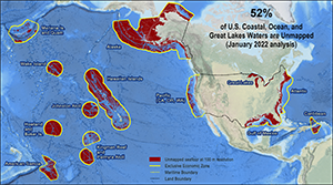 Geographic distribution and extent of the unmapped areas within U.S. ocean, coastal, and Great Lakes waters.
The Interagency Working Group on Ocean and Coastal Mapping (IWG-OCM) has released the third annual report on the progress made in mapping U.S. ocean, coastal, and Great Lakes waters. Knowledge of the depth, shape, and composition of the seafloor has far-reaching benefits, including safer navigation, hazard mitigation for coastal resilience, preservation of marine habitats and heritage, and a deeper understanding of natural resources for sustainable ocean economies. The 2020 National Strategy for Mapping, Exploring, and Characterizing the United States Exclusive Economic Zone and the global Seabed 2030 initiative make comprehensive ocean mapping a priority for the coming decade. The Unmapped U.S. Waters report tracks progress toward these important goals. For more information, check out our blog or contact Meredith.Westington@noaa.gov.
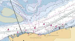 NOAA Chart Display Service rendering of ENC data along the Columbia River with traditional paper chart symbology.
The new NOAA Chart Display Service (NCDS) renders NOAA electronic navigational chart (NOAA ENC®) data with traditional paper chart
symbology in online and offline applications for which a basemap of nautical chart data is desired, including GIS, web-based, and mobile mapping applications. The new service uses symbols, labels, and color schemes familiar to those who have used NOAA paper nautical charts or the NOAA Custom Chart application. NCDS is available as Esri REST Map Service, OGC Web Map Service (WMS), and MBTiles formats. The NCDS replaces the Raster Navigational Chart (RNC) Tile Service and the Seamless RNC Service. These services are being shut down on March 15 as part of NOAA's continuing transition away from traditional paper and raster nautical charts. Special thanks goes out to Leland Snyder and Jeremy Wetzel who were integral in getting this service up and running. For more information, see our blog post.
The Office of Coast Survey's new BlueTopo webpage provides information and access to a compilation of the nation's best available bathymetric data. BlueTopo is unique in its acute attention to datum control, ability to account for changes in data quality over time, and method of compilation according to data quality metrics. Primary sources of bathymetry include NOAA and U.S. Army Corps of Engineers hydrographic surveys and topographic bathymetric (topo-bathy) LiDAR (light detection and ranging) data. BlueTopo is available to download through NOAA's big data project and will be available to view on nowCOAST™ in the near future. For more information please contact Katrina.Wyllie@noaa.gov or Glen.Rice@noaa.gov.
The International Hydrographic Organization's Worldwide Electronic Navigation Database Working Group (WEND) met in Monaco and virtually in a hybrid format on February 22-24, gathering approximately 65 participants from Asia, Europe, and the Americas. John Nyberg chaired the meeting and Julia Powell led the U.S. delegation. Participants discussed the process of handling new digital data, products, and services which include information about water levels, surface currents, high-resolution bathymetry, nautical publications, and S-101 electronic navigational charts. Key accomplishments for the week included reviewing the work of the WEND S-100 Implementation Guidelines and agreeing on a way forward to consolidate behind two use cases – SOLAS navigation and uses other than navigation. The key outcome was that the working group agreed to follow the United Nations principles for the non-navigation use case. For more information contact Julia.Powell@noaa.gov.
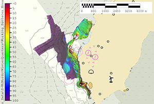 Bathymetric data collected in McMurdo Sound, Antarctica.
The Navigation Response Branch Antarctic team has returned home after 86 days afloat on the USCG Cutter Polar Star. The team acquired two square nautical miles (33.3 nautical miles) of survey data across six project areas, including two previously unsurveyed areas. The team is working on a blog post which will further elaborate on all their adventures. For more information contact Chief.NRB.OCS@noaa.gov.
 Caleb Taylor
Caleb Taylor joins Coast Survey as a program and policy analyst in the front office. He is focused on fostering strong legislative, interagency, and external stakeholder relationships for effective advocacy and application of Coast Survey services. Interested in making a difference utilizing science and policy, Caleb earned a master's degree researching coastal restoration ecology at Louisiana State University (LSU). He worked with university leaders to improve graduate student life and retention as vice president of LSU's graduate student association. Upon graduating from the university, he cut his teeth in the maritime world by working as a commercial crabber, landing craft deckhand, and longshoreman in Kodiak, Alaska, before gaining honest employment as a 2021 Knauss fellow in Washington, D.C. There he served with the U.S. Committee on the Marine Transportation System (CMTS) as a policy advisor to the executive director and staff lead on interagency team efforts for improving U.S. arctic marine infrastructure, maritime innovative science and technology, ocean policy, environmental justice, and offshore energy facilitation. Fun facts: Caleb thru-hiked the Appalachian Trail in 2016, has been charged by brown bears on two separate occasions, and went to the same high school as Britney Spears. Welcome Caleb!
did you know?
NOAA and other interagency collaborators recently released the Sea Level Rise Technical Report providing the most up-to-date sea level rise projections available for the United States. The report is the latest product of the Interagency Sea Level Rise and Coastal Flood Hazard and Tool Task Force which includes NOAA, EPA, NASA, USGS, and USACE. Additional support was provided by the U.S. Department of Defense Strategic Environmental Research and Development Program. Listen to Episode 52 of NOAA Ocean Podcast where two members of the Federal Sea Level Rise Task Force discuss the new report. Additional information on this report and other sea level topics are on the Sea Level Rise Portal.