An
official website of the United States government.
Here's how you know we're official.
An
official website of the United States government.
Here's how you know we're official.
An
official website of the United States government.
Here's how you know we're official.
An
official website of the United States government.
Here's how you know we're official.
Storm Surge Modeling
The Office of Coast Survey hosts the National Ocean Service's Storm Surge Modeling Team, which develops modeling infrastructures for end users to perform disaster risk assessments and prediction capabilities to reduce and mitigate coastal vulnerability to natural disasters. These products improve communication and collaboration with national and international agencies by understanding charting, bathymetry, water level, currents, and other NOAA products. Such efforts also support products and services that are vital for: 1) safe maritime navigation, 2) world class geodetic infrastructure, and 3) sustainable use of ocean resources for economic health and growth.
Some of the NOS Storm Surge Modeling Team's key development and operational activities include:
STOFS (Surge and Tide Operational Forecast System)
The Surge & Tide Operational Forecast System (STOFS) is one of the oldest-running coastal surge operational forecast systems developed by NOAA's Office of Coast Survey in collaboration with other NOS, NWS, and academic partners.
From 2012 to 2020, the ADCIRC-based ESTOFS (STOFS was formerly called Extratropical Surge & Tide Operational Forecast System) was deployed for the US East and Gulf Coasts and the Caribbean (ESTOFS-Atlantic), US West Coast and Hawaii (ESTOFS-Pacific), and for the US Territories in Micronesia from Palau to Marshall Islands (ESTOFS-Micronesia). Global STOFS (STOFS-2D-Global) became operational in late 2020 and replaced the three existing operational domains with better spatial resolution and superior physics. STOFS-2D-Global was upgraded three times from 2020-2024 (July 2021, January 2023, May 2024) to improve model performance, resolution, and coverage. In addition, the SCHISM-based 3-D STOFS component for the Atlantic Basin (STOFS-3D-Atlantic) was implemented into operations in January 2023 as the first SCHISM-based operational model at NOAA. STOFS-3D-Atlantic was also upgraded in May 2024. In late 2025/early 2026, STOFS will undergo another upgrade for these two components, and a third component—SCHISM-based STOFS-3D-Pacific—will be put into operations.
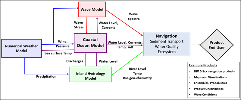
Model Coupling and Unified Forecast System
The effort is aimed to interface and enhance other NOAA coastal modelling capabilities such as: hydrological models, wind models, and other multi-physics interaction through Earth System Model Coupling efforts. Several NOAA-wide efforts are supporting Earth System Model Coupling with a focus on nearshore and coastal environments such as COASTAL Act Program and NOAA Water Initiative. NOAA's Office of Coast Survey in coordination with other NOAA line and NOS program offices will continue developing and testing new modelling paradigms to support NOAA's mission in improving the safety and efficiency of commercial shipping; proactively preventing and mitigating and responding to natural hazards (e.g., compound inland-coastal flooding).