Office of Coast Survey
National Oceanic and Atmospheric Administration
U.S. Department of Commerce
Office of Coast Survey
National Oceanic and Atmospheric Administration
U.S. Department of Commerce
April 13, 2022
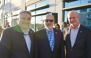 From left to right: Nicolas Alvarado, Richard Spinrad, and Neil Weston at the opening ceremony for the Maritime and Defense Technology Hub.
On March 2, Nicolas Alvarado and Neil Weston attended the opening ceremony of the St. Petersburg, Florida Maritime and Defense Technology Hub proposed for the Innovation District. The 30,000 square foot space is being leased to several companies such as Saildrone, Pole Star Defense, and Woolpert and is expected to bring together several tenants including those in industry, private sector, academia, local and federal government agencies. Currently the University of South Florida, NOAA, USCG and the USGS are located adjacent to the Hub and will serve as foundational agencies to the area. The primary goal is to provide a collaborative area to foster technology growth and innovation as well as to support the local economy with jobs and expertise in coastal management, oceanography, and engineering. For more information, contact Neil.D.Weston@noaa.gov.
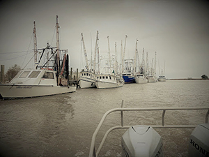 An image of the Darien River fishing fleet taken from the Navigation Response Team survey vessel.
Coast Survey's first survey of the Darien River was conducted in 1868. Sixty-six years later, in March of 1934, D.E. Sturmer, M.G. Elliott and crew boarded the launch Mikawe to commence a survey of the Darien River out to the newly established intracoastal waterway. Eighty-eight years to the month later, Coast Survey returned to provide an update. During the week of March 11, Navigation Response Team 2 Team Lead James Kirkpatrick and Southeast Navigation Manager Kyle Ward met in the fishing community of Darien, Georgia to revisit the waterway and conduct a survey. The survey was in response to a request from the U.S. Coast Guard and the local fishing fleet to identify unmarked shoals and obstructions. New shoals and foul areas were found and reported as dangers to navigation. While there have been a few changes in the river, the mission has stayed the same – providing accurate up-to-date charts to keep commerce flowing. For more information, contact Kyle.Ward@noaa.gov.
On March 7, members of the uncrewed systems (UxS) navigation response team attended the Marine Technology Society's Oceans in Action conference in Biloxi, Mississippi. Physical Scientist Alex Ligon participated in a panel discussion alongside CAPT Philip Hall (OMAO), Bill Lingsch (IOOS), and Sharon Mesick (NCEI) to outline the NOAA wide UxS strategic approach. The team was also able to showcase their systems alongside the Naval Oceanographic Office at the Advanced Naval Technology Exercise display. The team showcased three UxS assets (Echoboat 160, Echoboat 240, and Remus 100) that are currently active in the Navigation Response Branch. They highlighted the versatility and force multiplication that each of these systems bring to the table during hurricane response and standard survey operations. The conference provided an opportunity to reestablish a relationship with the Naval Oceanographic Office and the University of Southern Mississippi's Hydrographic Science Program, which was put on hold due to the pandemic. The team also met with OMAO's UxS leadership to discuss operations and implementation into the soon to be completed Roger F. Wicker Center for Ocean Enterprise building, which will house OMAO's UxS Operation Center and the UxS response team starting next year. The team is currently operating out of the Port of Gulfport in an effort to have all systems calibrated and ready for deployment this summer. For more information, contact Collin.McMillan@noaa.gov.
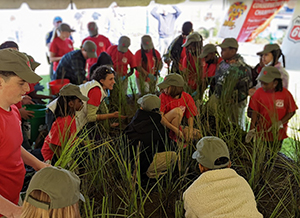 Students and teachers preparing the grass mats for installation into Prien Lake, Louisiana.
On April 1, Central Gulf Coast Navigation Manager Tim Osborn, participated in a large environmental education and coastal restoration effort with the installation of various native plants on Prien Lake, Louisiana. The plants were rooted on large floating mats, which were then floated onto the water and anchored in place at specific locations. The floating marsh islands program has become ubiquitous along the Gulf Coast in the past several years and provides an opportunity for thousands of school children to learn about the coast and help in local community coastal restoration projects. This event was attended by 125 students from local grade schools, and was sponsored by the Louisiana Coastal Conservation Association, Phillips 66, Stream Enterprises, and Calcasieu Parish elected officials. For more information, contact Tim.Osborn@noaa.gov.
 An image showing automatically generated mesh based on Hurricane Florence's track in 2018 using OCSMesh.
The first version of OCSMesh has been released following the publication of a NOAA technical memorandum describing its various aspects and capabilities. OCSMesh is a data-driven automated unstructured mesh generation software for coastal ocean modeling, developed by the NOS Storm Surge Modeling team in NOAA's Office of Coast Survey, Coastal Marine Modeling Branch. OCSMesh capabilities such as automated digital elevation model processing and mesh cleanup make it a convenient tool for modeling beginners and a powerful buzz saw for experienced modelers. The tool will simplify node selection from elevation grids that can be used for unstructured coastal ocean models. OCSMesh can be used in command line mode for better integration with automated workflows or as a Python library to support higher level coastal modeling application development. This effort is supported by the NOAA COASTAL Act program and the NOAA National Oceanographic Partnership Program project for developing an automated operational mesh generation and simulation system. The source code for OCSMesh is available on GitHub at noaa-ocs-modeling. For more information contact Soroosh.Mani@noaa.gov.
did you know?
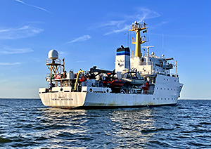
NOAA Ship Thomas Jefferson is headed to the Great Lakes this season and is preparing to survey several areas in multiple locations. This effort was recently highlighted in an article posted by Michigan Live – On first mission to Great Lakes, NOAA ship will sonar map Lake Erie.