A Coast Survey hydrographic team recently found a special holiday wish during their survey of the seafloor. We share it with you, along with our sincere hopes for a spectacular 2013!
(To play video, click button in middle of image)
[wpvideo 8ZAIc5dQ]
This video was created by Ian Colvert, a survey technician with Coast Survey’s Navigation Response Team 6. (Who can guess why he added a “smiley face” at the end of the greeting? Leave your answer in the comments.)
By David McIntire, survey technician, Coast Survey Navigation Response Team 4
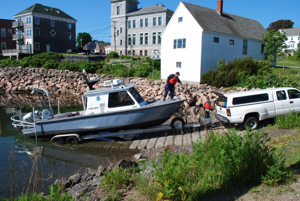
Down East Maine. For many, this conjures up imagery of rugged, fog-enshrouded coastline carved for centuries by relentless waves and violent nor’easters, where quaint fishing villages and misty lighthouses hug the shoreline, inhabited by hardy mariners who for generations have braved fierce storms and unimaginable winters to make a living where land and sea meet in perhaps the most spectacular way. Yet this is only part of the story where a nostalgic past embraces an innovative future. Eastport, Maine is no exception and NOAA’s Office of Coast Survey is proud to partner in that endeavor.
Fishing has been the lifeblood of Eastport’s economy for generations and, despite the influx of tourism in recent decades, many Down East families still derive their income from the sea. This may sound quaint and romantic, until you realize that the Bay of Fundy is not the idyllic, placid water of postcards and paintings. With tides ranging nearly 30 feet every few hours, inlets become rife with ripping currents as the back bays fill and empty through these narrow, rocky channels. It is within this treacherous environment that the local commercial fishermen risk their lives – and, over the past decade, a number of them have paid the ultimate price. A navigation response team deployed to Maine’s dangerous Cobscook Bay in 2010. The Eastport fishing community asked for full bottom surveys and updates to nautical charts after several men lost their lives when their boats capsized. Continue reading “Surveys for Maine fishing community buttress new energy technology”
During the first six months of the Coast Survey blog, we have focused largely on the field work – surveying sparsely charted Arctic waters, responding to calls for help following hurricane destruction, finding dangers to navigation, and even identifying historic wrecks. We haven’t covered the day-in, day-out job that is our reason for existence: creating and updating the country’s nautical charts.
Coast Survey has compiled and maintained the nation’s nautical charts for nearly two centuries, after President Thomas Jefferson approved legislation in the Ninth Congress in 1807, and we now maintain a suite of over a thousand charts. We sometimes get the question, “aren’t you done yet?” Haven’t we finished charting all of the U.S. waters? Coast Survey issued new Kotzebue chart 16161, partially depicted here, in May 2012.
The simple answer is no: because storms alter seafloors, and water depths constantly change due to shifting shoals, submerged hazards, and coastal development, Coast Survey must continually update the nation’s nautical charts. Charting those changes, and ensuring chart accuracy and precision, is essential to protecting life and property.
The more complicated answer may surprise you. Many of our nation’s marine shipping lanes, harbors, and port areas haven’t been mapped since the 1920s, when measurements weren’t as precise – or even as accurate ‒ as is possible now. Some areas, especially in Alaska, haven’t had bottom measurements since the mid-1770s.
Coast Survey’s Marine Chart Division employs many of the nation’s best cartographers. Since 2009, cartographers have applied approximately 50,000 critical charting corrections to NOAA’s various charting products. In fiscal year 2012 alone, cartographers applied more than 11,000 critical corrections to chart updates.
Over those four years, Coast Survey has also produced over 500 new chart editions (of current charts), and built 200 new NOAA ENC® (NOAA electronic navigational charts). This includes 155 new chart editions and 56 new ENCs in fiscal year 2012.
This year, Coast Survey produced several brand new nautical charts, including a new chart for the Port of San Juan, Puerto Rico, and for the Kotzebue Harbor in Alaska, where increasing ocean commerce required improved navigational products. Coast Survey also released an updated chart of Norfolk Harbor, with a new inset of the Inner Harbor, which has developed as a multi-purpose port area.
In addition to updating old charts, and creating new ones, Coast Survey is making more information accessible from its electronic navigational charts. Effective early 2012, several of NOAA’s ENCs that cover the approaches to the East Coast now alert mariners when they are approaching the right whale seasonal management areas, giving them better information to plan to reduce their speeds or avoid the areas altogether. The seasonal management areas, as encoded into the ENCs, graphically show the areas where vessels greater than 65 feet in length must travel at 10 knots or less to reduce the risk of collisions with right whales. The ENCs will also provide for an alarm on the ship’s electronic chart display and information system as vessels enter the speed zone, further alerting the bridge watchstander of speed restrictions.
We are seeing a gradual shift from paper nautical charts to raster navigational charts and electronic navigational charts. Over the last four years, the public has purchased nearly 428,000 print-on-demand paper charts, and another 392,000 traditional paper charts. Reflecting the booming technology in navigation, the public has downloaded countless millions of the electronic and raster navigational charts that NOAA offers free on the Internet.
Even while cartographers use their expertise to update and innovate, there is still the matter of uncharted U.S. waters – waters that remain to be surveyed. Coast Survey is mandated to provide nautical charts for all U.S. territorial waters and the U.S. Exclusive Economic Zone, a combined area of 3.4 million square nautical miles that extends 200 nautical miles offshore from the nation’s coastline. A complete survey of all of those waters would require 545 ship years and $5 billion just to acquire the data. Lacking those resources, NOAA has instead established priorities for the hydrographic surveys that acquire data necessary for reliable charts. Those priorities are updated annually, and are available on Coast Survey’s website, as NOAA Hydrographic Survey Priorities.
A critical need for new or updated charts is especially emerging in the Arctic, and Coast Survey’s Arctic Nautical Charting Plan addresses the tasks ahead.
Commercial mariners and recreational boaters will always rely on NOAA’s charts to keep them and their passengers and cargo safe from harm. NOAA’s cartographers will always work to earn that trust.
— Additional resource:
If you note a chart discrepancy, please report it through our online service.