
NOAA and the U.S. Coast Guard recently released the Cooperative Maritime Strategy developed by the two agencies. The introduction to the document, signed by Admiral Papp and Dr. Lubchenco, is a stirring testament to our shared legacy and commitment. We reprint that introduction here.
25 February 2013

We are pleased to promulgate our Nation’s first-ever Cooperative Maritime Strategy between the United States Coast Guard and the National Oceanic and Atmospheric Administration. For over 200 years, our Services have stood in partnership on maritime resilience, environmental sustainability, and scientific research. Indeed, America is a maritime nation, and the oceans, coasts, rivers and Great Lakes are the lifeblood of our economy. The maritime commons promote economic growth, advance technology, and challenge the human spirit. Our Services share a legacy and are committed to a future that honors our responsibilities as stewards of the oceans.
Continue reading “NOAA and Coast Guard release Cooperative Maritime Strategy”
Coast Survey publishes new international chart for navigation between Florida and Cuba
As the nation’s nautical chartmaker, Coast Survey produces the country’s traditional paper charts for coastal waters, territorial waters, and the Great Lakes. We maintain the Print-on-Demand charts that you can purchase from OceanGraphix and East View Geospatial. We make the nation’s raster navigational charts (NOAA RNC®) and electronic navigational charts (NOAA ENC®). And the free downloadable BookletCharts. But did you know we produce international charts, too? NOAA has five international charts covering the Northeastern Pacific Ocean and the Bering Sea… and we just published our sixth, for the opposite coast.
International mariners entering U.S. waters around southwestern Florida now have a new international (INT) nautical chart to help ease their transit. The new chart, INT 4148, has the same information as Chart 11420, Havana to Tampa Bay, but the depictions are converted to the metric system. (Most U.S. charts use either feet or fathoms for depth measurements). INT charts also use some different symbology, so Coast Survey makes those modifications as well.
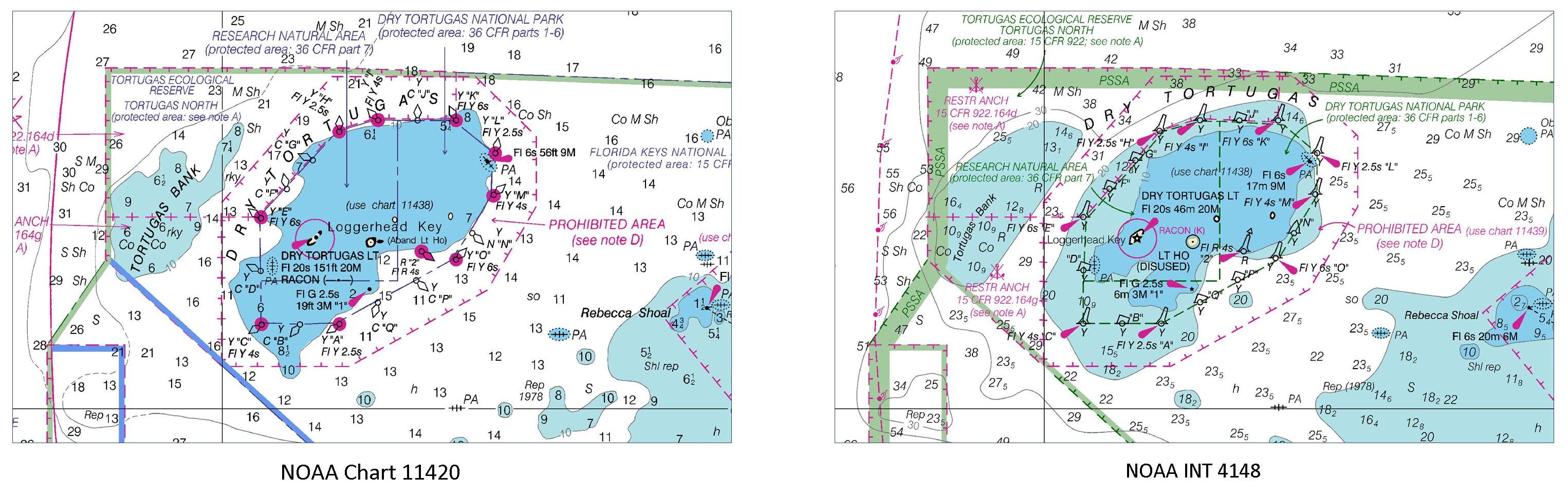
Continue reading “Coast Survey publishes new international chart for navigation between Florida and Cuba”
NOAA Ship Thomas Jefferson prepared for 2013 survey season
By Ensign Brittany Anderson, Junior Officer, NOAA Ship Thomas Jefferson
After a quiet winter at home port, the NOAA Ship Thomas Jefferson completed her sea trials this week in preparation for the 2013 field season.
Each year, prior to departing for working grounds, the Thomas Jefferson transits to the Chesapeake Bay to perform tests on the ship’s and launches’ systems and hydrographic survey equipment. Crews conduct numerous tests to check the accuracy and precision of multibeam echosounders, side scan sonar, and the sophisticated suite of programs that process all the data. Additionally, this is an opportunity to ensure the safety of the vessel and her crew by performing numerous safety drills and readdressing safety standards and operating procedures.

Continue reading “NOAA Ship Thomas Jefferson prepared for 2013 survey season”
A nation pays final tribute to Civil War sailors interred at Arlington National Cemetery
Last week we blogged about the Civil War sailors whose remains were being interred at Arlington National Cemetery on March 8. The funeral, for unknown sailors who were lost when the USS Monitor capsized, was solemn and stirring, and reflected the nation’s great esteem for our fallen patriots. The unknown sailors were lost along with 14 of their shipmates when Monitor sank off Cape Hatteras, N.C., on Dec. 31, 1862.
All 16 sailors will be memorialized on a group marker in section 46 of the cemetery, which is between the amphitheater and the USS Maine Mast memorial.
Rear Admiral Gerd Glang, Coast Survey’s director, was honored to represent NOAA in the officer escort for the caissons. Glang and Rear Admiral Anthony Kurta (USN) served as Escort Commanders, and were joined by Capt. Gary Clore (Navy Chaplain) and Cmdr. Nathaniel Standquist (U.S. Navy Ceremonial Guard), as the nation paid a final tribute.
Continue reading “A nation pays final tribute to Civil War sailors interred at Arlington National Cemetery”
NOAA Coast Survey director to escort caissons for USS Monitor sailors’ interment at Arlington
On Friday, March 8, a NOAA Corps admiral will have the honor of doing something extraordinary. Coast Survey’s director, Rear Admiral Gerd Glang, will be the NOAA Escort Flag Officer for the full honors funeral of two unknown sailors who went down with the Civil War ironclad USS Monitor in 1862. Rear Adm. Glang will join Rear Adm. Anthony Kurta, U.S. Navy, as the two officers escort the caissons during the somber event at Arlington National Cemetery.
The interment will be open to the public.

The Monitor sank southeast of Cape Hatteras, North Carolina, during a New Year’s Eve storm, carrying 16 crew members to their deaths.
The wreck was discovered in 1973, and confirmed in 1974 by John Newton and a team from Duke University. The ironclad was lying upside down with the turret separated from the hull, resting in 230 feet of water approximately 16 miles off Cape Hatteras. In the late 1990s through 2002, experts recovered iconic Monitor artifacts, which are now conserved at the Mariners’ Museum in Newport News, Virginia. Two skeletons were discovered in 2002 when the turret was raised from the seafloor, and efforts to identify the remains have been unsuccessful so far.
Continue reading “NOAA Coast Survey director to escort caissons for USS Monitor sailors’ interment at Arlington”