Developing products for “precision navigation”

ship clearance at 1 degree pitch

Ports of Los Angeles and Long Beach are first up

by Capt. Richard Brennan, chief, Coast Survey Development Lab
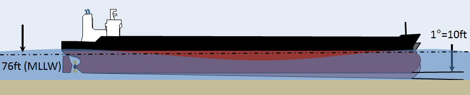
The increased size of vessels entering U. S. ports, coupled with the diminishing margins that must be navigated with reference to the seafloor, provides NOAA with the opportunity to develop new products to support precision navigation. The ports of Los Angeles and Long Beach are testing grounds for current product development, since developing products for these ports will allow us to examine the value of precision navigation products under actual at-sea conditions. The channel leading to the Port of Long Beach has an authorized depth of 76 feet, allowing drafts of 69 feet. A major concern for this port is high sea swell conditions that can be present when ultra large crude carriers enter port. These large swells can cause vessels to pitch, which results in a significant change in their draft.
Continue reading “Developing products for “precision navigation””

Coast Survey announces plans for 2015 NOAA survey projects

2015 survey plan outlines

In 2015, NOAA survey ships Thomas Jefferson and Ferdinand R. Hassler are scheduled to survey nearly 1,800 square nautical miles in the U.S. coastal waters of the lower 48 states, collecting data that will update nautical charts for navigation and other uses. In Alaska, NOAA ships Fairweather and Rainier will increase their Arctic operations, planning to acquire 12,000 nautical miles of “trackline” depth measurements of the U.S. Coast Guard’s proposed shipping route. (See this NOAA article.) The ships will also conduct several “full bottom” hydrographic survey projects, acquiring data from over 2,800 square nautical miles in survey areas along the Alaskan coastline.
We are also planning several projects for our contractual private sector survey partners, and those projects will be announced after work orders are finalized.
Continue reading “Coast Survey announces plans for 2015 NOAA survey projects”

Explore once, use many times

OE Survey W00286

This post is adapted from a poster at the U.S. Hydro 2015 conference, in National Harbor, Maryland.

Pilot project shows nautical charting applications using NOAA Ship Okeanos Explorer data

By
James J. Miller and Tyanne Faulkes, physical scientists, NOAA Office of Coast Survey, Atlantic Hydrographic Branch
Lindsay McKenna, physical scientist, ERT Inc. contractor with the NOAA Office of Ocean Exploration and Research
Mapping is the foundation of ocean exploration and marine spatial planning. In its mission to explore and broaden our knowledge of the oceans, the NOAA Ship Okeanos Explorer has collected high-resolution multibeam data as an integral part of its operations around the globe. Since 2013, the Office of Coast Survey has collaborated with the Okeanos Explorer during their expeditions, to improve hydrographic acquisition and processing methods and expand multibeam coverage in the Gulf of Mexico and Atlantic Ocean. The resulting bathymetry has supported a diverse array of oceanic research and contributed to the protection of ecologically critical habitats in U.S. waters.
Continue reading “Explore once, use many times”

NOAA hydro officers honored

Megan Guberski

Each year, the NOAA Association of Commissioned Officers recognizes NOAA Corps officers for their extraordinary accomplishments and contributions. This year, three of the four awards went to officers supporting Coast Survey’s hydrographic program. Congratulations to the officers honored with Junior Officer of the Year, Engineering, and Science awards. Coast Survey applauds your accomplishments!
Continue reading “NOAA hydro officers honored”