Coast Survey aids U.S. Coast Guard in recovering sunken buoy

This is a chartlet showing the location as well as measurements of the five different features found through multibeam sonar surveys of the NRT6.

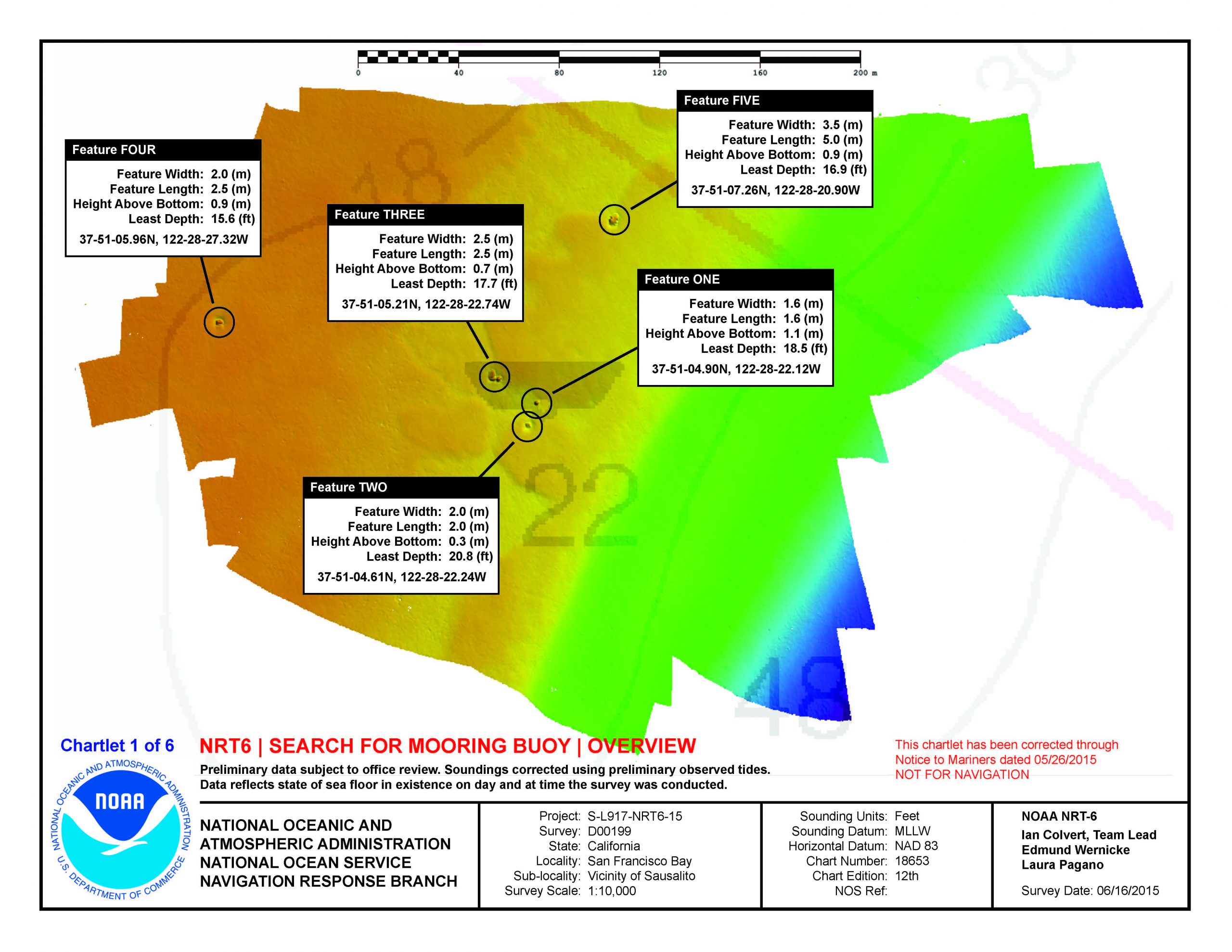
Coast Survey’s Navigation Response Team (NRT) 6 responded to a request from the U.S. Coast Guard to locate and facilitate recovery of a sunken mooring buoy near Sausalito, California.
Although not a threat to surface navigation, there are two reasons for this recovery effort. The first is to protect mariners from getting their anchors caught on the buoy or tangled in the mooring chain. Recovery will also allow the U.S. Coast Guard to repair and possibly reuse the buoy.
Continue reading “Coast Survey aids U.S. Coast Guard in recovering sunken buoy”

NOAA dedicates memorial at Absecon Lighthouse

Sunday, June 21, was World Hydrography Day, a day set aside to recognize the important work of hydrographers.  Measuring and describing the physical features of oceans, seas, and coastal areas is essential not only to the safe navigation of the everyday mariner, but to our nation’s economic development, security and defense, scientific research, and environmental protection.

Absecon lighthouse with NOAA flag
The NOAA flag flies at the Absecon Lighthouse during the memorial dedication. Photo by David Hall

This year’s observation was particularly noteworthy for NOAA, as we honored the lost crew members of the U.S. Coast Survey Steamer Robert J. Walker, by dedicating a memorial at the Absecon Lighthouse in New Jersey.
On June 21, 1860, the Robert J. Walker was hit by a commercial schooner while transiting from Norfolk to New York after months of surveying in the Gulf of Mexico. The ship sank 12 miles offshore, as they were heading to the Absecon Lighthouse after they were hit. Coast Survey lost twenty crew members that night, and another man died from his injuries the next day, in the largest single loss of life in Coast Survey and NOAA history.
Continue reading “NOAA dedicates memorial at Absecon Lighthouse”

Over 35,000 conductivity, temperature, and depth profiles added to public oceanographic database

Well before the invention of the computer and the following onslaught of digital data, S.R. Ranganathan in his 1939 book, “Theory of Library Catalogue,” described in detail how a library catalog should work and be prepared. Since then, the way we develop and maintain information databases and archives has dramatically changed. The format has morphed beyond traditional books and journals to large amounts of digital data.
The Office of Coast Survey alone produces digital data on order of several terabytes a year, and much of this data is collected by NOAA hydrographic survey vessels. In order to make the data easily accessible and available to the public, it is formatted and submitted to the National Center for Environmental Information (NCEI) ocean data archive. Here, the basic principles of library cataloging apply – find the appropriate information quickly and in the location it is supposed to be stored.

Map showing locations of recovered oceanographic profiles
Locations of recovered oceanographic profiles.

Continue reading “Over 35,000 conductivity, temperature, and depth profiles added to public oceanographic database”

Ceremony in Kodiak, Alaska, marks the deployment of NOAA ships Fairweather and Rainier

To mark the deployment of NOAA ships Fairweather and Rainier as they begin a summer of hydrographic survey projects in the Arctic, NOAA hosted a ceremony at the U.S. Coast Guard (USCG) base in Kodiak, Alaska.
The ceremony opened with a joint USCG and NOAA color guard while the national anthem was sung by retired USCG Chief Aviation Machinist Mate, Joe Symonoski. Rear Admiral Gerd Glang, director of the Office of Coast Survey, gave opening remarks.

Presentation of colors by a joint U.S. Coast Guard and NOAA color guard.

“Characteristically, we are quite modest about the missions and accomplishments of our NOAA ships. But today, we are taking the time to recognize the planned deployment of both ships to undertake hydrographic surveys in the U.S. Arctic,” Glang said. “It is important for us because of the renewed investment NOAA is making in this region at a time when the Arctic has become more accessible to marine transportation.”
Continue reading “Ceremony in Kodiak, Alaska, marks the deployment of NOAA ships Fairweather and Rainier”

Coast Survey helps communities prepare for the 2015 Atlantic hurricane season

Public preparedness meeting at Port Morgan City, Louisiana.

June 1 marks the beginning of the 2015 Atlantic hurricane season. Although NOAA projects it to be a below normal season, it doesn’t mean coastal areas will have it easy. In the wake of a hurricane, Coast Survey plays a critical role in NOAA’s response efforts. But what about before the storm? In addition to building relationships and coordinating emergency response capabilities with agencies such as  U.S. Coast Guard, U.S. Army Corps of Engineers, and port authorities, Coast Survey focuses on local community preparedness meetings and outreach events throughout the month of May.
Recently, Coast Survey’s navigation manager for the central Gulf Coast, in partnership with The National Weather Service Lake Charles and the Port of Morgan City, Louisiana, conducted public preparedness forums in Lafayette, Lake Charles, and Morgan City. One meeting featured U.S. Representative Charles W. Boustany, Jr., as the speaker. Approximately 90 people attended, including the congressman’s constituents, and local, state, and federal agencies and responders. The information provided was of vital interest given the upcoming start of hurricane season and the 10th anniversary of hurricanes Katrina and Rita.
Continue reading “Coast Survey helps communities prepare for the 2015 Atlantic hurricane season”