Introducing New Gulf of Maine Operational Forecast System

Sample display of the Gulf of Maine Operational Forecast System’s nowcast output of the surface current field (white arrows) and water levels (background color) on 12:00 UTC, January 10, 2018.

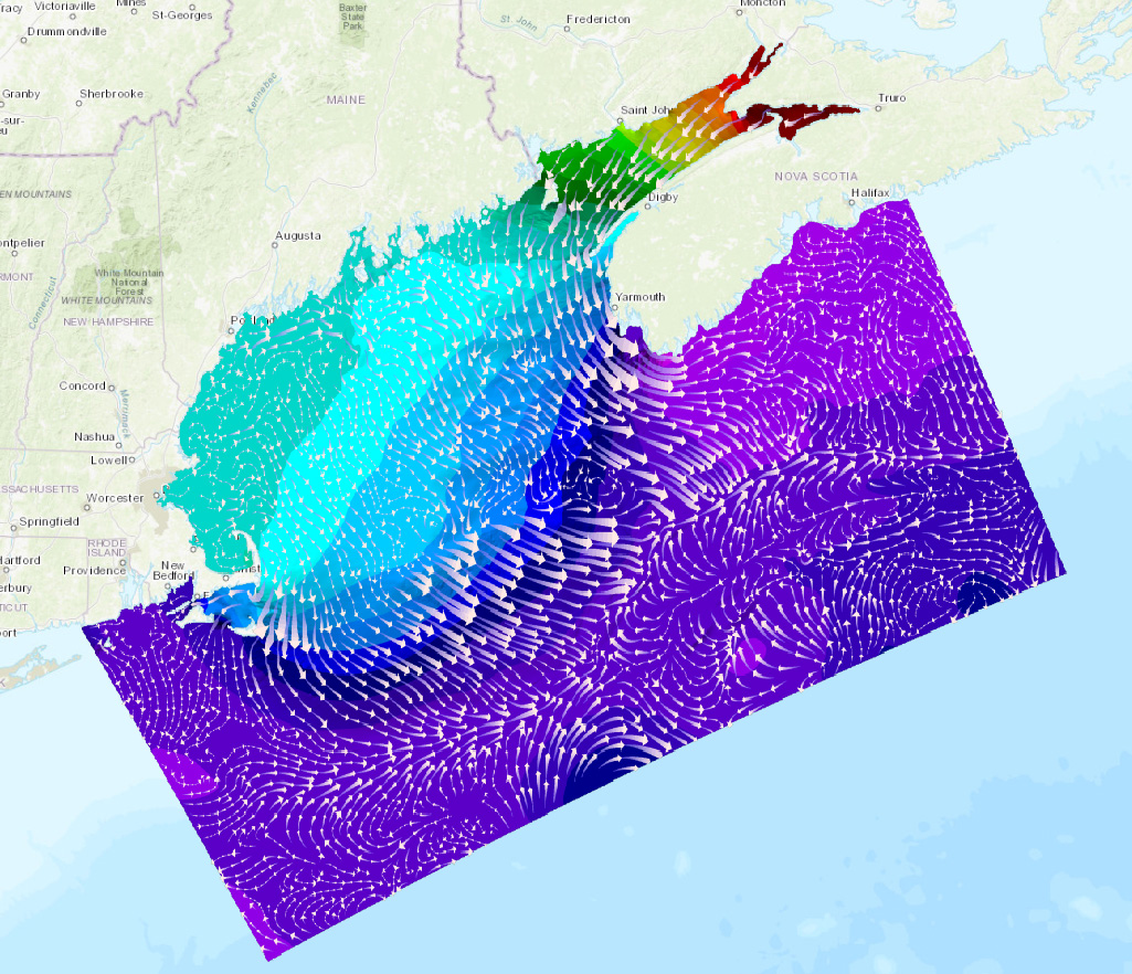
This month, NOAA unveiled the new Gulf of Maine Operational Forecast System (GoMOFS). This system provides users with real-time and forecasts of surface water levels, 3-D fields of water currents, water temperature, and salinity out to 72 hours. GoMOFS predictions support safe and efficient marine navigation, allowing mariners to plan their routes and avoid accidents. The system’s nowcasts and forecasts can also aid in emergency response, ecological applications, coastal management, and harmful algal bloom forecasts. Continue reading “Introducing New Gulf of Maine Operational Forecast System”

Surveyor Spotlight: NOAA navigation response team member, Erin Diurba

Erin Diurba, hydrographic surveyor on NOAA navigation response team 4, homeported in Galveston, Texas.

Have you ever wondered what it is like to work on a NOAA navigation response team (NRT) or what makes our team members experts in their field?
The Office of Coast Survey deploys NRTs across the country to conduct emergency hydrographic surveys requested by the U.S. Coast Guard, port officials, and other first responders in the wake of accidents and natural events that create navigation hazards. In their day‐to‐day, non‐emergency role, the NRTs work in the nation’s busiest ports, surveying for dangers to navigation and updating nautical chart products.
Meet Erin Diurba, a NOAA navigation response team member homeported in Galveston, Texas. Her self-described “survey wanderlust” has taken her across the globe to gain hydrographic surveying expertise on diverse teams and in unique environments. She tells her story here in this story map. Continue reading “Surveyor Spotlight: NOAA navigation response team member, Erin Diurba”

NOAA navigation response team responds after ferry strikes submerged object

By Lt. j.g. Dylan Kosten

On November 27, 2017, a New York City ferry departing from Pier 11 in the East River struck an underwater pylon, stranding over 100 passengers. The pylon was most likely from the remains of an old pier demolished several years earlier. At the request of the U.S. Coast Guard (USCG), NOAA’s navigation response team 5 (NRT 5), homeported in New London, Connecticut, assisted in the investigation.
Continue reading “NOAA navigation response team responds after ferry strikes submerged object”

NOAA Corps officers play important role in hydrography at NOAA

ENS Michelle Levano helps guide a launch back to NOAA Ship Rainier during a hydrographic surveying project in Channel Islands National Marine Sanctuary, California.

By Nick Perugini

In 2017, we celebrated the NOAA Corps Centennial, marking 100 years of valued service to the nation. Today’s NOAA Corps officers play an important role in the Office of Coast Survey. Officers serve as field hydrographers, technical experts, and managers throughout the charting organization. There is a distinct career path for NOAA Corps officers in Coast Survey that provides the opportunity to develop technical expertise in hydrography and at the same time, advance in rank in the NOAA Corps.  
Continue reading “NOAA Corps officers play important role in hydrography at NOAA”