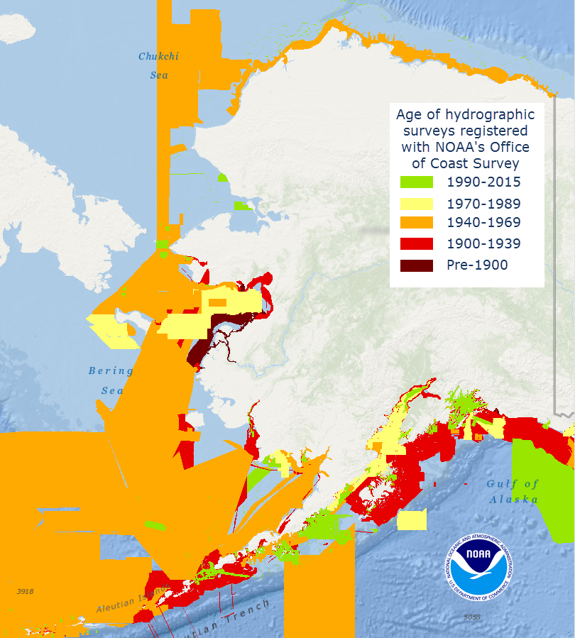
Alaska’s nautical charts need to be updated — we all know that. The diagram below shows the vintage of survey data currently used for today’s charts in Alaska. The graphic includes all surveys done by NOAA’s Office of Coast Survey (and its predecessors), and some limited data acquired by other agencies, i.e., the U.S. Coast Guard. Areas that are not colored in have never been surveyed or have data acquired by another source — from Russia or Japan, for instance — before the U.S. was responsible for charting in that area.
Continue reading “What does the age of the survey mean for nautical charts?”
Coast Survey participates in international Arctic survey project
By Edward Owens

Hello to all from the Canadian Coast Guard vessel Louis S. St-Laurent (CCG LSSL), affectionately called the ‘Louis.’ She is an impressive 120 m long, 24.5 m wide with a cruising range of 23,000 nautical miles and carries two CCG helicopters. There are 86 cabins with 100 bunks and today she currently sails with 77 souls on board. I’ve gotten lost, turned around, and confused while navigating my way through the labyrinth of neat and tidy stairways, corridors, and doorways on numerous occasions. Luckily, I’m beginning to find my way around thanks to all the artwork and placards mounted on the walls which I’ve depended on as landmarks to help me get where I’m going. Everything is arranged on five main decks. I am berthed on the 300 level or the flight and boat deck conveniently near the acoustics science lab. The galley is three decks down and as long as I can find it, I’ll be just grand.
Continue reading “Coast Survey participates in international Arctic survey project”
NOAA holds international workshop for nautical chart agencies

This week, hydrographers from 11 different countries traveled to Silver Spring, Maryland, to attend a workshop on nautical chart adequacy. Workshop participants included scholar students from the General Bathymetric Chart of the Oceans Organization, and participants from Israel, Malaysia, South Korea and United Kingdom. The workshop, developed and hosted by Coast Survey and the Joint Hydrographic Center, University of New Hampshire, trained the hydrographers on procedures to assess the adequacy of their respective nautical charts using publicly-available information.
Continue reading “NOAA holds international workshop for nautical chart agencies”
Coast Survey attends first meeting of IHO’s Nautical Information Provisions Working Group
Coast Survey attended the first meeting of the Nautical Information Provisions Working Group (NIPWG) held at the International Hydrographic Organization in Monaco.
During the meeting, Coast Survey’s Tom Loeper, chief of Navigation Services Division’s Coast Pilot branch and Great Lakes navigation manager, was reappointed as the secretary for the working group, a position he has held for 2 years. Two other working group members from the United States also attended the meeting, Briana Sullivan from the University of New Hampshire, and Mike Kushla from the National Geospatial-Intelligence Agency.
Continue reading “Coast Survey attends first meeting of IHO’s Nautical Information Provisions Working Group”
Coast Survey aids U.S. Coast Guard in recovering sunken buoy
Coast Survey’s Navigation Response Team (NRT) 6 responded to a request from the U.S. Coast Guard to locate and facilitate recovery of a sunken mooring buoy near Sausalito, California.
Although not a threat to surface navigation, there are two reasons for this recovery effort. The first is to protect mariners from getting their anchors caught on the buoy or tangled in the mooring chain. Recovery will also allow the U.S. Coast Guard to repair and possibly reuse the buoy.
Continue reading “Coast Survey aids U.S. Coast Guard in recovering sunken buoy”
NOAA dedicates memorial at Absecon Lighthouse
Sunday, June 21, was World Hydrography Day, a day set aside to recognize the important work of hydrographers. Measuring and describing the physical features of oceans, seas, and coastal areas is essential not only to the safe navigation of the everyday mariner, but to our nation’s economic development, security and defense, scientific research, and environmental protection.

This year’s observation was particularly noteworthy for NOAA, as we honored the lost crew members of the U.S. Coast Survey Steamer Robert J. Walker, by dedicating a memorial at the Absecon Lighthouse in New Jersey.
On June 21, 1860, the Robert J. Walker was hit by a commercial schooner while transiting from Norfolk to New York after months of surveying in the Gulf of Mexico. The ship sank 12 miles offshore, as they were heading to the Absecon Lighthouse after they were hit. Coast Survey lost twenty crew members that night, and another man died from his injuries the next day, in the largest single loss of life in Coast Survey and NOAA history.
Continue reading “NOAA dedicates memorial at Absecon Lighthouse”
Over 35,000 conductivity, temperature, and depth profiles added to public oceanographic database
Well before the invention of the computer and the following onslaught of digital data, S.R. Ranganathan in his 1939 book, “Theory of Library Catalogue,” described in detail how a library catalog should work and be prepared. Since then, the way we develop and maintain information databases and archives has dramatically changed. The format has morphed beyond traditional books and journals to large amounts of digital data.
The Office of Coast Survey alone produces digital data on order of several terabytes a year, and much of this data is collected by NOAA hydrographic survey vessels. In order to make the data easily accessible and available to the public, it is formatted and submitted to the National Center for Environmental Information (NCEI) ocean data archive. Here, the basic principles of library cataloging apply – find the appropriate information quickly and in the location it is supposed to be stored.

Continue reading “Over 35,000 conductivity, temperature, and depth profiles added to public oceanographic database”
Ceremony in Kodiak, Alaska, marks the deployment of NOAA ships Fairweather and Rainier
To mark the deployment of NOAA ships Fairweather and Rainier as they begin a summer of hydrographic survey projects in the Arctic, NOAA hosted a ceremony at the U.S. Coast Guard (USCG) base in Kodiak, Alaska.
The ceremony opened with a joint USCG and NOAA color guard while the national anthem was sung by retired USCG Chief Aviation Machinist Mate, Joe Symonoski. Rear Admiral Gerd Glang, director of the Office of Coast Survey, gave opening remarks.

“Characteristically, we are quite modest about the missions and accomplishments of our NOAA ships. But today, we are taking the time to recognize the planned deployment of both ships to undertake hydrographic surveys in the U.S. Arctic,” Glang said. “It is important for us because of the renewed investment NOAA is making in this region at a time when the Arctic has become more accessible to marine transportation.”
Continue reading “Ceremony in Kodiak, Alaska, marks the deployment of NOAA ships Fairweather and Rainier”
Coast Survey helps communities prepare for the 2015 Atlantic hurricane season
June 1 marks the beginning of the 2015 Atlantic hurricane season. Although NOAA projects it to be a below normal season, it doesn’t mean coastal areas will have it easy. In the wake of a hurricane, Coast Survey plays a critical role in NOAA’s response efforts. But what about before the storm? In addition to building relationships and coordinating emergency response capabilities with agencies such as U.S. Coast Guard, U.S. Army Corps of Engineers, and port authorities, Coast Survey focuses on local community preparedness meetings and outreach events throughout the month of May.
Recently, Coast Survey’s navigation manager for the central Gulf Coast, in partnership with The National Weather Service Lake Charles and the Port of Morgan City, Louisiana, conducted public preparedness forums in Lafayette, Lake Charles, and Morgan City. One meeting featured U.S. Representative Charles W. Boustany, Jr., as the speaker. Approximately 90 people attended, including the congressman’s constituents, and local, state, and federal agencies and responders. The information provided was of vital interest given the upcoming start of hurricane season and the 10th anniversary of hurricanes Katrina and Rita.
Continue reading “Coast Survey helps communities prepare for the 2015 Atlantic hurricane season”
All aboard! NOAA’s Bay Hydro II opens its doors to the public at the Port of Baltimore’s National Maritime Day Event
What better way to recognize National Maritime Day than to spend a day at the Port of Baltimore talking with the public about NOAA’s hydrographic survey work. Coast Survey’s research vessel Bay Hydro II, moored at pier 13 Canton Marine Terminal across from the NS Savannah, participated in the Port of Baltimore’s National Maritime Day celebration on Sunday, May 17.
A great cross-section of visitors came on board throughout the day. From students and families with small children to retired Navy sonar operators, there was no shortage of enthusiastic people to talk to.
Continue reading “All aboard! NOAA’s Bay Hydro II opens its doors to the public at the Port of Baltimore’s National Maritime Day Event”
