Office of Coast Survey
National Oceanic and Atmospheric Administration
U.S. Department of Commerce
Office of Coast Survey
National Oceanic and Atmospheric Administration
U.S. Department of Commerce
August 10, 2022
It is a rare privilege to see the habitats we are mapping. The National Centers for Coastal Ocean Science lead Deepwater Horizon Natural Resource Damage Assessment has provided one of those rare opportunities where the foundational bathymetric and backscatter data is being used to identify key mesophotic and deep benthic habitats for remotely operated vehicle exploration. Coast Survey is assisting in this collaboration with two of eight 2022 expeditions in the Gulf of Mexico, and the recently acquired data on NOAA Ship Ship Ferdinand R. Hassler. Hassler recently finished one of these projects providing foundational bathymetric and backscatter data across 785 square nautical miles of the seafloor (an area larger than Rhode Island). These data are now being used to identify key mesophotic and deep benthic habitats for remotely operated vehicle exploration, and to update the nautical charts covering the area. For more information, see Scientific Cruises Set Sail to Help Restore Open Ocean Communities, and the Wavelengths Summer Edition 2022 news article, Seafloor Mapping and Coral Sampling: Two of Eight Scientific Cruises Complete.
Northeast Navigation Manager Colleen Roche along with Julia Powell and Lucy Hick, visited the Sandy Hook Pilots and U.S. Coast Guard District 1 to discuss the prototype S-102 (bathymetry) data. They also discussed the ongoing nautical chart transition and demoed the NOAA Custom Chart application and the Nautical Chart Display System. The pilots were able to ingest the prototype S-102 data into a Trelleborg Safepilot system and use that data to extract a user defined safety contour. The layering algorithm still needs work so that the LandArea overlay is shown above the S-102 data. Special thanks goes out to Barry Gallagher for updating the S-102 processes to the latest edition of S-102, Erin Nagel for her development work to automate the ingestion into the Precision Marine Navigation dissemination system that also creates the relevant discovery metadata, Colleen Roche for her coordination with both Trelleborg and the Sandy Hook Pilots and Jeff Ferguson for his coordination with the Jacobsen Pilots and SeaIQ. For more information, contact Collen.Roche@noaa.gov.
The Gulf Coast is seeing several new liquid natural gas (LNG) export terminals being built and going online. Coast Survey is very active in working with the pilots across the Gulf to update nautical charts with new terminals and with expansions/additions to existing terminals. In the case of Venture Global's new LNG terminal at Calcasieu Pass, Coast Survey worked with the company and pilots to apply a new harbor, new docks and mooring areas to the nautical charts in time for the first ship arrival earlier this year. Another facility at Sabine Pass, the Cheniere LNG facility – the nation's largest – needed a third berth to handle a growing number of vessels. Coast Survey's navigation managers conducted field visits to gather information and the company provided detailed drawings and diagrams of the new third berth to the Marine Chart Division and Hydrographic Surveys Division. With the cost of the vessel and a full load of LNG, the overall value of just one shipment is greater than half a billion dollars. Cheniere Sabine Pass can load over 40 LNG carriers a month from its facility and (soon) three berths. The accuracy and timeliness of charting these facilities has become very important. Just one facility with an unplanned disruption has seen an economic impact on gas prices in Europe rise significantly. For more information, contact Tim.Osborn@noaa.gov.
Weekly Hydro Ship Activity Report – July 10 through July 16, 2022
Weekly Hydro Ship Activity Report – July 17 through July 23, 2022
Weekly Hydro Ship Activity Report – July 24 through July 30, 2022
Navigation Response Team Activities
NRT-New London completed surveying their assigned priority area in the Wisconsin Shipwreck Coast National Marine Sanctuary. Local media met with the crew and sanctuary personnel on Friday, July 29 to learn more about the survey work being conducted in the area. The team traveled to Detroit, Michigan to meet with NOAA Ship Thomas Jefferson's survey launch and crew and begin their joint survey in the Detroit River on August 4.
NRT-Seattle is completing their Grays Harbor, Washington survey. Once finished by the end of the week, they will start surveying the upper Columbia River in support of the Columbia River Inter-Tribal Fisheries Commission.
NRT-Fernandina Beach completed their assigned survey of Florida Keys National Marine Sanctuary on August 5. The sanctuary and Navigation Response Branch will have an after survey debrief and start discussions for next year's survey plans in the sanctuary.
NRT-Stennis uncrewed systems is working on their survey in Biloxi Bay. A new POS/MV was installed and integrated last week, better preparing them for response work.
Bay Hydro II's engine repair contract was awarded last week. A start and completion date will be determined by the end of this week, once lead time for parts and contractor availability have been determined. LTJG Jane Saunders became officer in charge of Bay Hydro II on July 27. In addition, the crew of Bay Hydro II visited headquarters in Silver Spring on July 26. They toured the NOAA Corps Commissioned Personnel Center, met with RDML Evans and had in person discussions with other Coast Survey personnel. They also took a quick stop on the 15th floor, to the NOAA Deputy Under Secretary's front office.
Mike Davidson, of the Navigation Response Branch, coordinated and supported the NOAA Small Boat Summit in Coast Survey's 6th floor large conference room. Representatives from across NOAA's small boat program community gathered to discuss updates on policy among other priority actions brought forth by the program.
Dan Garatea and Surafel Abebe supported NOAA Ship Thomas Jefferson during an 18-day deployment surveying the approaches to Cleveland.
The Hydrographic Surveys Division is excited to announce that several colleagues have been selected for opportunities to develop their leadership skills and support multiple important initiatives throughout NOAA.
Tyanne Faulkes was selected for the NOAA West Leadership Development Program. Tyanne is one of 18 total participants and one of two people representing NOS in the cohort. The 18-month leadership program will commence in October with a 20% time commitment, so Tyanne will continue to support the division while pursuing this exciting opportunity.
Christina Belton was selected for a LANTERN opportunity with NOAA's Ocean Exploration in the Science and Technology Division. As an Ocean Exploration technologist, Christina will evaluate the ocean exploration technology portfolio from uncrewed systems to data processing workflows. This opportunity will extend from the end of July through December and also allow Christina to continue to pursue physical scientist support aboard the hydrographic fleet.
Adam Argento was selected for a LANTERN opportunity as the NOAA Climate and Equity Heat Resilience Project Manager. Adam will coordinate with multiple NOAA line offices and regional teams to plan and implement pilot projects that combine citizen science, emergency planning, and other interventions to reduce heat risk for vulnerable and underserved communities. The 18-month detail will start this fall with a 50% time commitment, so Adam will continue to support HSD while managing the project.
Congratulations to Adam, Christina, and Tyanne!
did you know?
Be sure to check out the summer edition of the NOS Wavelengths newsletter that came out on Wednesday July 27. Read articles about the NOS workforce contributions to the new NOS strategic plan, resilience tips from the Chief of Behavioral Health and Wellness, and scientific cruises on seafloor mapping and coral sampling completed by NCCOS and partners!
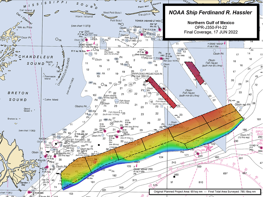 A graphic showing a chart of the Gulf of Mexico with survey area representing 2022 survey results from NOAA Ship Ferdinand R. Hassler.
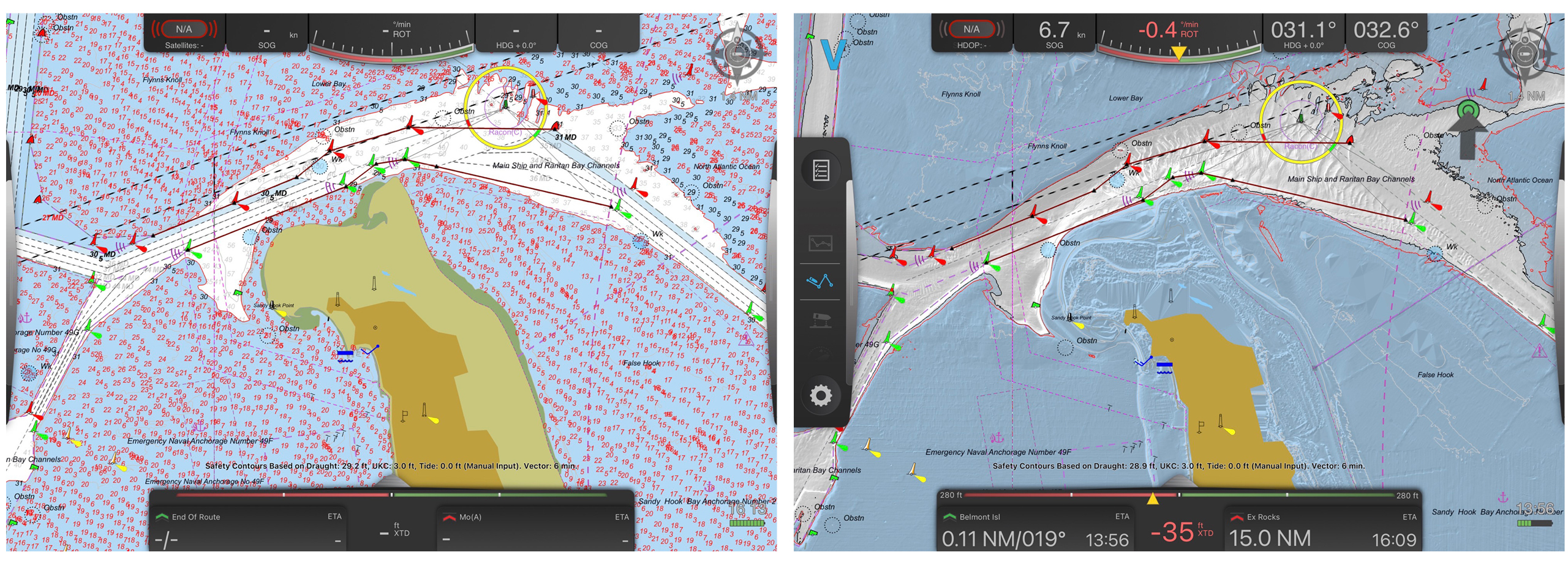 An image showing two screen shots of a portable pilot unit with S-102 data turned off (left) and S-102 data turned on (right).
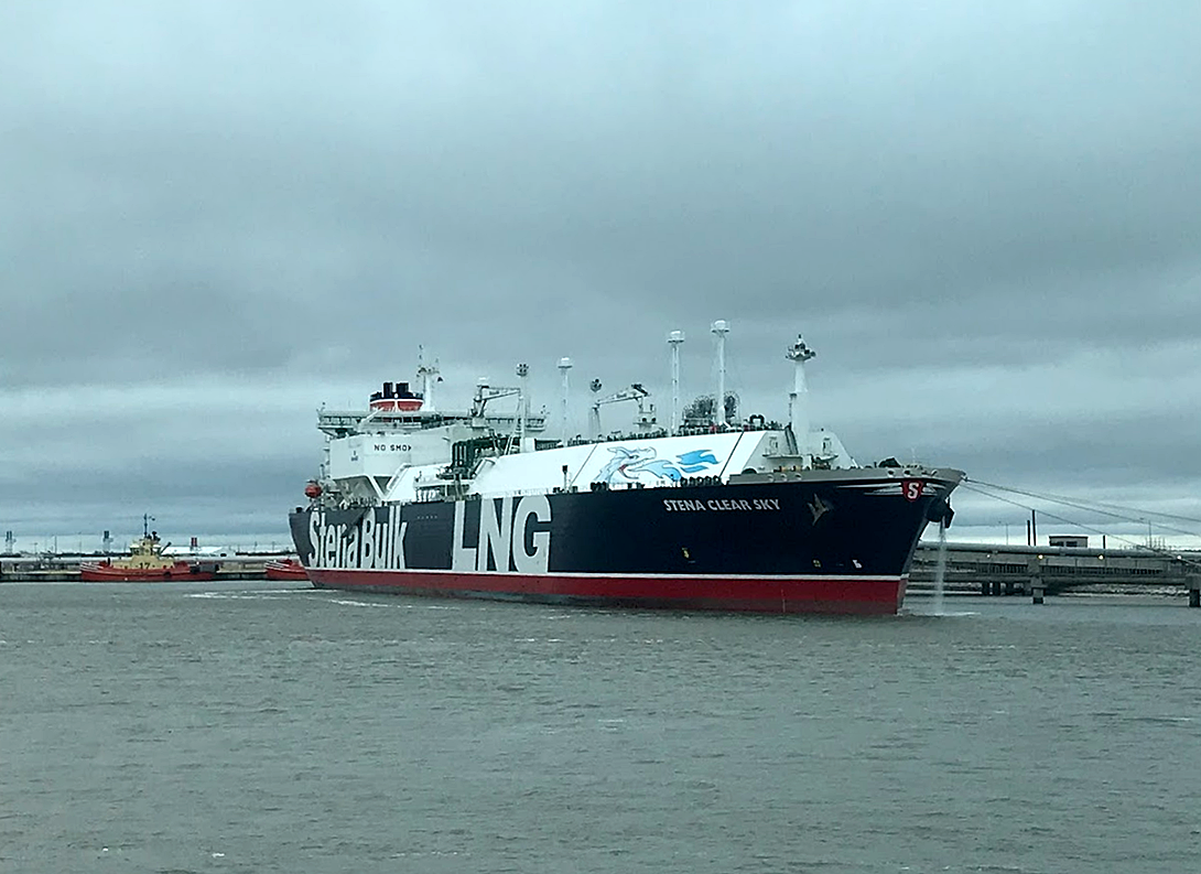 An image showing a liquid natural gas vessel loading cargo at Sabine Pass, Louisiana. (Credit: NOAA/Tim Osborn)
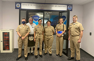 Team members of the Bay Hydro II visit the Office of the Under Secretary for Oceans and Atmosphere. From left to right: LTJG Kevin Tennyson, Robb Mowery, LTJG Carly Robbins, CDR Olivia Hauser, LTJG Jane Saunders, CAPT Chris van Westendorp.